
|
|
Mountain/Rock |
|---|---|
|
|
39.29025°N / 119.9815°W |
|
|
Washoe |
|
|
Hiking |
|
|
Summer, Fall |
|
|
9610 ft / 2929 m |
|
|
Overview
Rose Knob sits along the southwest ridge of the Mount Rose Wilderness. It is about 1 ¼ miles west of Rose Knob Peak, and rises a couple hundred feet above the Tahoe Rim Trail.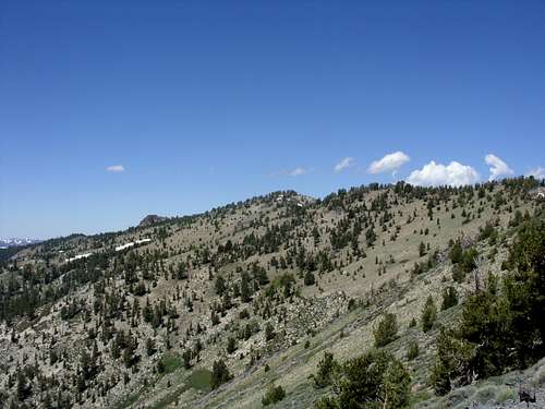
Rose Knob from the east
Getting there from the nearest Tahoe Rim Trail parking area is not realistic since it is about halfway between Tahoe Meadows and Brockway Summit. However, there is a relatively straightforward route from off Mount Rose Highway with about 7 1/2 miles of round trip hiking and a steep route from Incline Village that is over 6 miles round trip.
Views of Lake Tahoe are excellent from the Tahoe Rim Trail, as well as from Rose Knob (although the view to Lake Tahoe from the true summit is somewhat obscured by trees).
The best time to hike here is probably July through October when the Tahoe Rim Trail is free of snow. Any earlier in the season and there is greater risk of losing the trail and then getting lost in the woods.
Getting There
From Reno take Highway 395 to the Mount Rose Highway (431). The Mount Rose Highway runs for about 20 miles between Reno and Incline Village. Take 431 as it winds up the mountains. At the top of the road is the Mount Rose Summit at 8911’. Go past it. There are a couple spots to start the hike, but two primary areas off of Mount Rose Highway.The most straightforward way is to head about 1 1/2 miles past Mount Rose Summit to the edge of the Tahoe Meadows. On the right side of the road is a dirt road and parking area. This is Incline Lake Road. A gate blocks automobile access. Park anywhere around here.
If you want a little longer trail all the way up, head about 3 miles past Mount Rose Summit going towards Incline Village. Pass the phone booth on the right hand side of the road, and look for a dirt road on the right, about a mile past it. Head down the road, which terminates after a couple hundred yards. Park here, and look for the trail below. It is unmarked, but is right by the end of the road on the right hand side. The greatest challenge is finding the trail, but it goes right up the woods along the north side of a creek.
For a steep and more straightforward trail, head further down 431 past Country Club Road and head north on Marlette Way which quickly turns into Jennifer Street and reaches the trailhead in two-thirds of a mile.
Route Information
Route #1 – Incline Lake RoadJust across from the edge of Tahoe Meadows is Incline Lake Road. It is a fire road closed to motor vehicles, so you must park at the beginning of the road at about 8575’. Follow the road as it descends for about 1/2 mile. When the road loops around there is a cairn marking a trail. Take the trail which descends and connects to a trail heading north towards the peaks. The trail is confusing at times, especially when there is snow. You run into the connector trail described in route #2. Continue north up the trail as it heads around the north side of Incline Peak at a pass at 9,365' and you see a large rock formation ahead of you. That is at about 1 3/4 miles from the parking area.
Follow the trail down slightly, and it soon connects with another trail. This is the Tahoe Rim Trail. Head left reach Rose Knob Peak. The Tahoe Rim Trail here is on rocks and hard to follow sometimes. But a good suggestion is to just head to the summit of Rose Knob Peak, where you can see the way down to the Tahoe Rim Trail. Continue on to Rose Knob about 1 1/2 miles further.
The one way distance via this route is about 4 miles with an elevation gain of 1500 feet.
Route #2 – Connector Trail
This route starts off a dirt road 3 miles past Mount Rose Summit heading towards Incline Village. Finding the trail is the most difficult thing to do. It actually goes right up to the road, but isn’t perfectly obvious. Use your best judgment. It crosses a creek with a big piece of flat wood, and then skirts the base of Peak 9561. The dirt road is at about 8200’. The trail will climb up through the forest to the main ridge between Peak 9773 and Incline Peak in about 2 miles, gaining about 1265 feet in the process. Once at the ridge, you will see the spires below Peak 9773. Follow the trail down slightly, and it soon connects with another trail. This is the Tahoe Rim Trail. Head left to reach Rose Knob Peak and then as with Route #1, you will head down to the Tahoe Rim Trail and continue on to Rose Knob.
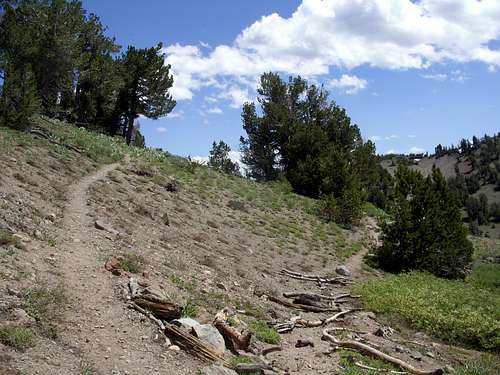
The connector trail meets the Tahoe Rim Trail

Final ascent to the summit of Rose Knob
The one way distance via this route is about 4 1/4 miles with an elevation gain of 1650 feet.
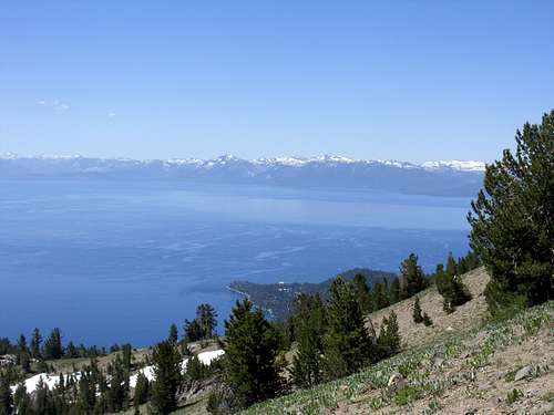
Lake Tahoe and the Desolation Wilderness from Rose Knob
Route #3 - Jennifer Street - Incline Village
From the trailhead at about 7,438’ take the trail steeply up over 2,000 feet, in less than 2 miles to the Tahoe Rim Trail. Then, head west about 1 1/4 miles towards Rose Knob, gaining about 200’ more in the process. It is about 6 1/4 miles round trip.