
|
|
Mountain/Rock |
|---|---|
|
|
39.23613°N / 119.9065°W |
|
|
Washoe |
|
|
Hiking, Scrambling |
|
|
Summer, Fall |
|
|
8703 ft / 2653 m |
|
|
Overview
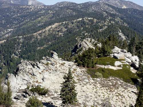
Surprisingly unnamed, the striking Peak 8703 is located on the east side of Lake Tahoe (on the Nevada side of the Lake). Its summit can reached via a short climb from the Tahoe Rim Trail. It has a prominence of approximately 385', so it is definitely its own peak. It is not a well known summit in the area, but due to its rocky top above the trees, it has spectacular views in all directions.There are three routes to the summit; the Flume Trail and Diamond Peak ski area from the west side and a longer route from the north side via the Tahoe Rim Trail from Tahoe Meadows. The Tahoe Meadows route is ideal for trail running, since it does not have significant ups and downs along the way.
Because it hosts a series of rocks below its summit, there are class 3 and class 4 routes than can be attempted up these rocks. The summit itself involves class 2 scrambling.
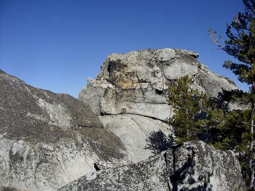
False summit - rock tower about 200 yards north of the summit.
The true summit rock
There is a lot of snow on this section of the trail between December and May. By late May, early June, the trail usually loses most of its snow. The bikers usually don’t come until the snow is completely gone; usually be early July. The best time to hike is probably during the fall (late September, October, November) when temperatures are lower, and there is little to no snow.
Getting There
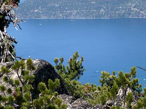
Northeastern Lake Tahoe from the summit
The long route via the Tahoe Rim Trail starts at Tahoe Meadows. From Reno take 395 to the Mount Rose Highway (431). Take 431 as it winds up the mountains. At the top of the road is the Mount Rose Summit at 8911’. The Tahoe Meadows starts less than a mile past it. Follow 431 until the end of the meadow where you can access the Tahoe Rim Trail. The elevation here is about 8555’.
For the Flume Trail route, from Reno take 395 to the Mount Rose Highway (431). Take 431 as it winds up the mountains. Pass Mount Rose Summit and Tahoe Meadows and continue to drive down from the pass. Continue to the junction with Highway 28 and go south for about 3 miles. You will see signs for the Flume Trail on your left. This is the start of the Tunnel Creek Road. Dozens of people park on the side of Highway 28 and that typically offers sufficient parking, even on a busy summer weekend.
It is also possible to hike Peak 8703 from the Diamond Peak Ski Resort, as mentioned above. From Highway 431, a little before you get to Incline Village, turn left on Fairview Blvd and follow for about 2 miles to Ski Way. Follow for about ½ mile to a parking area.
Route Description
Tahoe MeadowsFor the longer route at Tahoe Meadows, head into the meadow where there are a few trails. Follow the one that hugs the edge of the meadow. Pretty soon there are signs pointing to the Tahoe Rim Trail. Head into the forest, where the trail slowly ascends and then descends again. There are a few more ascents and descents along the way.
A little over 5 miles up the Tahoe Rim Trail, you can see the top of the Diamond Peak ski lift. Continue along the Tahoe Rim Trail where Peak 8703 soon comes into view.
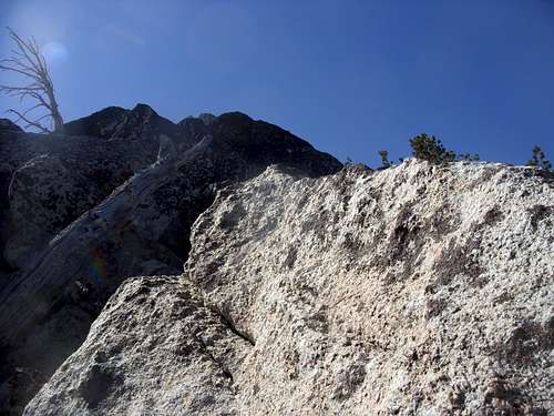
About 1 ¼ miles past Diamond Peak the trail veers left and starts to descend. Head up the woods to the obvious ridge towards Peak 8703. There are several big rock formations, but none of these are the summit. Continue south along the ridge, and descend slightly. Then head back up to the true summit, which is obvious. It requires some scrambling.
The total ascent and descent along this route is hard to figure, since it is basically out and back, and with plenty of ups and downs. Overall, expect at least 1,000’ of gain on the way up. You will gain at least three-quarters of that on the way back. The total round trip hiking distance is a little over 13 ½ miles. The longer route is recommended for bikers or trail runners.
Flume Trail
The Flume Trail is probably the best and most straight forward route to take. Start at Tunnel Creek Road. After less than 1/2 mile you reach dirt and the entrance to the wilderness. The wide trail climbs about 1600 feet in 3 3/4 miles to the Tahoe Rim Trail.
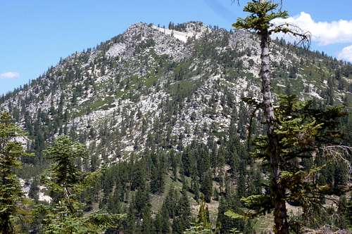
Looking back at Peak 8703 from the Flume Trail
Once at the TRT, head north (left) for about 1 1/4 miles to the base of Peak 8703. From here it is a nasty scramble. Head straight up through the rocks and brush for about 550 feet to the summit in about 1/3rd of a mile, depending on how you approach. It will take some time to find the best route, since it is pretty steep. To descend, go north of the summit where you will see a sandy way down. This is not a good way to ascend, but a great way to descend. It takes 5-10 minutes to get back to the Tahoe Rim Trail. Now you are about 1 1/2 miles from the Flume Trail and the way back down. The total round trip hiking distance is a little over 11 miles with a one-way elevation gain of about 2400 feet.
Diamond Peak Ski Area
The shorter route involves more elevation gain, but is the best option for hikers. From the ski lodge parking area (~6780’) follow a dirt road and head towards the ski run furthest to the right. It takes about 1½ miles and 1,750’ to the top of the Diamond Peak ski lift. The Tahoe Rim Trail is just below the ski lift. Head back onto it, and follow the same route as described in the longer route.
The total round trip hiking distance is about 6 miles, with a one way elevation gain of about 2,200’.
Looking straight down from the summit to the rock formations below
Red Tape
There is no red tape for the short route that I am aware of. Just park and hike. There are no permits needed to hike on the Tahoe Rim Trail or any fee to park at the Tahoe Meadows. When the pass gets heavy snows, roads may be closed. Roads may also be closed during the summer due to fire danger.During the summer, bikers are frequent on the Tahoe Rim Trail, especially near Tahoe Meadows. Biking the 9.2 miles between Tahoe Meadows and Tunnel Creek Rd. is allowed only on even numbered days. From Tunnel Creek Rd. to North Canyon-Hobart Rd. biking is allowed every day, but not on the 1 mile Marlette Peak Trail segment on the west side of Marlette Peak. Bikes are not allowed between North Canyon-Hobart Rd. and Spooner Summit. One can ride 5 miles down the North Canyon road to the parking area and facilities at Spooner Lake. If hiking when they are on the Tahoe Rim Trail, be careful, and watch for them. Always be wary on the Flume Trail where many bikers frequent, and ride fast downhill.
External Links
Lake Tahoe Basin Management UnitTahoe Rim Trail maps and information