
|
|
Mountain/Rock |
|---|---|
|
|
39.32443°N / 119.91042°W |
|
|
Washoe |
|
|
Hiking, Bouldering, Mixed, Scrambling |
|
|
Spring, Summer, Fall |
|
|
9282 ft / 2829 m |
|
|
Overview
The “Tamarack Lake rocks” is a series of summits rising just north of Tamarack Lake in the Mount Rose Wilderness. No trails lead to them. Bushwhacking is required. However, access is still relatively easy given the rocks are not much more than half a mile from the Mount Rose Highway (route 431), and thus can be reached without much of an approach.The southwest summit is made up of a series of rocks that can be scrambled up, the highest being about 9245’. Difficulty ranges from class 2 to class 4. The rocks continue along the ridge back to the brushy-topped Point 9282, the central and highest summit. The east summit, Point 9202 isn’t as rocky, but is the most distinct point when viewed from Tamarack Lake.
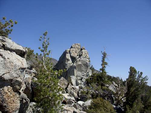
Southwest summit rock
There are wonderful views of surrounding peaks, including Mount Rose, Mount Houghton, Tamarack Peak and Slide Mountain. These rocky hills are quite impressive and offer excellent off-trail scrambling to get a unique view of the high peaks in the Mount Rose Wilderness.
The best time of year to hike or climb here is probably in July through October. June is often too wet and muddy, with snow still in the area. Part of the area is marsh, and the marsh is muddiest and thickest right after the wet spring season ends.
Getting There
From Reno take Highway 395 to the Mount Rose Highway (431). The Mount Rose Highway runs for about 20 miles between Reno and Incline Village. Take 431 as it winds up through the mountains. Pass the Mount Rose ski area, and continue for about a mile and a half. Point 9202 comes into view, and you pass under it. A few hundred yards past Point 9202 and about ¾ miles before Mount Rose Summit (if coming from Reno) there is a place to park. It is on the north side of the road (opposite side from Slide Mountain). The elevation is about 8650’. There should be a sign saying “area closed to motor vehicles”. That just refers to the forest, and not the parking area.Route Description
From the parking area, walk right up into the woods. There are no trails. Go straight up below the crest of the summits a few hundred feet above. Try and avoid marshy areas. A topographic map may come in handy. The hike up is short, steep, and sandy. Try to stay where there are actually growing plants and trees. Areas on the left may provide better footing. Avoid hiking up the steep sand, although the sand isn’t so bad on the descent.The rocky area is the southwest summit, and should take about 15-20 minutes to reach from the parking area. Once there, you are free to scramble up and down the rocks and enjoy the views. The central summit, Point 9282, is less than ¼ mile away, but much less rocky. The summit is on the north end and the actual summit is a boulder, obscured from view on the way up. The east summit, Point 9202 is just 1/3rd of a mile further.
To descend back to the parking area from Point 9202, head back to the saddle between it and Point 9282, head down the steep slope, and you can reach the parking area in less than half a mile.
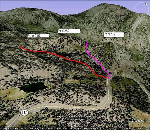
Google Earth™ image of the ascent and descent route the various summits. Tamarack Lake below