
|
|
Mountain/Rock |
|---|---|
|
|
39.38633°N / 119.85488°W |
|
|
Washoe |
|
|
Hiking |
|
|
Spring, Fall, Winter |
|
|
7219 ft / 2200 m |
|
|
Overview
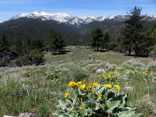
Flowery meadow
Dry Pond Peak would just be a point on the map if it weren’t for the trail network leading to its meadow like summit. Technically it is located about 1 mile east of the official Mount Rose Wilderness Boundary, but it is within the trail network on National Forest land, so it is part of the same forest that includes Mount Rose.
It is the summit directly east of Dry Pond, a popular destination which loops up and down the ridgetop connecting the Whites Creek Trail with the Thomas Creek Trail. Dry Pond generally has very little water besides some marsh. The name "Dry Pond Peak" is not official. On topographic maps, the mountain is referred to as 7,219. It has a prominence of only about 250'.
The summit can be hiked in 2 1/2 miles starting from the Whites Creek Trailhead off of Timberline Drive. Views are excellent, with nearly all of the major peaks in the Mount Rose Wilderness in view, as well as views east to the Virginia Range.
The summit appears to have been made more approachable by a controlled burn in the area that created a meadow-like path to the summit. The area further west is very dense forest, which means there are no other higher summits of interest on that ridge that can be reached without serious bushwhacking.
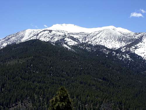
View of Mount Rose from the summit (4.5 miles away)
The advantage of this mountain is that it can be hiked early season or late season when the rest of the Mount Rose Wilderness is too covered in snow. Further, the trailhead is only 15-20 minutes drive from downtown Reno.
Dry Pond Peak can be hiked all year around. The best times are probably April, May, June, September, October, November.
Getting There
To get there from Reno, take 395 South to the Mount Rose Highway (rt. 431). Once on 431, take it to the west for about 4 1/2 miles until you see Timberline Drive on your right. Turn right on Timberline Drive and then drive uphill for about ½ mile, and you will see a sign on the left to the Whites Creek Trailhead. A short bit up the road, its turns to dirt, but the road remains very well graded. It is about ¾ miles up to the trailhead.Routes
From the trailhead, hike about 1 1/3 miles up to the junction with the Dry Pond Trail on the right. Follow the trail up for about 0.85 miles to Dry Pond. At Dry Pond, head up the open meadow on the east side of the lake. It is about three-tenths of a mile and 265 feet to the summit. There is a faint use trail up the meadow, but it fades in and out.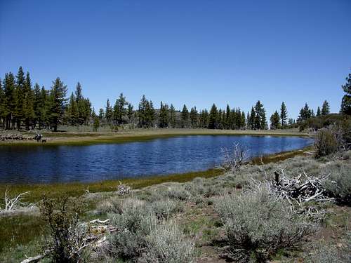
Dry Pond
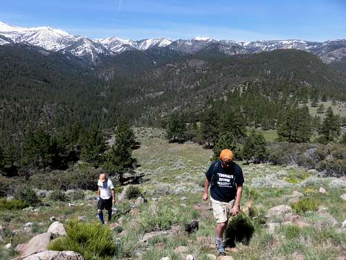
Heading up the meadow to the summit
The round trip hiking distance is about 5 miles, with a one-way elevation gain of about 1,000 feet.
The summit can also be approached from the north via the Thomas Creek Trailhead. Drive another ½ mile past the Whites Creek Trailhead to the Thomas Creek Trailhead off of Timberline Drive at about 5990’. Head about 1 ½ miles up the Thomas Creek Trail to a trail junction. Head left up the trail towards Dry Pond. At about 3 miles the pond is reached. Then head around the other side of the pond. Another three-tenths of mile and 265 feet is required to reach the summit. All told, this hike is about 7 miles round trip with an elevation gain of 1230 feet.
These two can be combined as a loop starting at either Whites Creek or Thomas Creek. Whites Creek is recommended as the starting point. This hike is about 7 1/2 miles.