
-
 8498 Hits
-
 85.51% Score
-
 21 Votes
|
|
Mountain/Rock |
|---|---|
|
|
38.81524°N / 122.68259°W |
|
|
Lake |
|
|
Hiking |
|
|
Spring, Summer, Fall, Winter |
|
|
3740 ft / 1140 m |
|
|
Overview
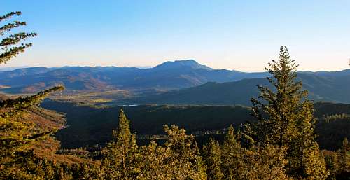
St. Helena from Boggs
Update: Expected to open again in October or so 2016. Boggs Mtn. and State Forest closed indefinitely due to Valley Fire. Oct. 6 '15
The mountain is almost totally burnt out!
Boggs Mountain has awesome views of dirt roads, trails, pine trees, manzanita brush and some oaks. The viewpoints are few on this big long wide thoroughly forested ridge-like mountain. But if you want to take a beautiful walk in a high forest, at one with nature and such or take a mellow mountain bike ride Boggs could float your boat for the day.
Boggs Mountain has awesome views of dirt roads, trails, pine trees, manzanita brush and some oaks. The viewpoints are few on this big long wide thoroughly forested ridge-like mountain. But if you want to take a beautiful walk in a high forest, at one with nature and such or take a mellow mountain bike ride Boggs could float your boat for the day.
Boggs is in the heart of the Mayacamas Range just across Cobb Valley from Cobb Mountain 4,728' the highest in the range.
Boggs is also Boggs Mountain State Forest with an entrance road elevation of 3,000'. A system of easy roads and trails weave their way across and between the rolling high points roughly 3,500 to 3,700'.
There is a shooting range and when i was down that neck of the woods (the far southeast end of the mountain) a paint ball group was punctuating the silence to a significant degree. But it's a big old mountain and plenty of places to find lengthy peaceful walks in the woods.
Friends of Boggs Mountain is a good site to get to know as well.![North from Mt. St. Helena]()
Cobb left, Hannah, Konocti back center, Boggs (mid left) and others from St. HelenaFrom Middletown take Hwy. 175 9.6 miles into the Cobb Mountain area and turn right just after a sharp uphill S turn at the Boggs State Forest entrance (Foresty Rd 9999). Drive in less than a mile for parking and entrance station area with maps etc..
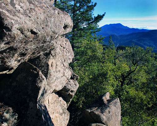
From Lakeport at the Scotts Valley exit on Hwy 29 go east 11.7 miles to Hwy 175. Go right into the mountains another 10 winding miles to Forestry Rd. 9999 just past Hobergs Resort.![Big rock face on Rd 500]()
Big rock face on rd 500 ![Bench at overlook atop the big rock face]()
View from bench atop the big rock face ![Rock cairn on rd 542]()
Small cairn rock pile leading to the viewpoint overlook on rd 542 ![Main forest rd 500]()
Forest Rd 500There are numerous trails routes roads etc.. The actual summit is all trees and is only discernable because you can't go any higher. It's all pretty easy grades of hiking nothing is really steep.
Click here for a good trail map from Friends of Boggs Mtn.
Where ARE the views if any on this mountain?
There is a fine view off the rim of the southeast end overlooking Collayomi Valley and a few others down the ridge just beyond the gate at the south end of Forest road 500.
There is a Vista Point on the trail map overlooking the the northeast end but it is way overgrown and hardly worth a visit.
Route to the best viewpoint at the southeast end: Take Forestry rd. 500 for 3.6 miles from the park entrance. where it junctions with rd. 540 coming down from the left. Take 540 .4 mile and get on rd 542 going right. 542 splits at .3 mile. Stay to the right and go about a quarter mile to a small pile of rocks just off the road to the right indicating Corkys' Trail but the sign is gone as of June '15. Take it out a short distance to the overlook. It's a swell view out southeast over Collayomi Valley with Mt. St. Helena dominating the view to the south.
There are also some views down Rd 500 past the locked gate at the junction with 540. Go down about a third of a mile and above to the right is a sizeable rock face about 60 ft. high that can be scrambled from the sides. Interestingly some folks have carried a bench up to the top which has some decent views to the northeast. There are also some good views of Cobb and St. Helena from the south end of the heliport area near the entrance to the park.
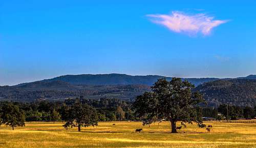
![Big meadow and Boggs Mtn.]()
Boggs Mtn. from Clearlake HighlandsCamping only in campgrounds. Campfires only in campgrounds. No hunting or shooting unless permissible. Motor vehicles must stay on roads. Keep pets leashed and controlled in camp area. Confine smoking to campgrounds.
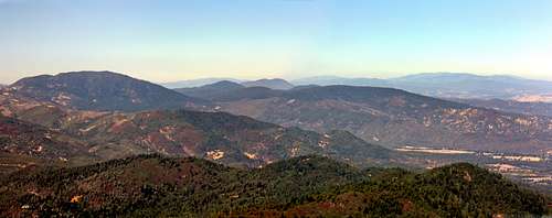
There is a kiosk near the entrance with maps and a bulletin board with more info.![Panorama from Boggs Mountain]()
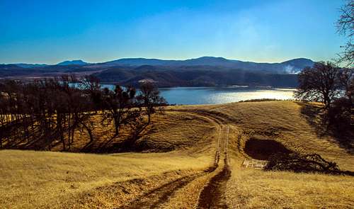
Panorama southeast from Boggs.Year around. Probably springtime. It gets hot and exceptionally dry in summer and can easily get snowed in in winter with roads temporarily closed.![South over Clear Lake to the Mayacama Mtns.]()
Over Clear Lake to St. Helena, Boggs, Cobb and HannahClick on this link for camping info.![West from Boggs Mtn.]()
West from Boggs near heliport ![Afternoon forest]()
Afternoon forest on Boggs west side ![Mt. St. Helena from Boggs Mtn.]()
St. Helena from Boggs heliport ![A stroll on Boggs]()
Stu Deans on Boggs west slopeClick here for the current weather and 10 day forecast for Cobb Ca.
There is a shooting range and when i was down that neck of the woods (the far southeast end of the mountain) a paint ball group was punctuating the silence to a significant degree. But it's a big old mountain and plenty of places to find lengthy peaceful walks in the woods.
Friends of Boggs Mountain is a good site to get to know as well.
Getting There
Cobb left, Hannah, Konocti back center, Boggs (mid left) and others from St. Helena
From Lakeport at the Scotts Valley exit on Hwy 29 go east 11.7 miles to Hwy 175. Go right into the mountains another 10 winding miles to Forestry Rd. 9999 just past Hobergs Resort.
Route

Big rock face on rd 500

View from bench atop the big rock face

Small cairn rock pile leading to the viewpoint overlook on rd 542

Forest Rd 500
Click here for a good trail map from Friends of Boggs Mtn.
Where ARE the views if any on this mountain?
There is a fine view off the rim of the southeast end overlooking Collayomi Valley and a few others down the ridge just beyond the gate at the south end of Forest road 500.
There is a Vista Point on the trail map overlooking the the northeast end but it is way overgrown and hardly worth a visit.
Route to the best viewpoint at the southeast end: Take Forestry rd. 500 for 3.6 miles from the park entrance. where it junctions with rd. 540 coming down from the left. Take 540 .4 mile and get on rd 542 going right. 542 splits at .3 mile. Stay to the right and go about a quarter mile to a small pile of rocks just off the road to the right indicating Corkys' Trail but the sign is gone as of June '15. Take it out a short distance to the overlook. It's a swell view out southeast over Collayomi Valley with Mt. St. Helena dominating the view to the south.
There are also some views down Rd 500 past the locked gate at the junction with 540. Go down about a third of a mile and above to the right is a sizeable rock face about 60 ft. high that can be scrambled from the sides. Interestingly some folks have carried a bench up to the top which has some decent views to the northeast. There are also some good views of Cobb and St. Helena from the south end of the heliport area near the entrance to the park.
Red Tape
Boggs Mtn. from Clearlake Highlands
There is a kiosk near the entrance with maps and a bulletin board with more info.
When to Climb
Panorama southeast from Boggs.
Camping
Over Clear Lake to St. Helena, Boggs, Cobb and Hannah
Weather and 10 day forecast

West from Boggs near heliport

Afternoon forest on Boggs west side

St. Helena from Boggs heliport

Stu Deans on Boggs west slope