Colorado High Res GPS Maps
| Page Type | Gear Review |
|---|---|
| Object Title | Colorado High Res GPS Maps |
| Manufacturer | Above The Timber |
| Page By | Alan Ellis |
| Page Type | Jul 29, 2007 / Jul 29, 2007 |
| Object ID | 3584 |
| Hits | 6629 |
| Vote |
Product Description
As most Garmin GPS users know, the Garmin Mapsource Topos are in 1/100 scale. This fact makes backcountry use of the topos on your GPS unit very limited and not very accurate. Now, however, Garmin users in Colorado have an option and a solution.... 1/24 scale maps for your Garmin GPS mapping unit.From the manufacturers website:
High Resolution Colorado Topographic Maps for Garmin GPS Receivers
Garmin created an incredible mapping GPS receiver and left off the key ingredient, high resolution maps. Garmin's sophisticated Operating System and mapping language allows for very useful and detailed topographic maps. Above the Timber is now filling that mapping void. Unlike so many "GPS enabled" map products on the market, these are maps inside the GPS, not just routes and waypoints.
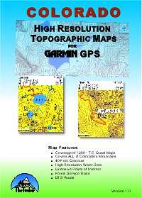
Will 24K Topos really work on such a small screen?
As the screenshots above demonstrate, a definite yes. While you will use a GPS Topo differently than a paper map, their are a number of distinct advantages to offset the obvious size difference. After one trip with one of these maps and you'll consign your large paper maps to their rightful place: hanging on a wall in your den.
Advantages of GPS Topos verses Paper Maps:
The most obvious advantage is the GPS Position Pointer. It places you on the map at your exact location . . . no more transposing via coordinates to a paper map, no more guessing.
Garmin Levels, the OS within the receiver and the multi-level structure of the maps intelligently adds/removes map detail as you zoom in and out, so that the screen is not overwhelmed with too much detail. You can customize this feature on the fly with Map Setup > General > Detail.
Seamless borders, adjacent maps seamlessly join one to another, unlike paper maps.
Vast scale, on a fingernail sized memory card you can hold all of Colorado's 24K topo maps, try that with paper quads. Now you can go to that next basin that's off your paper map and know where you're at, freedom.
Over zoom, unlike paper maps at a fixed scale and font size, these topo maps allow the individual users to zoom as needed for their eyesight, no need for a magnifier. Font sizes can also be adjusted over a broad range.
Map Pointer Info, want to find the elevation of a contour? Simply position the pointer on the contour, viola instant elevation. No more finding an elevation and following the line back to your area of interest and then counting lines.
Backlight, view the maps in any light condition from full sun to totally dark.
Waterproof, need to check the map in the rain, no problem, GPS receivers are waterproof, are your paper maps waterproof?
Windproof, ever try to read a paper map in a strong wind, acts like a sail doesn't it.
No folding and unfolding with the inevitable loss of detail at the folds.
Primary Map Features
- 40-Foot Contours
- 15-minute Coverage per Map
- High Resolution Water Data
- Extensive Geologic Feature Points
- Forest Service Trails
- BTS Roads
- Covers ALL of Colorado's Mountains
- Maps Work with Garmin Mapping GPS Receivers
- Cost
40-Foot Contours:
Unlike Garmin's USA Topo product, which has 40-Meter contour intervals, Above the Timber's Colorado Topos are at 40-foot intervals, the same as standard 7.5-minute USGS Quad maps. The 40-foot intervals are also in integer 40-foot increments, not meters converted to odd numbered feet.
High Resolution Water Data:
Besides the contour interval, the High Resolution Water Data is what makes these maps stand out. Most vector maps only have named water features, named lakes and streams. For every named water feature, their are 100-unnamed water features. To the extent possible with USGS water feature databases, ALL unnamed water features are on these maps. We're talking beaver pond resolution!!! Additionally, most Colorado rivers are shown at their true extent, bank to bank, not just a line indicating river.
15-minute Coverage per Map:
Each map segment covers an area of 15 x 15 minutes of arc or exactly 4 - 7.5 minute Quad Maps. These maps seamlessly join one to another, therefore you can have the entire coverage area as one seamless map inside your GPS receiver. Their are in total 320 - 15-min maps.
For a rule-of-thumb, a 15-min map covers roughly 13-miles E-W and 15-miles N-S. Note: the western most set of maps, along the Utah border, have an east-west extent of 21-minutes of arc.
Covers ALL of Colorado's Mountains:
Version 1.0 of the maps cover from W109‹ to W104‹ and N41‹ to N37‹.
Extensive Geologic Feature Points:
In addition to the expected summits; mines, cemeteries, arches, pillars, basins, springs, flats, ridges, cliffs and passes are shown. For example, Colorado has over 7000 named and positioned mines, they're all here! If you're in the vicinity of a mine, look for the mine symbol on your Garmin GPS for its name.
Summits: The topo maps contain over 3200 Colorado summits complete with all federal database errors. One of the Fourteeners was off 500-feet, all the Fourteeners were corrected to Above the Timber's elevation database. Since all the elevation data was in integer meters, all the elevation values, reported in feet are guaranteed to be off by the rounding error at least. However, the cup is still half full, at a minimum you'll know the name of that nearby summit of interest.
Forest Service Trails:
Colorado's National Forests are crisscrossed with numerous foot trails, aiding backcountry travel. If they were in the Forest Service database, they're on these maps. At this writing, the BLM trails are not yet included, awaiting the requested BLM data.
BTS Roads:
Oh my roads, does Colorado ever have a lot of roads. From boring interstate highways to gruesome 4WD roads, each described in a unique manner by each hosting county to the Bureau of Transportation Statistics. If their were ever a case for trusting your eyes and not your GPS, its roads. No, the roads are not routable.
Works with Garmin Mapping GPS Receivers:
While the maps should work on any Garmin GPS mapping receiver B&W or color, 1] they have not been tested on all receivers and 2] given the large file size of each map (100KB-2MB) these maps are intended for Garmin's "x" family of receivers which have interchangeable microSD memory cards up to 2GB. Or other Garmin GPS receivers with replaceable memory cards. The total size of all the maps installed into a Gmapsupp.img container file is 313 MB.
Basically, if you can now load Garmin's Mapsource USA Topo product, then this will also work.
Recommended models include the eTrex Vista/Legend/Venture Cx, the GPSMAP 60 Cx and CSx, and the similar 76 Cx series.
Here's a 1 MB test file which is a cluster of 4 - 15-min map segments east of Fort Collins. They're in a self-extracting executable file. The map files will appear in Mapsource as TopoDemo and you can load them into any Garmin mapping GPS. Caution: You MUST have Mapsource 6.x installed before running this executable. Download Topo Demo
Also, because this product is not authorized by Garmin, it is not recommended that these maps be used in conjunction with Garmin produced maps. These maps will in no way harm your Garmin receiver. They simply contain map software, no operating system software.
Cost: $79.95
For the cost of a dozen paper 7.5-minute USGS Quads, you can buy this CD with the same coverage as 1280 - 7.5-minute Quads. That's less than $0.10 per Quad equivalent.
For more information: www.AboveTheTimber.com
Images
 |
Alan Ellis - Jul 29, 2007 12:21 pm - Voted 5/5
What I've Been Waiting ForAnyway, this file is easy to download, easy to use, and the manufacturer is quick to answer questions or help you out via email. The best part is that once the file is downloaded into your system, you no longer need to use your Mapsource discs if needing maps of Colorado.
My only minor issue is with the cost. At $79.95, it is a little pricey, but overall, it is worth it. Also, I would like to eventually see other states available. Otherwise, this is a good product and highly recommended.