-
 2408 Hits
-
 76.66% Score
-
 7 Votes
|
|
Mountain/Rock |
|---|---|
|
|
47.33665°N / 10.46844°E |
|
|
Mountaineering, Trad Climbing |
|
|
Summer, Fall |
|
|
8635 ft / 2632 m |
|
|
Overview
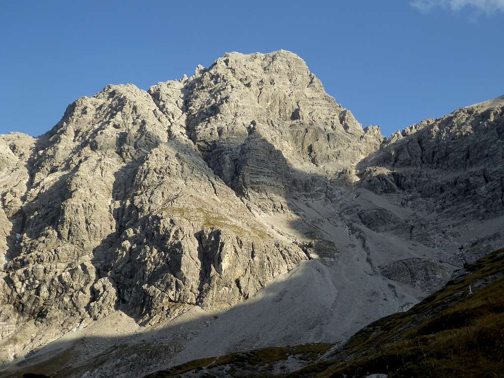
Hornbach range belongs to Allgäu Alps and forms the southernmost part of this area, hosting some of the highest Allgäu peaks. Urbeleskarspitze, a huge and impressive mountain, is among them. It is the second highest peak of Hornbach range and one of the most interesting mountains of the area.
Hornbach range separates huge Lechtal valley to the south from the tributary Hornbach valley to the north. About 1600 to 1800 m of altitude difference are between the valley floors and the summits. Steep slopes and huge rock faces are the characteristic landmarks of these mountains. Urbeleskarspitze is no exeption.


The summit is the culmination point of three ridges, thus forming a sort of triangle pyramid. To the southwest a ridge goes to Bretterspitze, nearly as high as Urbeleskarspitze. To the north and northeast the second ridge connects our summit to Wasserfallkarspitze and the secondary summits of Elferspitze and Zwölferspitze. The third ridge drops down to Lechtal valley in southeastern direction. These ridges embrace three huge cirques, the eponymous Urbeleskar with Kaufbeurer Hütte to the northwest, Wasserfallkar to the southeast and Seekar to the south, and border equally huge rock faces.


Nearly all Hornbach summits have their soft spot for the normal routes on theirs south sides. Not Urbeleskarspitze! The marked but unsecured normal route with rock climbing up to UIAA grade II+ uses the northwest rock face of the mountain. Scrambling and climbing in quite good and firm rock with some walking parts and exposed rock ledges characterize this very interesting route.
Getting There
Trailhead for the normal route is Hinterhornbach within Hornbach valley.


You reach Hinterhornbach best by car. Railroad and bus connections are poor!
Road number 198 runs along Lechtal Valley between Reutte/Tirol and Arlberg col. Leave this road at Stanzach village and follow the signs to Vorderhornbach and Hinterhornbach. Pass the church at Hinterhornbach; after 750 m turn left and cross the creek on a high bridge to the parking area "P2". Fee required.
Routes Overview

Normal Route:
From parking area "P2" follow the signposts to "Kaufbeurer Hütte" on a narrow and marked trail, ascending first meadows and then dense woods, crossing a forest road four times. Follow the steep trail through the woods and the dwarf pine zone to a short level part, called "Karköpfl". The trail traverses a slope, crosses a creek and zigzags up to the already visible Kaufbeurer Hütte.


From there follow the signposts "Bretterspitze", "Urbeleskar", fixed at the hut. Ascend the meadows to "Kesselboden", some huge ice age hollows. Above Kesselboden the trail to Bretterspitze turns sharp to the right. There is a huge red "U" on a rock, turn left there on a narrow path traversing the upper parts of Urbeleskar to the beginning of a huge rock ramp and a chute, bordering the northwest rock face of Urbeleskarspitze to the left. There is a silver cross at the beginning of the marked but unsecured normal route.


The climb goes up the ramp nearly to its end, uses then some exposed ledges to the right and enters a broad gully. A good climb through some short chimneys (some parts UIAA grade II) leads you up to another ledge system to your left. It ends at a 5 m high slab (crux, grade II+). Above there is an easy climb up to a scree path, leading to the summit with its WOW - views.


Climbing route:
West arete from Schwärze col, parts up to grade V-, mostly III and IV; 290 m of climbing.
Red Tape & Accommodation
No Red Tape as far as I know.


Accommodation can be found at
Mountain Hut
Kaufbeurer Haus, manned only in summer and autumn on weekends, during the weeks access only with alpine club key.
Gear & Mountain Condition
Due to the northwestern rocks Urbeleskarspitze is a summer and early autumn mountain. Climbing ability up to grade II in unsecured terrain and no fear of exposure is required for the normal route. Helmet is recommended.
The west arete is a serious climb and need full climbing gear.

Weather
Maps
Alpenvereinskarte, scale 1 : 25000:
- number 2/2, Allgäuer-Lechtaler Alpen, östliches Blatt, trails and UTM-grid, edition 2017, or
- number BV4, Allgäuer Hochalpen, trails and UTM-grid, edition 2016