
-
 5495 Hits
-
 81.84% Score
-
 14 Votes
|
|
Mountain/Rock |
|---|---|
|
|
47.51824°N / 10.62387°E |
|
|
Hiking, Skiing |
|
|
Spring, Summer, Fall, Winter |
|
|
6755 ft / 2059 m |
|
|
Overview
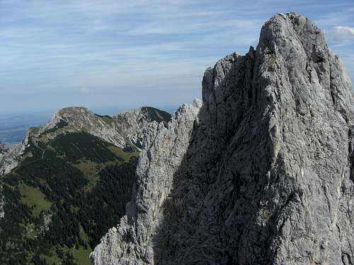
Große Schlicke appearing behind bold Gimpel
As Tannheimer Berge, the easternmost subgroup of Allgäu Alps, is a small, handy and straightforward area, you can dream about summiting each summit within this group – if you be so free to dream such dreams.
For several years I´m trying to fulfill this dream. First you are eager to summit the big shots, as in our case Gehrenspitze, Kellespitze, Rote Flüh, Gimpel and so on. Then there are the – for different reasons - “interesting” summits like Die Schneid, Schartschrofen, Einstein, Aggenstein, Gaichtspitze. The rest is sort of “well, if I have time but no better idea it might be nice to climb Große Schlicke, but …”
How can one be so ignorant and wrong?
Große Schlicke is the highest point of a west – east running ridge, starting at Füssener Jöchl above Tannheimer valley and ending north of Reutte and Pflach / Lech valley. To the south Große Schlicke towers over the beautiful mountain valley of Saba creek (Raintal) to the north there is – yes – the Hundsarschtal (dogs ass valley! don´t ask me why …) and the adjacent Vilser Kegel.
My thought was: not a very interesting peak: no rock climb, not very prominent, lonely and unknown, yes, but only one of those numerous meadow summits, the views to the south are blocked by the Tannheimer main summits, all in all something what I call a “substitute hike”.
The truth is: Große Schlicke is no rock climb, it is a rather prominent peak with excellent views to the north, east, west and, yes, south and to the impressing northern rock walls of the Tannheimer main ridge. It is an easy hiking summit, well known by many hikers (except me….), crowded sometimes, a great hike in late autumn when the sun still heats up the south slopes. You can make a nice traverse to Schartschrofen on a high trail with spectacular views and you have Musau Alm with an excellent cheese dairy, Füssener Hütte and Otto Mayr Hütte for food and lodging.
You just can spend a nice and awesome day on Große Schlicke!
Getting There
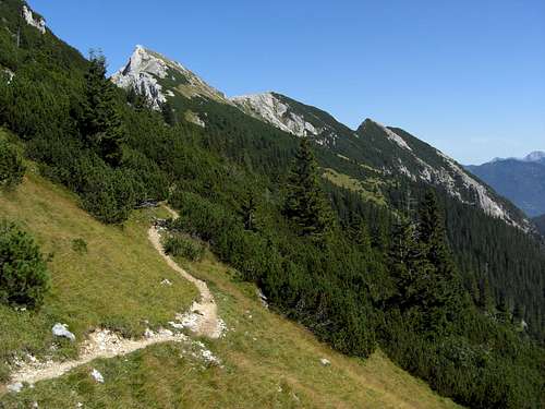
Große Schlicke as seen from Füssener Jöchl trail
Main trailheads for Große Schlicke are
Routes Overview
Vils route
From the Vils parking area at the Fall quarries follow the forest road number 412 to Vilser Alpe. Proceed on trail number 412 until you reach a trail junction. Take the left hand trail (the right one goes up to Füssener Jöchl) which zigzags up to Vilser Scharte. Turn left there and follow trail number 414 up to Große Schlicke.
 Musau route |
 Musau route |
 Musau route, view of Gehrenspitze |
Musau routes
From Musau – Bärenfalle parking area follow the forest road number 413 to Musauer Alm.
Alternatively use the steep trail from Musau railway station to Achsel, the east ridge of Große Schlicke, where a forest road to Musauer Alm starts.
Directly behind Musauer Alm use the trail branching off to the right and ascend to trail number 414 from Füssener Jöchl / Vilser Scharte. Turn right and ascend to Große Schlicke summit.
Alternatively stay on the forest road at Musauer Alm and proceed on that road until you reach Otto Mayer Hütte and Füssener Hütte. Take the right hand trail up to trail number 414 and to Große Schlicke.
Füssener Jöchl route
From the mountain station of Füssener Jöchl use trail number 414 to Raintaljoch, Vilser Scharte and to Große Schlicke.
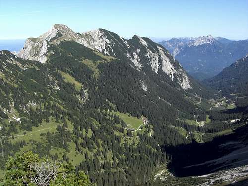
 Füssener and Otto-Mayr-Hütte |
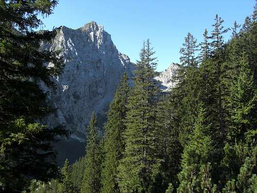
 Raintal and Tannheim north faces |
 Große Schlicke and mountain huts |
You reach Füssener Jöchl
- via cableway from Grän
- via forest road number 412 from Grän – parking area at the cableway valley station
- via forest road and trail number 413 from Haller and Haldensee to Gessenwangalpe, Raintaljoch
- via forest road and trail number 412 from Vils to Vilser Alpe
Red Tape & Accommodation
Red Tape
There are no special restrictions in this area as far as I know.
Accommodation
You find hotels, campgrounds and other accommodation at
Vils
Musau
Reutte/Tirol
Tannheimer Tal (Grän, Haldensee, Haller, Nesselwängle)
 Summit view to the west |
 Summit |
 Summit view to the east |
Mountain huts:
Musauer Alm
Vilser Alm
Otto Mayr Hütte
Füssener Hütte
Gimpelhaus
Tannheimer Hütte
Gear & Mountain Condition
Raintal valley / Musau route
Große Schlicke is a year round summit.
In late spring, summer and autumn it is an easy hikers summit. You need hiking gear and good shoes.
The ski route is an easy one, too, as you use the forest roads until Füssener Hütte and ascend on the gentle south slopes which only get steeper near the summit. In winter and spring you need full ski tour gear and your avalanche gear.
Check the Tirol avalanche bulletin here.
Current Weather:
Maps
Große Schlicke and Raintal valley
Maps
Alpenvereinskarte Bayerische Alpen, scale 1 : 25.000, number BY 5: Tannheimer Berge, Köllenspitze, Gaishorn, with trails and ski tour routes; 1st edition 2012; Deutscher Alpenverein and Landesamt für Vermessung und Geoinformation Bayern
Bayerische Topographische Karte, scale 1 : 50.000, number UK 50-48, Füssen und Umgebung, Landesamt für Vermessung und Geoinformation Bayern