
-
 16633 Hits
-
 85.87% Score
-
 21 Votes
|
|
Mountain/Rock |
|---|---|
|
|
39.15310°N / 117.1739°W |
|
|
Nye |
|
|
Hiking |
|
|
11085 ft / 3379 m |
|
|
Overview
 |
|---|
Consider the Toiyabe Range within the context of Nevada. The Spring Mountains are an urban playground, dotted with trails, ski areas, highways…the state’s sacrificial lamb to man’s urge to explore the wild...on a casual weekend outing close enough to home to still catch dinner and a reality show nightcap after. The Snake Range, perhaps the state’s quintessential range and also the highest which it can truly call its own, lies five hours away, requiring a concerted effort to reach the area, yet its placement within Great Basin National Park makes it a beacon for casual tourists and summit chasers alike. Nearby, the Schell Creek Range runs long and high but lacks a real punch. Perhaps one can claim the Rubies and the East Humboldts as the state’s most rugged, picturesque, and magical range; it’d be hard to dispute that. Yet they seem out of place, a piece of the Sierras scattered hundreds of miles away from their true abode, living an existence as obscure outliers.
Creeping further into the empty interior of the state one discovers the true barrenness of the Great Basin, driving some of the loneliest highways in the country, a designation certainly not limited only to US 50. Take a side trip down US-6 between Ely and Tonopah and marvel at both the lack of people as well as the odd looking rocks that make up the White Pine Range and Currant Peak, yet another unknown classic in the state, as well as the sharp bristleconed ridges of the Grant Range. Between these two highways lie five or so great ranges, all imposing, remote, bare, rugged, and with summits over 10,000, truly emblematic of the state.
 |
|---|
The highest summit here is claimed by Mt. Jefferson in the Toquima Mountains to the east. But viewed from afar the Toquimas look less a continuous range than a series of ridges, the largest and oblong one in the middle being the highest peak within a few hundred miles in any direction. But it is the Toiyabes that catch your eye, whether coming into Austin via US-50 or driving down NV-305 coming down from Battle Mountain. These high, bare peaks loom over the barren steppes of the heart of the Great Basin in an unbroken, continuous chain; close your eyes and you can imagine beneath these giants Mongol hordes, aboriginal tribesmen, or any harbinger you’d wish from a more primitive time. Far from being the state’s highest, or sharpest, or most rugged or picturesque range, I think a claim can be made that they are the state’s most consistent, most fitting, the one range you can always depend on to pack a punch that represents the environs of the state as a whole.
 |
|---|
It is arguably the longest range in the state, though the Schell Creeks may vie for that title. Arc Dome anchors the range at its southern end, an ultra-prominent peak worthy of its unique title, with the popularity befitting that of an ultra and a county highpoint, with at least two great trails leading to its summit, no less. To its east is Toiyabe Dome, arguably the range’s most difficult summit to attain, tantalizing close to the Big Smoky Valley yet requiring a steep and strenuous ascent covering brush, rocks, and sagebrush.
 |
|---|
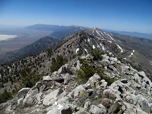
Moving north, the range offers up the consistent and continuous fruits of bare and rocky summits, from French Mountain, to the mostly unnamed peaks leading up to the small town of Kingston. Of the peaks that are officially named, the monikers are appropriately anonymous: South Toiyabe Peak, and Toiyabe Range Peak, the latter sometimes with its elevation accompanying its nondescript label. Bunker Hill is the northern climax of the range, a bulging mound of talus that foreshadows a few more named peaks and with it, traces of human history as the range reaches the highway and the town of Austin. And at the very north, the Toiyabes rise quite anti-climatically to 10,000 ft heights at Mt. Callaghan before fading into the steppes from which it arose.
 |
|---|
Quite a prelude for our peak here, one that isn’t even named, and sits hiding in plain sight between Bunker Hill and the crest of the Range at Toiyabe Dome. It catches notice for some because it rises over 11,000 feet, 25 those extra 85 feet giving it more than the prominence it needs to be counted as one of Nevada’s many 2000 foot prominence peaks. And while I can’t say it would've gotten on my radar were it not for its inclusion on that list, 11,085 is a peak that truly deserves more than just a passing glance.
 |
|---|
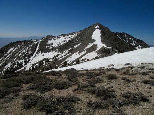
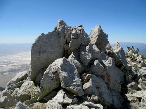
Access is splendid. A good dirt road passable by any passenger car will take you to a reasonable trailhead. From there, you can reach the wonderful Toiyabe Crest Trail spanning the length of the range via a surprisingly well maintained and lush trail. Higher up you will find a steep slope worthy of Nevada standards, and a crowning granite finale: a blocky, rocky summit ridge out of place in middle of the Great Basin and like the Rubies, more befitting a spot in the Sierra Nevadas. You can find plenty of scrambling and rock climbing along the southern ridge, but the true summit can be easily attained via some class 2-3 stuff from the north or the west. And from the summit, views of the entire span of the Toiyabes from its brow, and vistas in every direction near and far.
Getting There
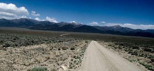
From the junction of US-50 west of Austin and NV-722, I recorded mileage of 6.2 to the first junction. Along the way you drive by an airport. The road leading south to the Reese River Valley between the Toiyabes and the Shoshones isn’t labelled by a name here, but there are signs for Ione Ghost Town and the Berlin-Ichthyosaur State Park. Take a left off the highway (if coming from the east) and drive south for 18.5 miles. The road is paved at first before turning into good graded gravel.After 18.5 miles you arrive at a T junction with a smaller dirt road leading east into the Toiyabe Range. As of June 2014 it is signed with the various drainages accessible via this road, and the sign includes the Washington Creek Drainage. Start re-measuring your distances from here (waypoint approx. N 39.20075 W 117.34980). Stay straight on what looks to be the main road as it quickly crosses a bridge over the Reese River. At 3.5 miles take a left. You will soon see a sign indicating Forest Road 126. This road is a little rougher but still fine for any passenger car. Keep driving and at mile 4.8 take a right on the signed Forest Road 305. The road gets a little rockier near the end. You pass what appears to be shockingly some residential homes in these hills, and suffer through a few bumps before you reach the trailhead at 8.1 miles. As of June 2014, the road looked to be very recently graded, and most passenger cars should be able to make it just before the end of the road. There is a small creek crossing right before the trailhead, but worst case you can turn around and park before the crossing a few yards further than where you need to be.
Note that right before the trailhead you’ll approach an abandoned mining shack. Google Earth shows a sideroad leading left up to some mines, and hypothetically you could’ve started further up in the past, but this road has been walled up and blocked now by the Forest Service and is off limits.
Routes
There are two ways to approach the summit. You can follow the Toiyabe Crest Trail up to a high saddle northwest of the peak, then skirt around the summit of ranked peak 10,683 to hit the north ridge of 11,085. This is about 6 miles one way. The alternative requires more off trail travel but is shorter at 4 miles. Along the Toiyabe Crest Trail, locate the west ridge of the peak and ascend cross country directly to the summit. Both options are around 3,400 feet of gain. One could consider a loop. Both options are described below. |
|---|
Approach
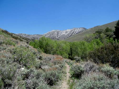
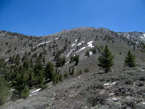
The Topo maps may be inaccurate for the trails here. Ours showed two trails leaving the trailhead, the left branch following the Washington Creek Trail, and the right branch circling southeast before joining up with the Toiyabe Crest Trail (TCT). The latter option would involve more mileage and I would advise against it. The trail, which crosses the creek immediately, is hard to find from the trailhead and isn’t marked. I followed it a bit and noticed that it seemed narrow and overgrown. My conclusion is that this trail is not actively maintained, and the Forest Service instead is routing people to use the Washington Creek trail, which is both maintained and signed.
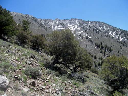
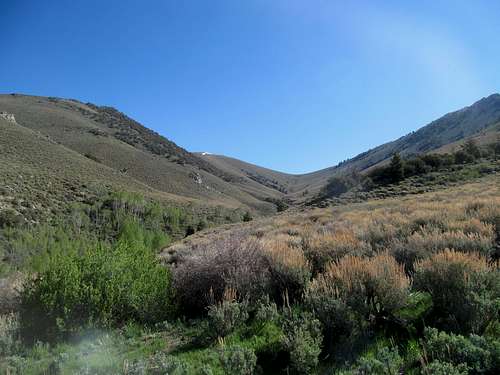
Your topo map may show that the Washington Creek Trail eventually switchbacks south up a ridge and disappears. That is wrong. Some old mining trails may do that, but there actual designated trail follows the creek up to a high meadow where it does indeed provide direct access to the Toiyabe Crest Trail. Both the Washington Creek Trail and the TCT trail are marked with a sign at the left corner of the trailhead. Follow this sign and this good trail as it traces the path of the surprisingly lush creek amid groves of aspen and other trees. Parts of this route is shaded, which is a welcome relief if you’re attempting this peak in the summer.
You will get an occasional good view of the peak as the trail heads east. If you pay close attention to the creek you might notice a cool narrow section where the creek cuts directly through a narrow slot on a granite slab…something you’re more likely to spot in Idaho or Montana. This is easier to spot on your way back.
Eventually the trail will ascend higher and curve northeast, then north, you approach the drainage directly below the western face of the Toiyabe Range crest. You will arrive in an overgrown area where the trail may be occasionally hard to follow. This is where the junction is with the TCT. Look for small signs indicating the latter. If you lose the trail, just follow the creek, and you’ll be sure to meet the TCT further up the drainage because the latter continues to parallel the waterway.
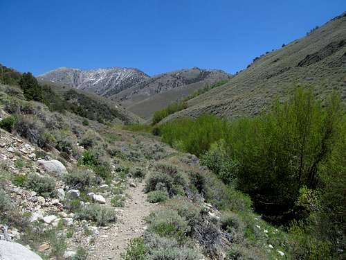 Washington Creek Trail | 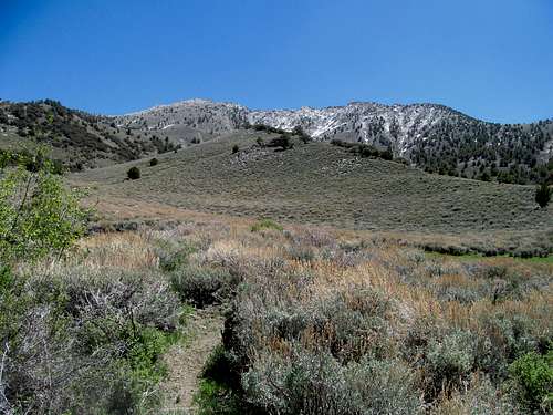 11,085...West Ridge Route on Left |
North Ridge Option
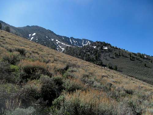
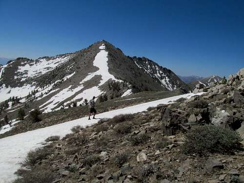
The TCT may be slightly difficult to follow here but isn’t too overgrown. It follows the creek north before switchbacking up the sagebrush slopes and eventually leading to a wide grassy and obvious saddle at the northern head of the drainage at around 9,900 ft. (So if you really lose the trail for some reason, just aim for this saddle). Here, the TCT continues north towards Kingston. You want to take a right and start ascending southeast up a ridge the skirts around the west side of Peak 10,980. Descend to the saddle between it and 11,085, and navigate some narrow brushier areas to the final north ridge of your destination. The easier side seems to be the left side, but at the time of our visit a steep line of snow restricted us to the right side of the ridge, which was steeper and rockier. The granite boulders multiply near the top but you should be able to keep it at class 2 or easy class 3. Hit the blocky summit and enjoy the views.
West Ridge Option
After the Washington Creek Trail junction with the TCT look at your destination peak. The west ridge itself is easy to spot as long as you know what you’re looking for. Note the granite slabs up top and the jagged ridgeline that ends near a rounded bump at the north. That is the highpoint, and the west ridge leads directly down form there.
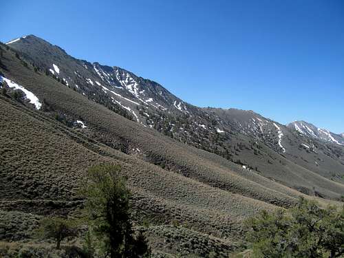
At around 8800 ft (approx. coordinates N 39.15557 W 117.19185 based on Google Earth) the trail borders the Washington Creek wash, and you’ll notice a side drainage coming in from the north east. Above that is the SW flank of the West Ridge, which you should have spotted and noted mentally a half mile back at least. You’ll notice that the line of ascent is blocked a very dense section of sagebrush. I’d recommend continuing on along the trail a little bit past the side drainage, then hitting the ridge in a directly easterly approach or circle up further and hit the ridge from the northwest, where both these aspects of the lower ridge seem less brushy. It’s the first few hundred feet that are the thickest, then easy terrain past there. Reach a small saddle along the ridge at around 9,760 ft. (N 39.15561 W 117.18279). The rest of the ridge is straight forward, and you’ll ascend over 1,300 hundred feet here directly to the summit above you. It gets steep and bouldery near the top, but the terrain is similar in difficulty to the north ridge, and there’s no obstacle that can’t be easily figured out.
I personally liked our loop of ascending the trail and up the North Ridge, and downclimbing the West Ridge. The latter is a very straightforward descent that’s hard to pass up when you’re at the summit, and it’s easier to descend through thick sagebrush than climbing up through it. The North Ridge Route gives you the best unencumbered views of Bunker Hill to the north as well, as the views of this peak at the summit are blocked by the subpeak and high ridges north.
The peak can likely be climbed from NV 376 on the east, but that would probably involve a longer approach, with over 5000 of gain coming up from the desert floor.
Motel lodging is available in nearby Austin. There’s only 3 or so motels in town, so if you don’t call beforehand don’t be surprised if they are all booked by the night you get to town. Expect rates to be mid $50’s and up. There is room for camping at the Washington Creek Trailhead. And plenty of open space for dispersed and car camping. If you have a few days consider combining this peak with Arc Dome, less than an hour to the south. There is a popular forest service campground (Columbine Creek) that serves as the trailhead for the latter peak.
The TCT may be slightly difficult to follow here but isn’t too overgrown. It follows the creek north before switchbacking up the sagebrush slopes and eventually leading to a wide grassy and obvious saddle at the northern head of the drainage at around 9,900 ft. (So if you really lose the trail for some reason, just aim for this saddle). Here, the TCT continues north towards Kingston. You want to take a right and start ascending southeast up a ridge the skirts around the west side of Peak 10,980. Descend to the saddle between it and 11,085, and navigate some narrow brushier areas to the final north ridge of your destination. The easier side seems to be the left side, but at the time of our visit a steep line of snow restricted us to the right side of the ridge, which was steeper and rockier. The granite boulders multiply near the top but you should be able to keep it at class 2 or easy class 3. Hit the blocky summit and enjoy the views.
 Gaining the TCT saddle NW of Peak | 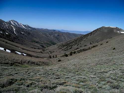 Looking down Wash. Creek Drainage | 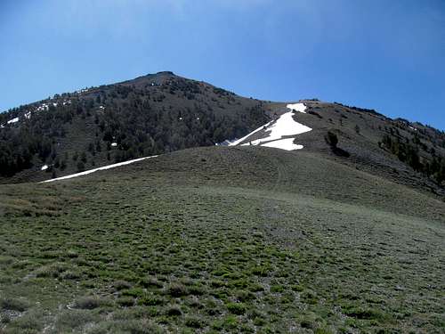 initial ascent from saddle | 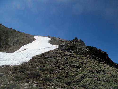 initial climb from saddle | 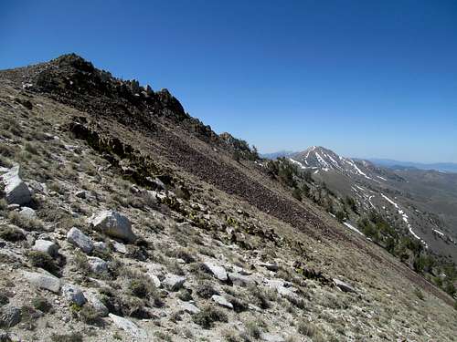 towards the north ridge |
 traversing down to North Ridge | 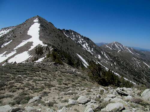 towards North Ridge | 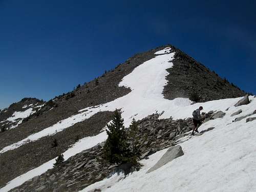 at the saddle | 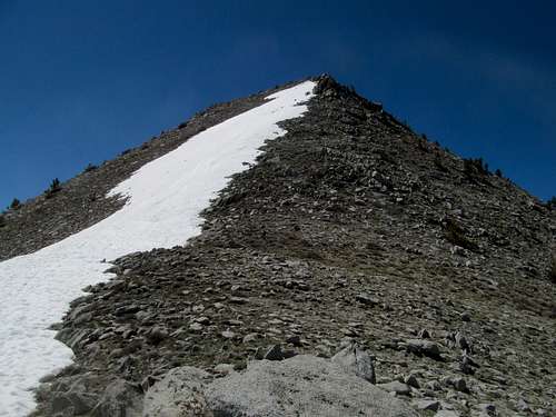 ascending North Ridge | 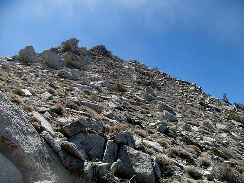 near the summit |
West Ridge Option
After the Washington Creek Trail junction with the TCT look at your destination peak. The west ridge itself is easy to spot as long as you know what you’re looking for. Note the granite slabs up top and the jagged ridgeline that ends near a rounded bump at the north. That is the highpoint, and the west ridge leads directly down form there.
At around 8800 ft (approx. coordinates N 39.15557 W 117.19185 based on Google Earth) the trail borders the Washington Creek wash, and you’ll notice a side drainage coming in from the north east. Above that is the SW flank of the West Ridge, which you should have spotted and noted mentally a half mile back at least. You’ll notice that the line of ascent is blocked a very dense section of sagebrush. I’d recommend continuing on along the trail a little bit past the side drainage, then hitting the ridge in a directly easterly approach or circle up further and hit the ridge from the northwest, where both these aspects of the lower ridge seem less brushy. It’s the first few hundred feet that are the thickest, then easy terrain past there. Reach a small saddle along the ridge at around 9,760 ft. (N 39.15561 W 117.18279). The rest of the ridge is straight forward, and you’ll ascend over 1,300 hundred feet here directly to the summit above you. It gets steep and bouldery near the top, but the terrain is similar in difficulty to the north ridge, and there’s no obstacle that can’t be easily figured out.
 West Ridge from Saddle | 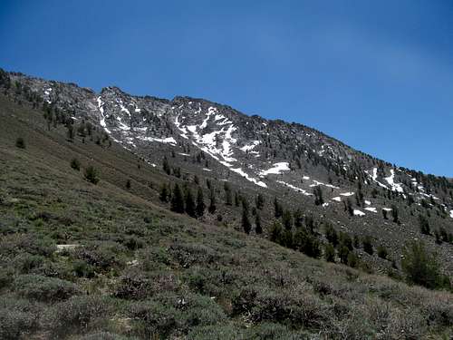 granite ridges south of summit | 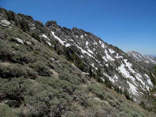 nearing the top | 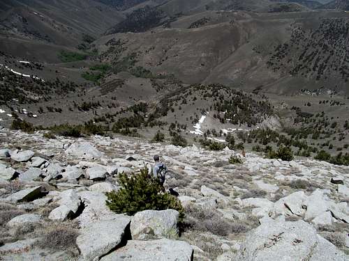 steep terrain near summit | 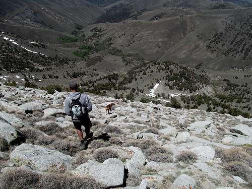 views during descent |
I personally liked our loop of ascending the trail and up the North Ridge, and downclimbing the West Ridge. The latter is a very straightforward descent that’s hard to pass up when you’re at the summit, and it’s easier to descend through thick sagebrush than climbing up through it. The North Ridge Route gives you the best unencumbered views of Bunker Hill to the north as well, as the views of this peak at the summit are blocked by the subpeak and high ridges north.
The peak can likely be climbed from NV 376 on the east, but that would probably involve a longer approach, with over 5000 of gain coming up from the desert floor.
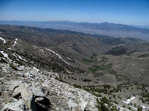
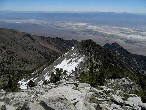
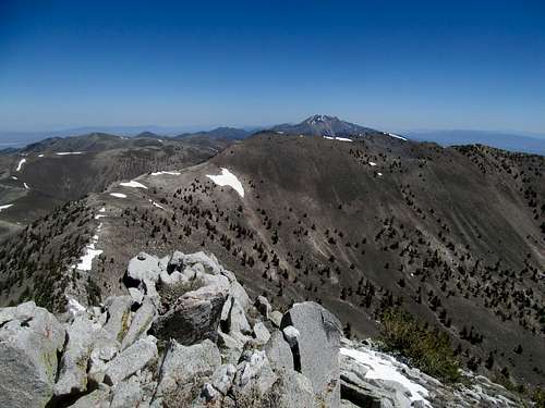
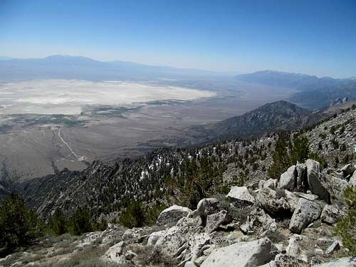
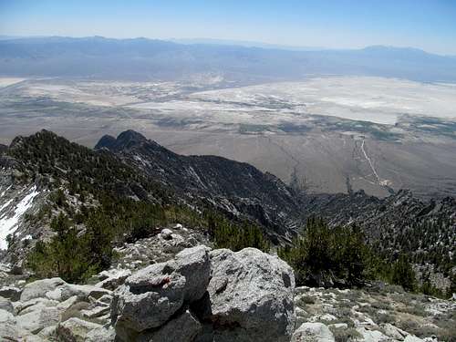
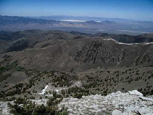
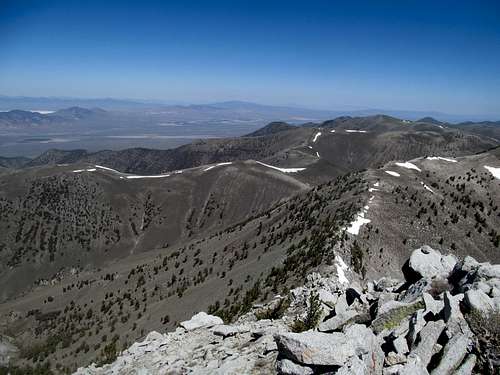
Views
 | 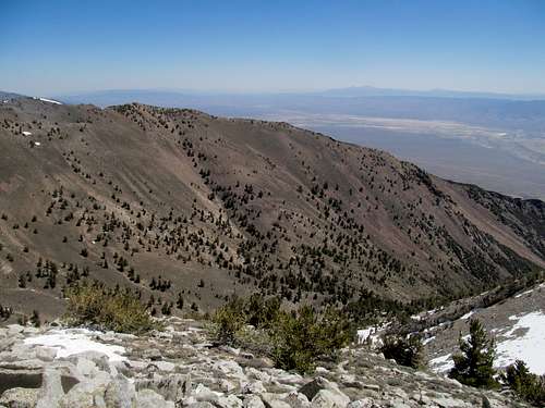 |
|---|---|
 |  |
 |  |
 |  |
 |  |
Et Ceteras
This peak is accessible and less than an hour’s drive from Austin, but still remote. You will not have cell phone service until you reach the ridge crest, if at all. Come prepared, gas up, and tell others where you’re going. Late Spring through fall are the best times to climb this is the best time to climb this peak, depending on snow conditions. Winter might involve a long approach, as I'm not sure how far in the Forest Service maintains these roads, and the steepness of the ascent may require an ice axe and/or crampons. Be wary of tick season in the Great Basin from Spring through early summer.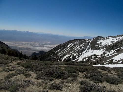 |
|---|
Motel lodging is available in nearby Austin. There’s only 3 or so motels in town, so if you don’t call beforehand don’t be surprised if they are all booked by the night you get to town. Expect rates to be mid $50’s and up. There is room for camping at the Washington Creek Trailhead. And plenty of open space for dispersed and car camping. If you have a few days consider combining this peak with Arc Dome, less than an hour to the south. There is a popular forest service campground (Columbine Creek) that serves as the trailhead for the latter peak.