
-
 8041 Hits
-
 85.87% Score
-
 21 Votes
|
|
Mountain/Rock |
|---|---|
|
|
40.06605°N / 114.87991°W |
|
|
White Pine |
|
|
Hiking |
|
|
Spring, Summer, Fall, Winter |
|
|
10459 ft / 3188 m |
|
|
Overview
|
|---|
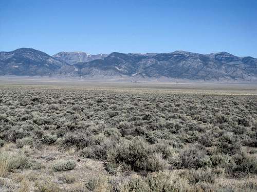
The Cherry Creek Range is a North-South column of mountains in between Wells and Ely in Northeastern Nevada. Though it rises to heights of over 10,500’ and lies right next to US-93 running between the two towns, the range is rarely climbed and can be considered remote by many standards. The range highpoint, the unnamed Cherry Creek Benchmark, lies in the southern half of the range. It is an impressive mountain in its own right, rounded yet ringed with an impressive array of trees and cliffs. Yet though it was an interesting outing I ultimately found the wooded summit unsatisfying in a way, lacking the expansive 360 degree view one selfishly comes to expect out here in the west.
|
|
|---|
Fortunately the Cherry Creek Range offers up other alternatives; one of them, unnamed Pt. 10,459, dominates the northern section of the Range and lies within the recently proclaimed Goshute Canyon Wilderness (not to be confused with the Goshute Range, a separate mountain range some 40 or so miles to the northeast). As graceful as the name/number 10,459 is, for nomenclature purposes I’ll refer to this peak as Snow Creek Peak, for the drainage that lies to its west. Drivers along US-93 and 93-A will unknowingly glance at this gentle giant, with its elongated and bare ridgeline sure to attract some measure of attention from the discerning passerby. The actual summit itself lies near the southern end of the open ridge, and is worth a climb both for the reason that it is the pre-eminent open summit of the range, as well as the fact that it is a soft-ranked Nevada P2K.
|
|
|---|
The peak itself is gentler than the range highpoint to the south, and ascending it will require only the most basic cross country huff and puff up either its eastern or western slopes. There are steep sections, but the rewards from the top are worth the relatively minor effort.
|
|---|
Getting There & Ascent Route(s)
Despite its remoteness this is not the worst peak to access considering some of its P2K alternatives in Nevada.
|
|---|
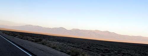
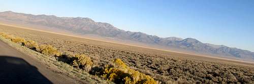
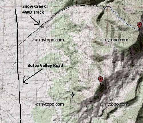
From the South: Drive north from Ely around 44-45 miles to the signed turnoff for the semi-ghost town of Cherry Creek. Take a left and head due west down NV 489 towards the town; this road is paved for 8 miles until you reach Cherry Creek. Drive straight through the town as it turns into gravel and continue west through the canyon as the road rounds the southern end of the range. Navigate the curves of this dirt road as it eventually traverses to the western side of the Range, into the Butte Valley, then turns and heads due north, becoming the Butte Valley Road. Reach a turnoff around 22.1 miles from US-93 (it is around 8 miles to Cherry Creek, then 14 miles through the canyon and up the Butte Valley). You will arrive at an intersection with a dirt road bearing northeast and a large turnoff on your right (east side of the road). 2WD passenger cars can make it easily to this point, and possibly a mile or so further up the dirt road. However the ruts, brush and rock will quickly make the dirt track high clearance only as it goes northeast first then east eventually into the Snow Creek Drainage, getting rougher near the end before it fades. Walking this road in its entirety will add probably around 3 miles each way to the trip and maybe another 700 ft of gain.
 Butte Valley Rd. Butte Valley Rd. |
 Small canyon near 4WD terminus Small canyon near 4WD terminus |
 view of small canyon & 4WD TH view of small canyon & 4WD TH |
|---|
If you are coming from the East (ie Utah/SLC) this is probably the best way to reach the trailhead as well. Take US-93 A from Wendover to its junction with US-93, then south another 14.2 miles to the signed Cherry Creek turnoff for NV-489.
From the North: If you are coming from the west or the north this is probably the best way to go. You can still reach the Cherry Creek ghost town turnoff around 93 miles south of Wells, but there might be a quicker way. Take US-93 south from Wells 47 miles and look for the turnoff for the Butte Valley Road as you drive by the southwestern flanks of massive Spruce Mountain. This road will eventually take you to the Snow Creek Turnoff and will save miles and likely time as opposed to driving south to Cherry Creek and swinging back north.
Snow Creek Peak can be approached from the east too. The Goshute Canyon Road turnoff is maybe 3 to 4 miles south of the turnoff for the Snow Creek drainage. This road looks like it will head northeast towards the Paris Ranch, marked on topo maps, then ascend to Currie Summit, from where it will wander into the Goshute Basin below the peak’s eastern slopes. I have not been on this road so I cannot attest to its fitness or accessibility, but can only assume that at the very least 4WD/high clearance is required. If you can make it this far you can ascend the peak’s east or southeast slopes a very steep 2000 feet or so to the summit through open grassy terrain.
|
|---|
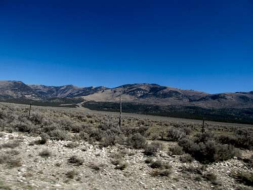
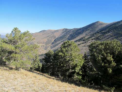
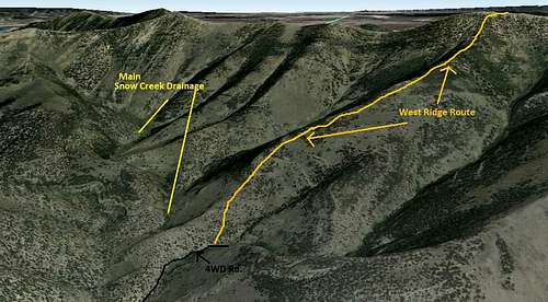
We ascended the direct West (NW) Ridge via the Snow Creek Drainage. Follow the 4WD track via vehicle or foot to its terminus as it disappears in some deep canyons or brush, a little above 7,400 ft. Observe on the map the main Snow Creek Drainage coming in from the north, and how the end of the road is actually a ways past (east) of that confluence, and by now you should be separated from that main drainage by a ridge. This ridge, on your left as you ascend the road, is the beginning of the West (NW) Ridge. Gain it.
Depending on where you begin climbing it may be a little steep at first, but soon the going is easy through open terrain. You might find game trails every once in awhile. In general, the northern side of the ridge will have more trees and be slightly brushier, while the southern side is a little more open. Stick to the crest anyhow as best you can as you pass some minor rock bands around 8,200’. Continue straight up the West Ridge as the bare ridges north of the summit adorn the view to your left. You’ll enter some more wooded terrain around 9,300’, but the grade eases up a bit before racing steeply the last 700 feet or so to the narrow, open summit.
From the end of the 4WD road this fairly quick route would probably be 3-4 miles RT with 3000 feet of gain or so.
 Gaining ridge from 4WD road Gaining ridge from 4WD road |
 Snow Creek Canyon on your left Snow Creek Canyon on your left |
 view of small canyon & 4WD TH view of small canyon & 4WD TH |
|---|---|---|
 Ridges north of peak Ridges north of peak |
 Ridges north of peak Ridges north of peak |
 Right below summit Right below summit |
Alternate Route
An alternative route found by Adam Helman starts higher but requires more 4WD driving to reach the trailhead. Route information via Dean's TR:
Along north-south Butte Valley Road get to this junction at (40.00630° N, 114.95950° W) west of the mountain. Drive northeast to this junction at (40.01230° N, 114.94813° W) and bear right (east) on a lesser road (shown only on the satellite image).
Follow the road into and up a canyon, generally east northeast. A fence is opened and closed soon enough. Reach a key junction at (40.02959° N, 114.89936° W), elevation 7,712 feet.
Here the topo chart shows the left fork only going to a spring. Take that fork nonetheless, the road deteriorating markedly, and proceed to just west of a badly eroded section at (40.03572° N, 114.89555° W) where the "road" climbs around the south flank of a hill. A few hundred yards prior to the undriveable section is the junction with a two-track at (40.03528° N, 114.89722° W), bypassing the eroded section to its south.
Bear right (south) at that junction and drive the track to a parking spot at (40.03897° N, 114.89162° W), elevation 8,308 feet - your trailhead.
(The final track and its junction are only visible on satellite imagery.)
It is 12:38 p.m. when we ascend north to the skyline ridge, topping-out roughly here at (40.04492° N, 114.89445° W), elevation about 9,100 feet.
We contour clockwise to avoid climbing hills to our north, leading to the base of Peak 3177's west southwest ridge. The latter ridge becomes snowy, predictably at around 9,700 feet - and we are again postholing along a summit contour's entire length just as with Telegraph Hill.
We see our goal one-half mile northeast, descending 4 ten meter contours to the intervening saddle under worsening weather. Only about ten minutes are spent on the summit of Peak 3188, our goal, before wind and a light snow suggest an early return. Conditions improve markedly after losing a thousand feet elevation.
Note: you can find all of Adam's Trip report for the trip HERE.
Views
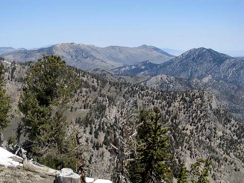
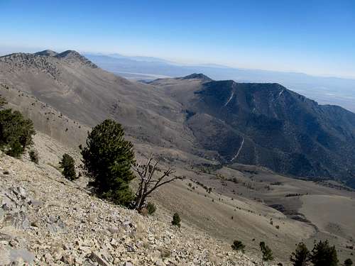
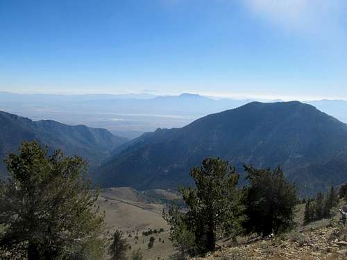
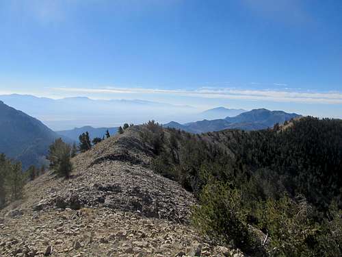
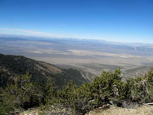
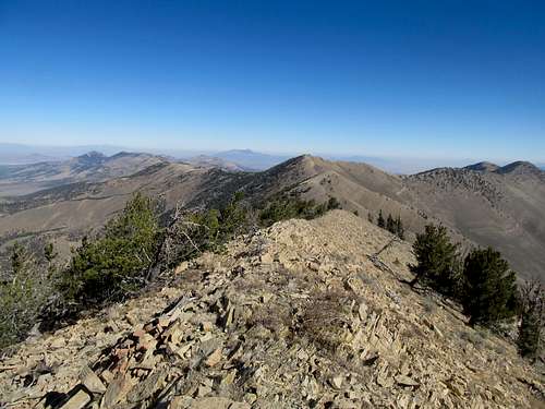
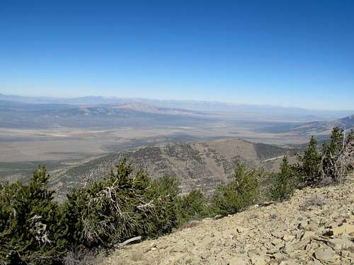
Views are expansive, ranging from Pilot Peak to the northeast, to the Schell Creek Range across the valley and even the Deep Creek Range beyond in Utah. South you can see towards Ely, Mt's Moriah and Wheeler in the distance. West you can expansive views of the entire Ruby Range and then further north the East Humboldt Range. Impressive views of Spruce Mountain round out the panorama.
|
|
|---|---|
|
|
|
|
Etc's. and Links
This is open BLM country with ample opportunities for responsible car camping. The closest motel lodging would be in Ely to the south, Wendover to the northeast, and Wells well to the north. Make sure you have ample gas in the tank as well before leaving any of these towns into the open desert.The peak and most of the routes up are located within the Goshute Canyon Wilderness, and as such all Wilderness regulations (party size, pack animals, lack of motorized equipment, etc.) should be observed.
More information on the Wilderness Area can be found here:
BLM Map
Wilderness.net
Friends of Nevada Wilderness
Apparently there are some caves on the eastern side of the range that offer opportunities for spelunkers and such.