
|
|
Mountain/Rock |
|---|---|
|
|
45.86180°N / 7.87617°E |
|
|
Hiking, Mountaineering, Skiing |
|
|
Spring, Summer, Winter |
|
|
10220 ft / 3115 m |
|
|
Overview
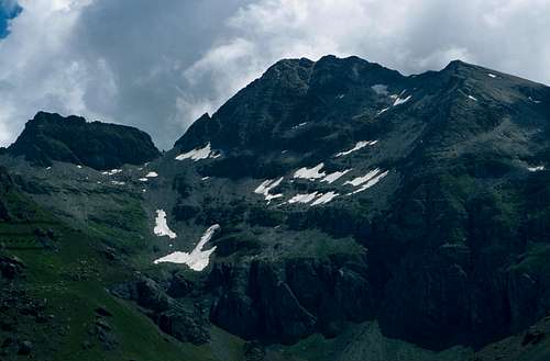
Straling is one of the summits of the big dorsal that from the top of Corno Bianco(3320m) climbs till the iced flanks of Piramide Vincent, the most southern pinnacle of Monte Rosa range, delimiting the watershed between the valley of Lys (Valle D’Aosta) and of Sesia (Piedmont) rivers.From the summit of Straling, two ridges descend along the border line between the two regions: the south ridge, that ends at Coppa Pass under Corno Grosso and the North one, that falls to Civera Pass and then rises again forming a nameless strange summit, with a long and almost horizontal top ridge.
A third ridge descends toward East, entirely in the territory of Piedmont, till the green meadows of Pian Misura.
The first ascent to Straling is dated back to 1820 by a team guided by Giovanni Gnifetti, priest of Alagna and first climber of Signal Kuppe(or Punta Gnifetti, 4556m), the highest summit of Monte Rosa facing Valsesia.
From the top of Straling you can enjoy a large view,from Monviso to Pizzo Bernina, passing by Monte Bianco, Grand Combin, Monte Rosa and all the other important summits of Valle D’Aosta and Valsesia.
NE face of Punta Straling
Getting there
The nearest village From the side of Piedmont is Alagna in Valsesia.To get there by car follow the highway A26 (Milano-Genova) till the exit of Romagnano, then go on along the main road of Valsesia till the end of the valley.
The trailhead in Val D'Aosta is instead the village of Gressoney, located in the valley of Lys river and easy reachable from the Point Saint Martin exit of the Highway Torino-Aosta following then the main road of Lys Valley.
Huts
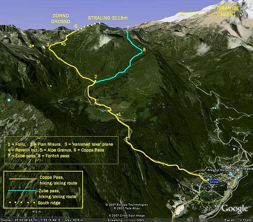
The only useful hut on the side of Piedmont is Bivacco Ravelli(2500m) in Otro Valley.The trail to Ravelli starts directly from Alagna and crosses the beautiful valley passing by the Walzer villages of Follu and Scarpia.
After the small alpine settlement called PianMisura, the signed path enters the canyon of Rio Cuttiri and finally reaches the hut, on the summit of a pinnacle on the hydrographic right of the river(south).
From the side of Valle D'Aosta there is instead the Hut near the Gabiet lake, at 2300m, that can be used as trailhead to reach Coppa pass, along the normal route.
The hut is quickly reachable from the village by the chair-lift open all the year.
Routes, hiking and mountaineering
South ridge, from Alagna. F(I, II UIAA scale)The normal route from Alagna through the valley of Otro is very long, with an elevation gain of 2000 meters, but the place is one of the most beautiful of the area and it surely deserves a visit.
The initial part of the trail is the same of the one that ascends to Ravelli hut (that can be used to brake in two day this long hiking), but under the pinnacle over which the hut is built, from a plane called “of the vanished lake”, you have to hike toward NW, to reach Alpe Granus, a small settlement.
From Granus go on scrambling over the lovely green meadows, in the direction of Corno Grosso, the most prominent summit between Straling and Corno Bianco.
When you get in the wide cirque below the east face of Corno Grosso, often covered by snow even during summer, hike toward W, to enter in the steep gully that climbs to the narrow saddle of Coppa Pass, on the right of a small pinnacle.
From the pass, follow entirely the wide south ridge, till the south summit(3020m). Go down for 30 meters, to reach the saddle under the south summit, and, finally, climb the last part of the ridge, that is very narrow, with some passages on rock evaluated as I and II degree of UIAA scale.
After two false summits you reach the highest point at 3115m.
South ridge, from Gressoney. F(I, II)
The normal route from Gressoney starts from the impound of Gabiet Lake, at 2375 meters, where you can arrive by a cable-lift from the village.
From the impounds hike toward East in a wide rocky colouir that ends at Coppa pass.
From here follow the same route described before.
N ridge (AD+, III with some IV).
This ridge is made of rocks not always firm and often covered by lichens, it starts at Civera pass and goes up for 250 meters.
It’s rarely climbed.
To get to Civera pass you can start both from Alagna or from Gabiet, following the trails to Zube pass, at the end of the ridge.
Routes, ski-mountaineering
The slopes of straling are fantastic for free-riding and ski-mountaineering.The most frequented routes are those of Coppa Pass, following the normal route to the summit, and the one of Zube Pass.
Zube is located at north of the nameless summit formed by the N ridge of Straling, after Civera pass.
Normally skiers ascend to Zube from the Gabiet Lake, on the side of Val D'Aosta, for descending then to Foritch pass(Valsesia side) along the fantastic slopes under the NE face.
From Forich pass, the route continues towards south reaching the Walzer villages of Pian Misura and Follu in the Valley of Otro, and then Alagna.
External Links
The following links are usefull to get informations about the accomodation, the roads, the lifts and the trails.Alagna home page
Gressoney home page
Punta Straling from Gressoney valley(W)