
-
 2280 Hits
-
 74.01% Score
-
 4 Votes
|
|
Route |
|---|---|
|
|
36.62855°N / 118.3212°W |
|
|
Trad Climbing |
|
|
Summer |
|
|
A few days |
|
|
5.9 (YDS) |
|
|
11 |
|
|
IV |
|
|
Overview/Approach

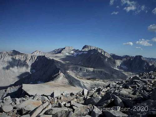
Mount Barnard is the highest 13er in the US (12th highest peak in California). It stands at 13,996 and was included as a 14er until remeasurements were taken at some point. It is situated just north of Mt. Whitney and from its summit (easy to reach after climbing the East Face route), you get an extraordinary back side (northwest) view of Mt. Whitney and Mount Russell. You can actually hike between Barnard and Whitney on the highest plateau in the lower 48.
The East Face climb is one of legend, first climbed in 1972 by Galen Rowell and Tim Auger. This is the only published route on this mountain as of 2020. Its guarded access (approach and climb cover almost 8000’ from car to summit) and the challenge of the climb compared to Mt. Whitney’s routes for example, make it an enduro challenge for most. The trailhead for Mt. Whitney by comparison starts 2000’ higher and both the hiker and climber trails on Whitney are well established. In comparision, as of 2020, you will not find much of an established trail up to Mt. Barnard. That being said, this is the Sierra and any bushwhack along the east side pales in comparison to Canadian and Alaska objectives for example. Once you did the approach one time, you would no doubt find it much easier going if (for whatever crazy reason) you returned. I made it in 5hrs my first go up and 3hrs on return with a two-night pack at age 57, but I am fit. The climbing day itself is not overly daunting. The approach and descent from the tarn are rather straight forward but do burn calories. It is relatively easy to find the start of the climb and with exception to the final two pitches (easily combined), staying on route was not overly challenging using David Nettle’s hand written topo, again, with exception to the final “corner” pitch(s).

There are two obvious corners at the top of the face in the direction of the climb. The one on the left is what should be sought after. It is an incredible looking dihedral: large and tall, looks to be mostly hands, slightly overhung possibly, right facing. The next one to the right, is a right facing multi-dimensional corner, the one I thought we were to climb. However, it is mostly a closed and moss choked corner. I started up it anyway only to back off. To summarize, the final two pitches of the climb are not well described on Nettle’s topo or on MP.com. Rather, the third and correct option is to the east of the beforementioned corners and starts out as a perfect hands splitter. You do stem your left foot to a shallow corner out left, but it starts out as more of an in-face crack climb than corner climb. You traverse right to a hidden orange colored corner that finishes to the top. In any regard, this final 200’ is not a continuous or obvious corner system you can make out from below. From a large comfortable ledge below, I led this pitch with a 70m to a slung horn on a large block on top. Belaying from the large ledge is the way to go, stealing part of the end of pitch 9 (as laid out in the topo) and combining pitches 10 and 11, and making one lead out of it.
The approach is heinous compared to 99% of Eastern Sierra approaches. If you learned to climb in Canada or Alaska as I did, it is just another day at the park. But I could not recommend this climb to most lower 48 climbers I know. The drive is best done with a vehicle with clearance or it might be faster walking the roads which bask in 100F heat during the summer months. From US395 the turnoff is unmarked but is located just north of the LA aqueduct between the towns of Independence and Lone Pine. From the north the turnoff is 7.5 miles from the post office in Independence. The right-hand turn is on a paved road on the west side of 395 and there is a crossing at the median for northbound traffic. You head south across a cattle guard and turn right on a dirt road. At .7 miles turn left and cross an old wooden bridge (2020) across George Creek and turn right. Keep straight on this road as it parallels the south side of the creek for over a mile. Turn right across a cement under-bridge (water rolls over it). Continue straight on this road as it parallels a fence line on your right. Just over another mile there are two roads on your left heading due west. The 2nd one was marked in 2020 as a USFS …S03. Either one is fine as they merge in short order. Then make a long and slow drive over 5 miles heading west on a deteriorating road which comes to a T intersection. Turn left to reconnect with George Creek in short order. A decent vehicle can make it to a singular parking spot on the left side of the road just before you reach the creek. The road continues for another 100 yards +/- but it would be hard to turn around right at the creek. I did not time it but you can assume this drive takes approximately an hour from 395 depending on what kind of vehicle you are driving.
Elevation at George Creek where you start your approach is 6350+/-. After the climb, you are essentially topping out at just below 14,000’. The approach itself is approximately 7 miles long. Don’t get too caught up in approach beta regarding when to cross the creek and meander back and forth through deadfall, brush, and cliffs. The idea is to find the path of least resistance which changes with floods, etc. In 2020, we found that if you start on the north side of the creek and bushwhack through some downed trees and brush, up a sandy slope, you can access a human trail for a short period before crossing to the south for a better one. Sometimes there are numerous cairns, sometimes not. You come to a waterfall at a narrow point in the canyon, but it is easy 5th class up two steps on the south side without having to cross the creek. An obstacle that does bar travel on the south side is a blank cliff wall that comes down into the creek. In August the water was high enough to force us to cross back over to the north and then immediately back to the south. This area is heavily vegetated. You then navigate large downed trees by walking atop them and following a trail here and there on the south side. At this point, you commit to the south side for the duration. The trail starts to rise and at times is almost half way between the cliffs above and the creek below. It dips to the creek on several occasions as they both gain elevation which allows you to gain water.
Eventually, the trail angles southwest away from George Creek as it aims for Carl Heller Creek which is located in a perpendicular canyon (running south to north) to George Creek. The trail becomes the easiest to follow during your entire approach as it leads you to an easy crossing of Carl Heller Creek. There is a well-used bivy site on the west side of the creek. Angle back northwest to ascend a steep sage covered hill. At the top of this hill you enter trees and slabs back southwest to avoid heavy brush along the upper George Creek. You can’t go to far south as the cliffs will stop you. Ascend pleasant open forest all the way to the talus fields coming down from the tarn you will camp at below your objective. Hike several remaining steep talus fields to the origin of George Creek, a small tarn with a good-sized sandy beach on its north shore. One single man bivy was nicely established at the northeast corner of the tarn at its outlet, with tons of additional flat and soft camping.
Morning of the climb is straight forward. You have to circumvent Shaw Spire which impedes the view of your objective. It is best to access a north to south ramp at the west end of the tarn and cut back right aiming for a small col on Shaw Spire's upper ridge line. Once you reach this notch, the east face will come into full view (photo provided). Angle northwest to the base of the obvious whitish slab with black streaks above. It took us approximately an hour to reach the base of the climb from camp.
Route Description
1st Pitch- 200’-5.7/ Start at the apex of the talus below the white slab. Meander up intermittent cracks and corners trending up and right to a ledge just below some overhangs with the start of a gully up and left. Nothing remarkable but fun climbing at the grade.
2nd and 3rd Pitches- 240’-5.8/ Instead of entering the gully up and left as MP.com or the topo suggests, better and more direct climbing angles up and right to the base of pitch 4 which is a slung block (2020) on a large ledge below a pillar with corners on both sides.
4th Pitch- 150’-5.8/ Climb the left side of the pillar to its top. Traverse right into twin cracks and then trend back left, traversing straight left at one point, below roofs above, to a stance/small ledge below a left facing corner.
5th Pitch- 130’-5.8/ Stem up the corner to a comfortable belay.
6th Pitch- 130’-5.9/ Continue up the left facing corner stemming and jamming, by-passing the large block atop the corner to the right via a short and steep crack section (5.9). Belay comfortably on top of the block.
7th Pitch- 115’-5.7/ Continue up another left facing corner which bleeds out right to avoid a massive flat block above, into cracks that lead to a large ledge.
8th and 9th Pitches- 200’-5.9/ Climb straight up cracks to what the topo refers to a “squared slot” (recess) with a ledge. Continue up trending left over the arete and climb steep exposed cracks to a ledge. The steep ground after the arete is 5.9 climbing on the topo. MP.com has this pitch as 5.8. I suspect there are multiple variations, I followed the topo (5.9) and this steep and exposed section on the left side of the arete is as much of a crux to the route as any other. Makes no sense to split these pitches up, rather after the 5.9 section, continue to a wide ledge below a massive corner.
10th and 11th Pitches- 230’-5.9/ There is a massive right facing corner system up and left but that is not the route (I tried it!). Rather finish the 9th pitch by wandering up 5.7 cracks up and right to access a perfect hands splitter on low angled ground. Stem out from time to time to a shallow right facing corner. Traverse right (crux) to a colorful deep right facing corner and finish the route to the top of the face with a perfect horn to sling off of on a large boulder.
An easy ridge hike leads to the summit of the peak with stellar views of Mt. Whitney and Mt. Russell to the south.
Climbing Sequence
|
|

|

|

|

|
Descent
Hike down large talus angling northeast. Just above the low point of this upper hanging drainage, descend down fast and soft ground constantly angling back southeast towards the tarn. This remaining ground offers fast ski like descent, with intermittent talus.
Essential Gear
The topo calls for a double rack to #3 and a #4. I took single to # 3, double to #1 and we always had plenty of gear. If I did it again, I would drop the extra #1 as well. Helmets a must, a ton of loose rock. Route receives full day sun with the exception of some of the corners. Biner approach shoes. No water from the tarn up to the base of the route. There is some water on descent before you reach the tarn again. For the approach, hiking poles and waterproof approach shoes. Black flies in August were a pain for the first hour in and last hour out.