
-
 5562 Hits
-
 84.82% Score
-
 19 Votes
|
|
Mountain/Rock |
|---|---|
|
|
47.15183°N / 12.13845°E |
|
|
Hiking, Scrambling, Skiing |
|
|
Spring, Summer, Fall |
|
|
9334 ft / 2845 m |
|
|
Overview
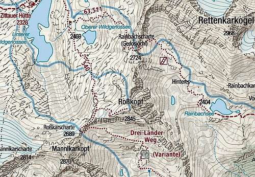
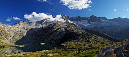
The summit rises in a strong ridge which goes from Reichenspitze first towards the north-east and then towards the north (Wildkarspitze ridge). Southwest of Rosskopf there is a bit higher summit of Mannlkarkopf, 2870 m, then comes the Rosskarscharte (notch), 2689 m, then Rosskopf, 2845 m, where the ridge turns towards the north. There we find the next notch, called Rainbachscharte (also Gerlosjoechl), 2724 m, beyond which with the Hoher Schafkopf, 3057 m, the narrow massif of Wildkarspitze begins.
On the northwestern side of Rosskopf lies the end of the beautiful Wildgerslostal (valley). South of the summit lies the high valley of Rainbach, which is the side valley of the long Krimmler Achental. Through these valleys the approaches on Rosskopf come.
Finally, it is worth mentioning a few nice lakes around the Rosskopf summit. The ponds on the east and south (Rainbachsee and Rosskarlacke) are small, but on the northwest the two lakes, named Wildgerlossee can be found. Especially the lower (Unterer) one is big and very beautiful. Just above it the popular Zittauer Huette (hut) stands.
What To Do There?
Rosskopf is in summer/autumn exclusively a hikers mountain and in winter/spring a tour skiing mountain. In addition to the marked paths, coming up from the valleys, there is also a marked path, which connects Zittauer Huette with Richterhuette (and from there crosses further the slopes of Reichenspitze group).Summit Views
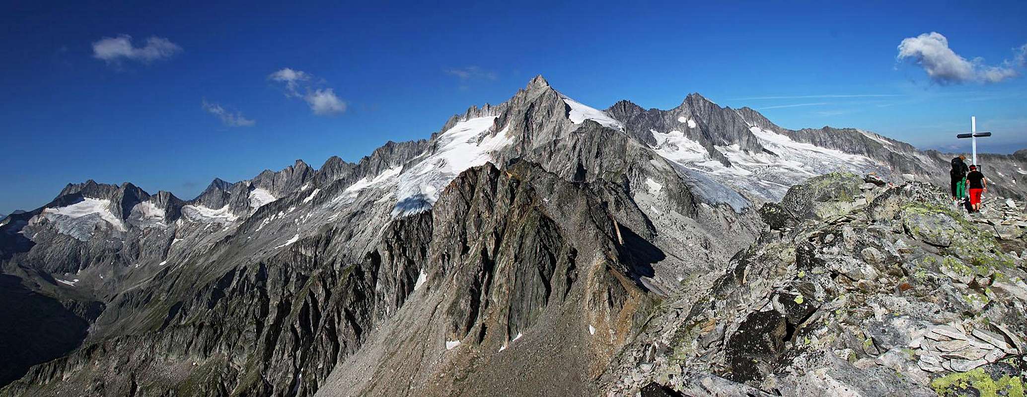
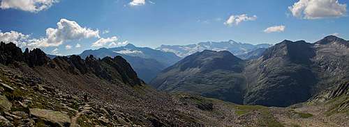
Reichenbachspitze group
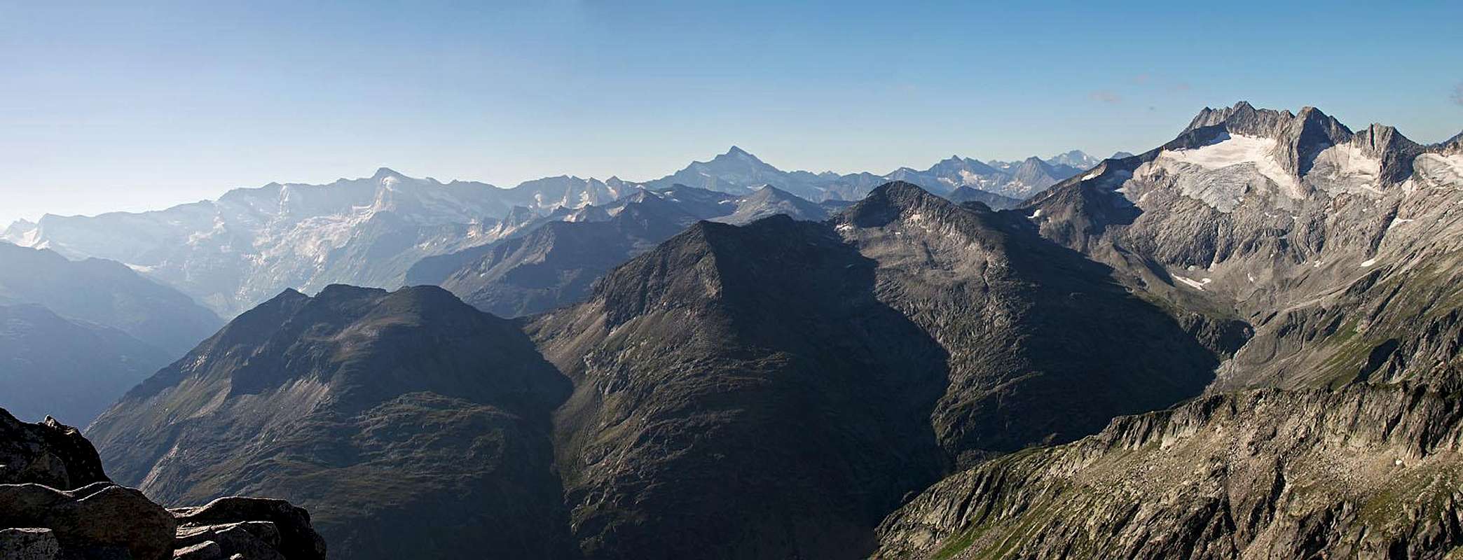
Towards the SW

The summit

The view northwards
Getting There
Rosskopf is mostly ascended from the northwest, from the Wildgerlostal. The last parking place in the valley is at Finkau, 1420 m. The road further to the valley end is then closed for public trafic. So, there's the most common start of the tour on Rosskopf, unles you are coming from further away.From the other side, from Krimmler Achental, only few people ascend Rosskopf. Even that famous valley is closed for public traffic, but hut busses and taxis are driving into it. The ascent on Rosskopf could start at the famous Krimmler Tauernhaus, 1631 m.
Ascent Routes
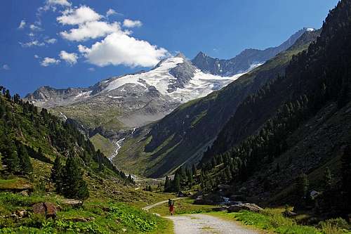
Wildgerlostal

By the waterfall
1. From Finkau via Zittauer Huette
The first part of the ascent would be a bit boring, if the Wildgerlostal would not be so beautiful. As the valley is quite flat, cosider using till the valley end a mountain bike! From Finkau parking place the road continues up the valley and first overcomes a 150 m high valley step. Don't go there by the road, because along the creek a beautiful marked path goes. In the next 30 minutes you will visit a beautiful gorge, called Leitenkammerklamm, which was recently proclaimed a natural monument. Then the path exits again on the road, and you reach Trisslalm, 1584 m. From there you first continue by the road, then do a shortcut by a marked path and then till the valley end go by the road. So, you reach Im Grund, 1888 m, where at the lower station of material cable way the road ends. The plate says you have till Zittauer Huette 1 h of walk, but it's 450 m of elevation gain, so adjust expectations.
The marked path continues in many comfortable switchbacks southwards. When it approaches the steep rocky step with a waterfall, it gets protected by cables. Over there the path is very steep, but still broad and without any difficulties. Above the step the path gains a distinct ridge, from which you have a nice view on the Reichenspitze glacier (Wildgerloskees). An explanation table teaches you about its size changes. Then you continue the ascent southwards, but soon the path turns eastwards, towards the hut. By interesting plates it crosses the creek and then ascends over the last bumps towards the big hut. With the big lake and views on Reichenspitze it is a wonderful place to rest.
Reichenspitze from Zittauer Huette

Towards Rosskarscharte
The summit ascent is all the time easy (T2). From Finkau 4 h 30 min, from Zittauer Huette 1 h 45 min.

At Rosskarlacke

Descending towards Rosskarlacke
2. From Richterhuette
This is a long distance hut-to-hut trekking option, usually done in the opposite direction. The hut lies on 2374 m and can be quickest (in good 2 h) reached from the Krimmler Tauernhaus through the valley of Rainbach. Actually, the crossing to Zittauer Huette starts below Richterhuette, in the valley end, by the lower station of material cable car. So, unless comming by the valley up, we first descend those 200 m. On 2185 m (Keesboeden) the marked path crosses the creek and starts crossing the broad slopes towards the northeast. The path is called Peter-Obholzer-Weg or also Drei-Laender-Weg. The path soon starts ascending the steep slopes of a distinct ridge, descending into the Rainbach valley from Mannlkarkopf. It soon gets narrow, but is well beaten. When we are around the ridge, there is already the small pond of Rosskarlacke, 2293 m. There again the view on Rosskopf opens.
Descending into the high valley of Rosskar
Also this ascent is easy (T2). From Richterhuette 3 h.

Rainbach valley
3. From Krimmler Tauernhaus
This route connects Krimmler Tauernhaus with Zittauer Huette, going over the Rainbachscharte. This hike is more demanding than the previous two routes, but I have no personal experience with it. From Krimmler Tauernhaus you first go by the road into the valley of Rainbach, but soon (on some 840 m) this marked path deters right up. It gains a lot of altitude, then crosses the high valley to Rainbachsee, 2404 m, and continues northwestwards. Before the notch, there is one protected, more demanding passage, then the path reaches the notch, 2724 m. Going on the summit of Rosskopf only by marked paths, you would now need first to descend down to the crossroads at the Oberer Wildgerlossee, 2469 m, which means a big loss of altitude. But supposedly you can also follow the main ridge (or just below it) from the notch on top. It only requires some easy scrambling and climbing over the blocks. 4 h from the hut.
Mountain Huts
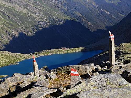
Unterer Gerlossee and Zittauer Huette
1. Krimmler Tauernhaus, 1630 m, southeast of Rosskopf. This is one of the most famous mountain huts in Alps, which got its fame in the last centuries, supporting trade and smuggling over the high Tauern passes. From Krimml you reach it in 2 h (along the famous waterfalls), but regularly also a hut taxi drives there.
2. Richterhuette, 2374 m, south of Rosskopf. This house supports trekkings and also harder climbs in the Reichenspitze group. From Krimmler Tauernhaus it can be reached in good 2 h, from Krimml in 4 h.
3. Zittauer Huette, 2328 m, northwest of Rosskopf. This house supports trekkings and also harder climbs in the Reichenspitze group. From Finkau parking place it can be reached in good 2 h 30 min.
Red Tape

Life on 2650 m
The roads in both valleys, Krimmler Achental and Wildgerlostal, are payable. Actually, into the first one you can't drive, up there only hut busses and taxis go, while with the Wildgerlostal it's different. You pay already the main road, connecting over Gerlospass Krimml and Mayrhofen. But from that road (from Gerlospass) you can then drive into Wildgerlostal till Finkau hut.
Payable is also the path along the famous Krimml water falls. Even if you are returning from the mountains, below at the exit you are asked for a ticket.
When To Ascend?
| Rosskopf is mostly visited in dry seasons, so during summer and autumn. When conditions are good for tour skiing (spring) it's a nice goal for that recreation as well. But check how eventually the huts are opened. | Click for weather forecast |