
-
 35717 Hits
-
 83.09% Score
-
 16 Votes
|
|
Route |
|---|---|
|
|
43.15310°N / 122.0658°W |
|
|
Scrambling |
|
|
Spring, Summer, Fall, Winter |
|
|
Half a day |
|
|
Scramble/Technical Climb |
|
|
Class 4 |
|
|
1 |
|
|
I |
|
|
Approach
The trailhead is located on the east side of Route 138 just north of Crater Lake. From the I-5 Corridor, you can take Highway 138 from exit 124 in Roseburg, Oregon about 80 miles east to the trailhead.
From Medford in the south, you would take Highway 62 about 58 miles north to the junctions with Highway 230. Take 230 north/east to where it meets Highway 138 and turn left. From there it is just north 1.4 miles to the trailhead on the right.
From the east (Bend), you would take Highway 97 south to Hwy 138. Take 138 west about 20 miles to the trailhead.
Northwest Forest Pass required at the trailhead in the Summer. Sno-Park permit required in Winter.
Route Description
The first 1.4 miles is pretty flat gaining only 400 feet. At 1.4 miles you will arrive at a junction with the Spruce Ridge Trail heading off left. Ignore that and continue on 2.4 miles through the forest gaining another 1500 or so feet and arrive at the junction with the Pacific Crest Trail at 7350 feet.
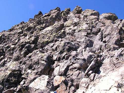
From here the trail becomes a climbers path and starts to climb the ridge. Many paths weave in and out of the trees low on the ridge. Stick mostly to the ridge and don't get too far down on the right. The path steepens and comes out of the trees. Here is a good shot of the ridge as you come above treeline.
As you approach the summit pinnacle, stay to the right to ascend a gully on the SW side of the pinnacle. Don't worry, it's pretty obvious where you have to be. The hike will change to a Class 2 and 3 scramble here. Here is a shot of the gully from the west base of it. And here is one from a bit further lower and to the SW. Aim for the notch on the bottom right of the summit pinnacle in that shot.
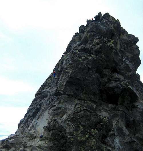
Arriving at the notch at the southeast side of the pinnacle, you can see the 80 foot climb/scramble up the south face.
The route actually is getting worn into the rock in spots so you can see where you need to go but mostly, pick the easiest way up. The start is right in the notch and you angle slightly left as you climb. There may be a couple Class 4 moves with exposure but the rock is fairly solid and blocky (always test your hand and footholds first!).
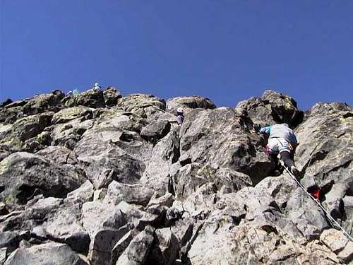
A shot of a Mazama group and the line they took
Most don't protect it but it all depends on your comfort level. It's easy to rap so if you feel better protecting and rapping, by all means do as a slip could mean injury or death. Avoid getting too close to the right side of the south face, the exposure and drop is severe and the wind frequently whips through there.
Here is a shot taken from the edge of the notch just a bit above the above photo and it better shows the angle and scale you will be dealing with.
There is (or was) a summit register to sign at top. Descend the same route. Total distance is about 5 miles trailhead to summit with just under 3800 feet of elevation gain. Probably 5 to 8 hours round trip depending on your individual speed.
Essential Gear
If you are comfortable on Class 3/4, you probably would not want a rope. Many parties do protect it though and if you wish to, a few chocks/stoppers and maybe some long slings to sling horns would be what you would want. Don't forget webbing and rap rings too.
There is no water on the route so take all you need in with you.

If climbing it in Winter, you'd want crampons, two tools, nuts/chocks, pickets and possibly some ice screws depending on conditions. Although with a south-facing climb, I would not count on the ice. The road to the trailhead is plowed in the Winter.If you have information about this route that doesn't pertain to any of the other sections, please add it here.