
-
 9519 Hits
-
 83.69% Score
-
 17 Votes
|
|
List |
|---|---|
|
|
Why This List
Routes can and should be described on separate pages, I know. But that is worth doing only for major routes, which need a description. However, there are many simple tours which are described on mountain or area pages with one or two sentences. But they might still be a goal for a nice day. So here I would like to name the majority of them on one place and give also some basic info about each.
Rating The Ski Tours
Normal Ski Tours
The rating scale for 'normal', non-alpinistic or recreative ski tours is the following one:
1 - Easy. Roads, less steep slopes, 'no' danger to get hurt.
2 - Medium hard. Medium steep slopes, good knowledge of skiing needed, falling or sliding still not fatal.
3 - Hard. Steep slopes, exposed places, very good technique of skiing needed. Falling or sliding could be fatal.
4 - Very hard. Slopes steeper than 40 degrees, exposed places require absolute reliability.
Alpinistic Ski Tours
The scale for alpinistic ski tours overlaps with the above recreative scale in the lower 4 categories. It has the overall rating and the rating of the hardest (specific) details. Categories can have the upper (+) or the lower (-) boundary.
a. Details Scale
S1 - Paths, roads, flat slopes
S2 - Medium steep, broad slopes
S3 - Up to 40 deg. steep, already exposed slopes
S4 - Up to 45 deg. steep, exposed slopes, hard passages
S5 - Up to 55 deg. steep slopes or less, if very exposed
S6 - Steeper slopes than 50 deg., exposed, very hard details
S7 - Extreme difficulties, jumps over rocks or ice cascades, steeper than 50 deg.
b. Overall Scale
F - Easy (Facile)
PD - Less difficult (Peu Difficile)
AD - Quite difficult (Assez Difficile)
D - Difficult (Difficile - 45 deg. couloir of 400 meters altitude difference)
TD - Very difficult (Très Difficile)
ED - Extraordinary difficult also for the best alpinistic skiers (Extrêmement Difficile)
EX - Extremely difficult (abominablement difficile)
The Character of the Group

From Veliki Draski vrh
Triglav Group is the highest part of Julian Alps, which are famous by their wild, rugged rocky walls. But the southern and eastern slopes of these mountains are often also appropriate for skiing. The slopes above Krma valley, Velo polje and the mountains above Pokljuka plateau are very popular for ski tours.
In good conditions here is the list of all trailheads - when roads are cleaned of snow:
> Pokljuka, Rudno polje, 1347m,
> Pokljuka, Javornik alpine meadow, 1300m,
> Bohinj, Voje valley, 700m,
> Krma valley, 1000m,
> Kot valley, Lengarjev rovt (meadow), 900m,
> Vrata valley, Aljazev dom, 1015m.
Ski Tours List
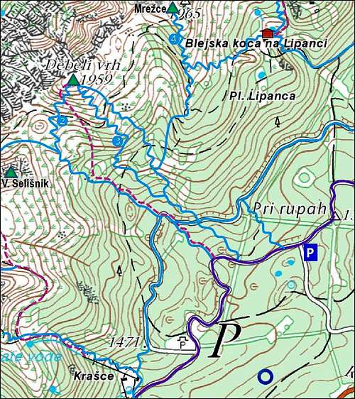
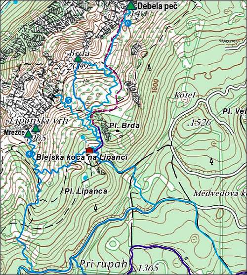
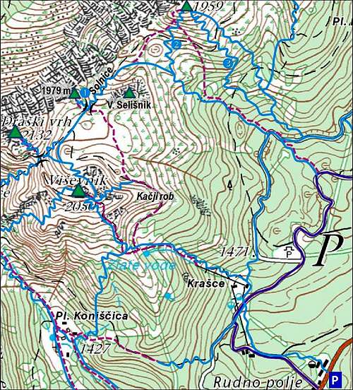
Pokljuka crest
The NE (lower) part of Pokljuka crest offers a few nice, easy to medium hard ski tours. Due to good access - the road on Pokljuka plateau is almost allways cleaned - they are very popular. In addition the offer also great views on Triglav massif from the east. If roads north of the main Pokljuka road are not cleaned, you have to Javornik meadow additional 30 minutes of walk.
 |
 |
|
Summit/ Highest point
|
Ski Tour
|
Alt. diff.
|
Ascent hrs
|
Grade
|
Comment
|
|
Debela pec, 2014m
|
To Javornik meadow
|
720m
|
2:30h
|
2 - medium
|
Through woods to Lipanca, then a steep step and finally up and down by the crest.
|
| Lipanska vrata, 1898m | To Javornik meadow | 600m | 2:00h | 1 - easy | Through woods to Lipanca, then by a valley to the saddle (a steeper upper part). |
| Mrezce, 1940m | To Javornik meadow | 640m | 2:00h | 2 - medium | Through woods to Lipanca, then a steep step and finally a perfect (S) roof to the top. |
| Debeli vrh, 1962m | To Rudno polje | 630m | 2:15h | 2 - medium | By a forrest road, then through steep woods and nice upper (SW) slopes. |
| Debeli vrh, 1962m | To Rudno polje | 630m | 2:15h | 2 - medium | From the valley between Selišnik and Debeli vrh you soon cross right around the SE ridge of the latter and then on top. |
| Veliki Selisnik, 1979m | To Rudno polje | 640m | 2:15h | 2 - medium | Ascent below Visevnik (from the S), downhill through Solnice valley. |
Alpinistic Ski Tours
> Debela pec - Brda: Grapa ob Trapezu (IV, one passage S5-),
> Zapiralka (V, details of S6, below S4),
> Zimski vihar (V-, places of S6-).
 Debela pec |
 Javornik meadow |
 Debeli vrh |
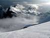
 Mood |
Draski vrhovi
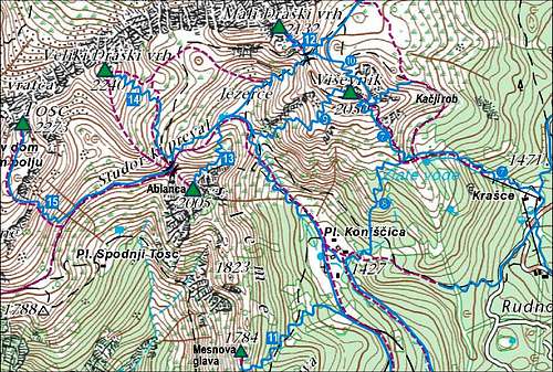
Tosc, Veliki Draski vrh, Mali Draski vrh, Ablanca and Visevnik form a nice group of summits, which are very appropriate and popular for tour skiing. But downhills from all of them are not just easy, actually the hardest ones are already alpinistic descents. Rising immediately above Rudno polje (big parking place), Visevnik is most often ascended. But the most beautiful classics is the ski tour from Veliki Draski vrh.
 |
 |
|
Summit/ Highest point
|
Ski Tour
|
Alt. diff.
|
Ascent hrs
|
Grade
|
Comment
|
|
Visevnik, 2050m
|
To Rudno polje
|
700m
|
2:00h
|
2 - medium
|
By ordinary ski slopes, to the SE ridge and by it (at the end very steep) to the top
|
|
Visevnik, 2050m
|
700m
|
2:00h
|
3 - hard
|
Ascent by the SE slope, downhill over the ridge into the NE slope, back over Kacji rob.
|
|
|
Visevnik, 2050m
|
To Konjscica meadow
|
700m
|
2:00h
|
2 - medium
|
Ascent by the SE slope, downhill by the S slope to Konjscica and back (1 more h).
|
| Visevnik, 2050m | To Jezerce |
700m |
2:00h (+1 h) |
4 - very hard |
Ascent by the SE slope, downhill by the NW ravine and back via Konjscica or Srenjski preval (250m up); or further to other goals.
|
| Mali Draski vrh, 2132m | To Rudno polje | 800m | 2:30h | 5 - alpinistic | Around the N face of Visevnik to Srenjski preval, 1959m (easy till here), up by the S slope (very steep, exposed!). |
| Veliki Draski vrh, 2243m | To Rudno polje | 950m | 3:30h | 2 - medium | The route: Konjscica - Jezerce - Studorski preval - top. Very beautiful tour! |
| Ablanca, 2004m | To Rudno polje | 700m | 3:00h | 3 - hard | Not a typical ski summit. We best ski down by the E ridge, ascent possible also from Studorski preval. |
| Tosc, 2275m | To Rudno polje | 1050m | 4:30h | 3 - hard | Long, because we need to go over Studorski preval. Steep S ravine. |
Alpinistic Ski Tours
> Ablanca: Gamsova grapa (IV-, one detail S5-),
> Ablanca: Južna grapa (S Ravine) (III, one detail S4),
> Ablanca: Vzhodni greben (E Ridge) (III),
> Mali Draski vrh: South slope (III+, S4+),
> Tosc: Direktna rokavicka (V),
> Tosc: Ravine in the E slope (III),
> Visevnik: Desna grapa (Right ravine) (III+, one passage S4),
> Visevnik: Central ravine in the S face (III+, places of S4+),
> Visevnik: North ravine (III, S4).
 Draski vrh |
 Draski vrh |
 Uskovnica |
 Mali Draski vrh |
 Mali Draski vrh |
Krma valley tours
Krma valley is very long and flat in its bottom part. Between Rjavina massif and Draski vrhovi walls come close together - this is the area, which is in unstable conditions most dangerous for big avalanches. Above the eastern slopes of Triglav, Kredarica and Rz begin. They are very appropriate for skiing, although some parts are very steep. Also here you are not safe of avalanches.
Usually the road is cleaned to the altitude of 1000m, but it is often hard to find a parking place there. There are more at Kovinarska koca, 870m.
|
Summit/ Highest point
|
Ski Tour
|
Alt. diff.
|
Ascent hrs
|
Grade
|
Comment
|
|
Bohinjska vratca, 1979m
|
Krma valley
|
1000m
|
3:00h
|
2 - medium
|
By the bottom of the valley, then steeply up to the saddle.
|
|
Kredarica hut, 2515m
|
1520m
|
4:30h
|
2 - medium
|
Very popular, great ski tour! For Triglav summit you need a complete winter equipment. From Zgornja Krma you have 3 variants.
|
|
| Dovska vratca, 2254m | Into Krma valley | 1250m | 4:00h | 2 - medium | Very nice! Over this saddle you can come over from Stanic hut. Same ascent as fro Kredarica, above through Apnenica valley. |
Alpinistic Ski Tours
> Rjavina (Mala Rjavina): SE slopes (IV, 40-45°, exposed).
 In Krma valley |
 Below Kredarica |
 Bohinjska vratca |
Velo polje
Velska dolina (valley) stretches in the SW part of Triglav group in a E-W direction. It finishes above on the high plateau of Hribarice, cca 2400m. The highlight of this area is Kanjavec, the highest 'real' ski summit of Julian Alps. South of Velska dolina there is a similar Miseljska dolina - also appropriate for skiing, but less popular. Miselj vrh, 2350m, is not mentioned in the table. It can not be reached by skis to the top, the ski tour from its ridge would be very steep. Miseljski konec, 2464m, would perhaps be possible with skis (to Velska dolina), but this would be a pure alpinistic endeavor.
Remark: Coming down to Velo polje, you are not 'at home' yet. You need to find a passage down to Bohinj valley, or, most usual, over Bohinjska vratca, 1979m (see the table above), into Krma valley, where probably your car is waiting. So, altitude differences and hours in the table below are ment only from Velo polje.
|
Summit
|
Ski Tour
|
Alt. diff.
|
Ascent hrs
|
Grade
|
Comment
|
|
Kanjavec, 2569m
|
To Velo polje
|
850m
|
2:30h
|
2 - medium
|
By the valley to Hribarice plateau and on top.
|
|
Kanjavec, 2569m
|
Through Miseljska dolina
|
850m
|
3:00h
|
3 - hard
|
By Miseljska dolina to Hribarice plateau (very steep) and on top.
|
| Dolic pass, 2151m | To Velo polje | 450m | 1:30h | 1 - easy | Almost till the end of Velska dolina, then towards the N on pass |
|
Za Planjo, 2556m
|
To Velo polje
|
850m
|
2:30h
|
2 - medium
|
2km by Velska dolina, then towards the N and around Smarjetna glava to the highest point.
|
|
Planika hut, 2408m
|
To Velo polje
|
710m
|
2:30h
|
3 - hard
|
1km by Velska dolina, then on Konjsko sedlo (saddle) and to the hut.
|
Alpinistic Ski Tours
> Kanjavec: Aerotik (VI-, detail S6+).
 On Dolic |
 Miselj vrh |
 Kanjavec |
Kot valley
The shortest of the three northern valleys of Triglav group is also appropriate for tour skiing, but the tour is quite hard and less popular.
|
Summit
|
Ski Tour
|
Alt. diff.
|
Ascent hrs
|
Grade
|
Comment
|
|
Stanic hut, 2332m
|
Into Kot valley
|
1350m
|
4:00h
|
3 - hard
|
Up below the N wall of Rjavina. Above Stanic hut also possible to go on Zgornja Vrbanova spica.
|
 Kot valley |
Vrata valley
Vrata is the most beautiful valley in Julian Alps. But in winter and spring the areas below the huge Triglav North wall can be dangerous. In the Triglav group there are not many ski tours, leading down to Vrata. Actually, only the tour through the valley behind Cmir is in the top rank. Over the North face of Triglav, through Slovenska grapa (ravine), skiing was also done, but it's a pure alpinistic endeavor. And so, I must mention also that Triglav himself has been done with skis - the biggest problems are on the summit ridge, but also the descent from the shoulder on Triglav glacier is very steep and exposed above. Again only for alpinistic skiers!
|
Summit
|
Ski Tour
|
Alt. diff.
|
Ascent hrs
|
Grade
|
Comment
|
|
Luknja pass, 1758m
|
To Aljazev dom
|
750m
|
2:30h
|
2 - medium
|
Below the N wall of Triglav. Ascent possible also by the northern trail.
|
|
Kredarica hut, 2515m
|
1500m
|
4:30h
|
2 - medium
|
Through woods into Za Cmirom valley and up by it (steep at the end). Then below Rz to Kredarica. Nice tour!
|
|
|
Begunjski vrh, 2461m
|
To Stanic hut and Za Cmirom
|
1450m
|
4:00h
|
4 - very hard
|
The top 20 meters are extremely exposed!
|
|
Cmir, 2393m
|
Into Za Cmirom valley
|
1390m
|
3:30h
|
4 - very hard
|
On dangerous, slanted plates there's a big danger of avalanches!
|
Alpinistic Ski Tours
> Cmir: Uroševa grapa (Uros Ravine) (IV+, details of S5),
> Mali Triglav: Južne vesine (S slopes) (V-, 45°, passages 50°, exposed),
> Triglav: Gorjanska (VI),
> Triglav: From the summit on the glacier (V, one place S6),
> Triglav: From the summit on the glacier - to Kugy's ledge start (V, one place S6),
> Triglav: NE face, from the ridge on glacier(IV+, places S5),
> Slovenska smer (Slovenian Route over the N face) (VI),
> Triglav: From the summit on the glacier and over Prag route in Vrata (V, one place S6, passages S4),
> Visoka Vrbanova spica: Into Za Cmirom basin (III, one place S4).
 From Kredarica |
 Rjavina |
 Za Cmirom |
Interactive map
| See full screen |
Map legend: So far we listed only some most important ski routes. On the map left there are all (drawn in blue) - only alpinistic ski routes (of difficulties TD and higher) are excluded. Use mouse to explore it. Left below we see Velo polje (valley) and the routes ascending northwards. Right below is the valley of Krma, by which we reach the meadow of Polje and then go up northwards in many directions. The 4 huts around Triglav can be connected also with skis, but only few people have such a goal. Then we have summits. One some of them (in the near neighbourhood of Triglav) are ski touring goals. Triglav itself and Rjavina are diffucult alpinistic ski goals, and some other minor summits even can't be skied down. So, many ski tours are starting at mountain huts which are positioned on high altitudes. We see the following clusters of ski tours:
|
External Links
1. Marijana & Marko personal page