-
 15223 Hits
-
 72.08% Score
-
 2 Votes
|
|
Route |
|---|---|
|
|
37.28870°N / 106.5709°W |
|
|
Hike |
|
|
Half a day |
|
|
Walk-up - Class 1 |
|
|
Approach
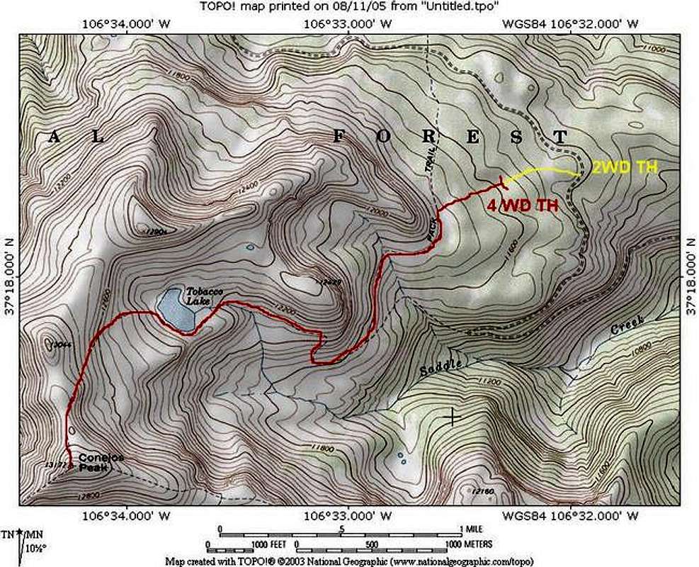
Conejos Peak is located in southern Colorado near the old mining town of Platoro. From Antonito, Colorado, drive west on Highway 17 for 23 miles until reaching Forest Service road 250. Here, there will be a small sign which says "Platoro". Turn right (north) on FS 250 and drive on this dirt road for 17 miles until reaching an intersection with a sign that says "Lake Fork Ranch" and pointing to the west. Zero-out your trip odometer. Turn left (west) on a well-maintained dirt road. After a half-mile (.5), a turn-off and sign for "Lake Fork Ranch" is passed on the right. Continue straight. At 4.2 miles a "Y" is reached. Go left at the "Y". At 6.0 miles, the trailhead for trail 720 is reached. Continue until 7.0 miles where the sign for "Tobacco Lake Trailhead" is reached. Turn left on a very rough road and continue for a half-mile to the trailhead. This final half-mile is somewhat rough. A sturdy 2WD SUV or better is recommended. Low-clearance passenger cars are not recommended for the last half-mile. The trailhead is at 11,600 ft.NOTE: The 1/24 quad (USGS map below) does not show the final half-mile road to the trailhead. In fact, the trailhead and the first part of the trail on the map is incorrect. I have drawn the correct route below.
Route Description
From the parking area at 11,600 ft:A trailhead sign greets you as you begin hiking down a well-established trail through the grass. The trail gradually climbs through small conifer and eventually enters a forest on a ridge. The trail in the forest is muddy, wide, and well-worn due to horse traffic. After the forested ridge, cross "Cow Meadow" where cattle are sometimes seen. After the meadow the trail reaches a gate. Please secure the gate after passing through. The trail then drops down into a small drainage and continues to descend a little until reaching a fork at one mile. Take the right fork and begin a climb up to Tobacco Lake. At the lake you will see a sub-peak directly to the west with a cairn on the top. Conejos is the peak to the far left of the sub-peak with a large cairn and stick on the summit. Once at the lake, skirt around the south side among the boulders. In early season, a skirt around the south side of the lake may be hindered by snow. Stay on the rocks if possible to avoid mud. On the SW side of the lake, ascend the slope above the lake. Here the trail fades in and out; however, large cairns are available to guide the way. The cairns are really not needed in that the route is obvious. Hopefully, the cairns prevent people from making new trails across the tundra. Ascend the lower slopes of the summit ridge. Cross the ridge and climb the last steep section to the summit. Descend your route. As a bonus, hike a little north over to point 13,044 and enjoy views of Platoro Reservoir.