
-
 6198 Hits
-
 93.35% Score
-
 42 Votes
|
|
Mountain/Rock |
|---|---|
|
|
40.26004°N / 9.42543°E |
|
|
Sardinia |
|
|
Hiking, Trad Climbing, Scrambling |
|
|
Spring, Summer, Fall |
|
|
4341 ft / 1323 m |
|
|
Overview
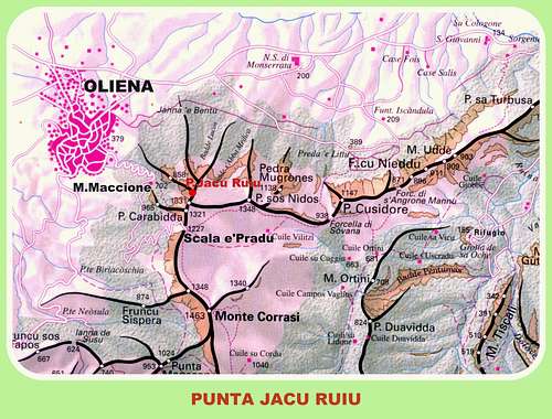
Geographical classification: Sardegna - Sardinia > Supramonte > Punta Jacu Ruiu
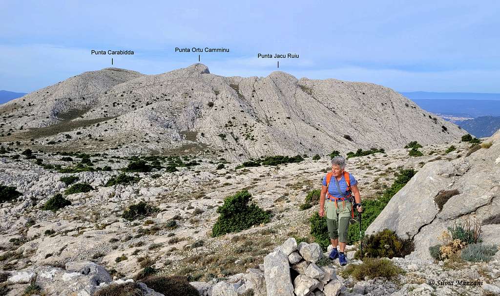
Punta Jacu Ruiu m. 1323
The suggestive Punta Jacu Ruiu is a fine limestone peak lying to the NE of Punta Carabidda and Punta Ortu Camminu belonging to the Supramonte di Oliena, the Western part of the Supramonte Massif, one of the best climbing and hiking destination in Sardinia, situated in the North-East of the island. The peak is lying to the NE of Punta Carabidda and Punta Ortu Camminu on the long ridge starting from Monte Corrasi 1463 m, the highest peak in the whole massif, and running in the South-North direction. Nearby Punta Jacu Ruiu this ridge changes direction with a sharp turn, running in the West-East direction toward Punta Cusidore, Punta Bruncu Nieddu and Monte Uddè and getting to the source of Su Cologone. This ridge divides the Valley of Cedrino to the North from the Valley of Lanaitto to the South. Punta Jacu Ruiu magnificent and complex 180 meters high WSW face, overlooking the town of Oliena, cut by different parallel chimney-cracks, is one of the best destination in this area. This face offers a superb climb on the magnificent first-class limestone of the route “Sbarre di Nebbia”.
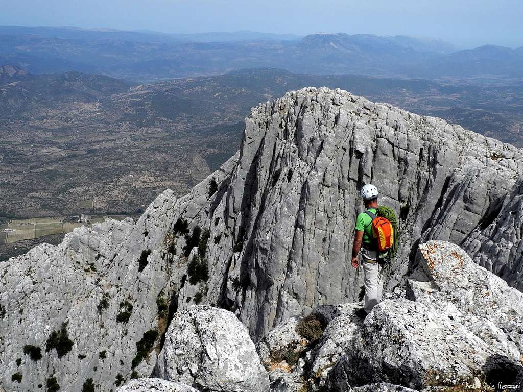
West-South-West Face of Punta Jacu Ruiu seen from Punta Ortu Camminu
Getting There
Access to the island
The great and superb island of Sardinia doesn’t show any problem to be approached; it can be reached by plane or by ferry-boat both from Livorno and Civitavecchia ports. The most convenient destination in Sardinia to visit the Supramonte area, one of the wildest region of the island, is the airport of Olbia if you’re getting there by plane; the same Olbia or the near Golfo Aranci port if you’re getting there by ferry-boat.

Road approach
From Olbia or Golfo Aranci, situated just a few kilometers North from Olbia, follow the quick Motorway SS131 towards Nuoro and Siniscola, exit Lula. From here head towards Dorgali on the road SP 38 and about 5 km. before reaching the town of Dorgali turn to right towards Oliena m. 379. Enter the town and follow the surfaced road to the Monte Maccione Hut m. 644; here the road becomes unsurfaced and impressive, rising with several hairpins to the wide saddle of Scala ‘e Pradu m. 1127, the best approach to the Supramonte karst tableland.
Punta Jacu Ruiu Normal Route from Scala ‘e Pradu
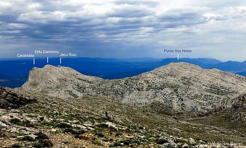
Supramonte Karst tableland seen from P. Jacu Ruiu |
View from Monte Corrasi |
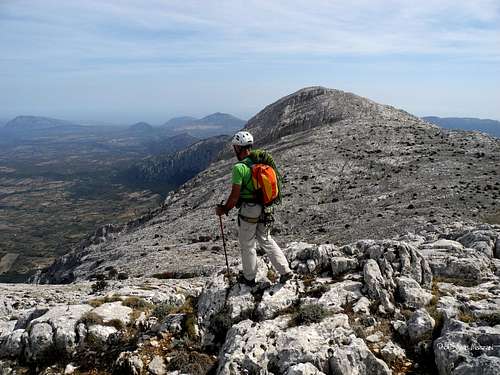
From the wide saddle of Scala‘e Pradu an easy and short walk on the SW ridge, then along the beautiful carved rocks of the high karst tableland, leads to the summit of Punta Jacu Ruiu, across the neighbouring Punta Carabidda and Punta Ortu Camminu. From the summit the hiker can enjoy a superb view over Oliena and its valley and farther away over the town of Nuoro.
Walking access to WSW and W faces routes.
Same approach as for the following route (Sbarre di Nebbia)
All the routes of Punta Jacu Ruiu (UIAA scale)
West-South-West face and West face
- Sbarre di Nebbia (Bars of Fog) III, IV, V 200 m.
- I fantasmi del passato (The ghosts of the past)VII 220 m
- Fiamme Gialle IV, V, VI-, A1, A2 210 m.
- Petite ètoile (Small star) VII- 190 m
- West face and West Ridge II, III 230 m.
Sbarre di Nebbia (Bars of Fog) report
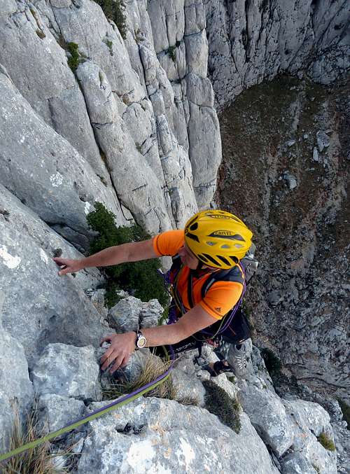
Superb limestone on Sbarre di Nebbia
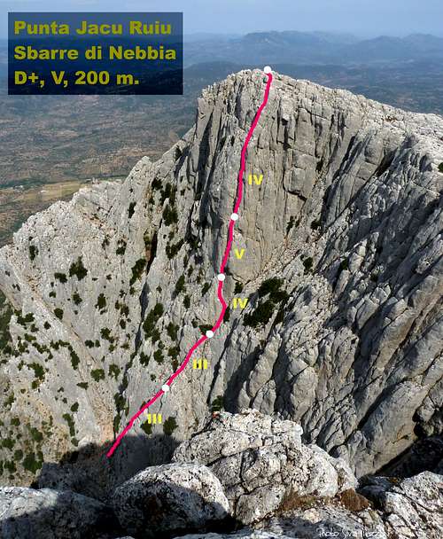
Sbarre di Nebbia topo
Sbarre di Nebbia (Bars of Fog) report (UIAA scale)
Summit altitude: m. 1323
Difficulty: D+, max V UIAA
Climbing length: 200 m.
Exposure: WSW
Equipment: not equipped
First ascent: Alessandro Gogna and Monica Mazzucchi 21-4-1981
Starting point: hairpin on the road to Pedra e’Scala Col
Not so long, but spectacular route on excellent limestone. The climb, running on a steep wall in the upper part, follows the beautiful crack lying in the right hand side of the face.
Approach: from Oliena take the forestal road to the Coop. ENIS Monte Maccione Hut m. 644; after getting to the hut continue towards Scala ‘e Pradu on the road now becoming unsurfaced. Park the car at a shape hairpin towards right, nearby some huge trees, just below Punta Carabidda. Cairn. A track starts from the hairpin heading towards Punta Carabidda; without getting to the bottom of the W ridge of Punta Carabidda carry on along the wild track, skirting the walls of Punta Carabidda and Punta Ortu Camminu, and involving some easy climbing. At a narrow notch down climb and enter a steep and wide gully rising towards the unmistakable wall, now well visible and showing its obvious parallel chimney cracks.
L1 and L2 – Climb a crack slanting right. II, III, m.100
L3 – Climb a corner on its right face, then follows a cracks’ system leading to an edge. Climb it and come back inside the corner near a flake. Belay under a characteristic tree situated at the bottom end of the chimney-crack giving the upper climbing-line. IV, 30 m.
L4 – Climb the overhang entering the chimney-crack. IV, V, 20 m.
L5 – Up the chimney-crack with superb climb, IV, 50 m.
Descent: from the summit of Punta Jacu Ruiu follow the high karst tableland toward Punta Ortu Camminu and Punta Carabidda (South), then the trail leading to Scala e’ Pradu Col. From here follow the gravel road to the starting hairpin (20 minutes from the summit)
Red Tape
No particulary restrictions in hiking and climbing inside this area.
All the Supramonte Massif is lying inside the Parco Nazionale del Gennargentu e del Golfo di Orosei. The wild territory of the park belongs to the Nuoro, Ogliastra and Cagliari provinces and had been established in 1998. Its 73.935 hectares' extension includes 18 communes: Aritzo (NU), Arzana (OG), Baunei (OG), Belvi (NU), Desulo (NU), Dorgali (NU), Fonni (NU), Gadoni (NU), Gairo (OG), Oliena (NU), Orgosolo (NU), Seui (OG), Seulo (CA), Talana (OG), Tonara (NU), Urzulei (OG), Ussassai (OG), Villagrande Strisaili (OG).

|

|
Climate
The mild climate of the island allows the climb all around the year, though South faces are always too hot in summer. Sometimes the NW winds (maestrale) may be a problem.
Meteo
Where to stay
- Monte Maccione Hut above Oliena
- Hotel Su Gologone between Oliena and Dorgali
When to climb and hike
It’s possible to climb all around the year on Punta Racu Jucu, but the best season goes from April to November.
Guidebooks and maps
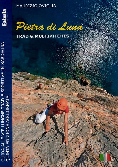 |
Pietra di Luna - Trad & Multipitches
Maurizio Oviglia
Trad and sport multipitch guidebook - V updated edition
Fabula 2015
|
 |
Sardegna
Maurizio Oviglia
Guida dei Monti d'Italia
Club Alpino Italiano - Touring Club Italiano 1997
|