
|
|
Mountain/Rock |
|---|---|
|
|
46.29215°N / 8.82339°E |
|
|
Hiking, Mountaineering |
|
|
Spring, Summer, Fall |
|
|
7549 ft / 2301 m |
|
|
Overview

Poncione d'Alnasca

Summit Cross

Fopia (2106m), part of d'Alnasca ridge
Poncione d'Alnasca is a beautiful summit in one of the most wild and rugged places of Switzerland. It is located in the Val Verzasca, which is a part of the Ticino Kanton. Poncione d'Alnasca is a very remarkable mountain with it's beautiful steep summit pyramid. The ascend of this peak is graded T4 and is a nice day-tour.
The summit of Poncione d'Alnasca in marked by a huge and beautiful summit cross. Furthermore, the views from the summit are very worthwile. To the north, other wild peaks of the region can be seen; like for example Monte Zuchhero (2735m) and Madom Gross (2745m) Towards the west you will see Madom da Sgiof (2265m) and behind that the white peaks with eternal snow of the Monte Rosa Group.Towards the south you can look trough the whole Verzasca valley and even Lago di Vogorno, Verzasca's barrier lake, is visible.
The height difference between starting point and summit is over 1500 meters and the ascent can be marked as quite enduring.If you have a reasonable endurance level and you plan on visiting the Verzasca area, you should definetely head for Poncione d'Alnasca and you will enjoy this great mountainous area for sure!
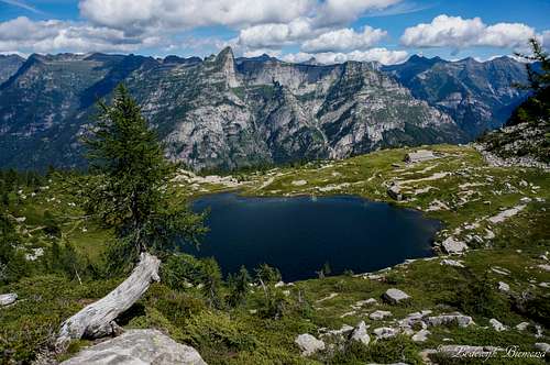
Poncione d'Alnasca at left with Lago di Starlaresc in front
Route
Normal RouteThe trail starts close to the village of Brione (756m) and is graded T4. Just north of Brione (less than a km) lays the village of Alnasca at 757meters. In the center of the village is a crossing of 4 trails. Take the one that goes east and you are on the right track to the summit of Poncione d'Alnasca.
The very well marked trail soon leads into the forest. At Pianchetta you will come across a crossing of trails. Take the trail that goes left. You will pass point 1116 and eventually reach In Cuna Alle Piode (1535m). The route leads on while passing Aggazoi 1876m (south of you).
From this point on you are out of the forest and you have a great view of Alnasca's West Face. The trail leads to over the North Face towards the summit of Poncione d'Alnasca. Descent is the same way back.
-->See the map below: Route is marked in Red.
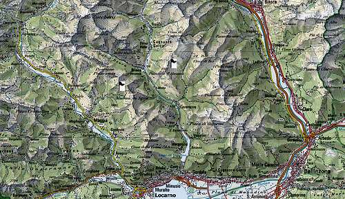
Area Overview Map
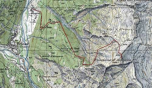
Route details: marked in red
How to get there

during the ascent

Pyramid like summit of P. d'Alnasca

Alnasca
The A2 highway crosses Switzerland from north to south. On this highway take exit 'Locarno'
Follow the Locarno signs for several miles on this secondary road.
After a few miles there will be signs saying: Val Verzasca. This will lead you to Val Verzasca.
In the Verzasca valley is only one major road. You follow this road and you will first pass the village of Vogorno, than you will pass Lavertezzo and the 3rd major village is Brione. Here you can park your car and walk towards the north in less than a kilometer to the village of Alnasca. In the center of this small village is a crossing of 4 roads. The one that heads east is the starting point for the route.
Camping

Poncione d'Alnasca

Alnasca from Pizzo Vogorno
Camping Al Censo, Claro.
A beautiful campsite on less than half an hour drive from Verzasca.
For more info:
camping Al Censo
The nearest Hotel is in Vogorno:
Hotel Pizzo Vogorno
Weather & Links
Click for WeatherVal Verzasca Tourist office
6598 Tenero
Tel +41 (0)91 745 16 61
Info@tenero-tourism.ch
www.tenero-tourism.ch
Official Ticino Site
In memory of...
This page was made with the great help of SP member Cyrill Rüegger , who tragically died in an accident on Piz Palü on June 13th, 2009.Rest in peace Cyrill, you will be missed.
---------------------------------------------------------------------------------------------------------------------------------------------------------------------
Mathias Zehring - May 31, 2009 4:19 am - Voted 10/10
techno climbing routethrough the left part of the overall impressive south face of Poncione d'Alnasca leads a artificial climbing route in big wall Yosemite style: "Himmelsfinger", Lars Hofer and Urs Waldispühl, 2001, VI+, A3 description in german topo