|
|
Route |
|---|---|
|
|
38.98525°N / 116.84043°W |
|
|
Download GPX » View Route on Map |
|
|
Hiking |
|
|
Spring, Summer, Fall |
|
|
Half a day |
|
|
Overview
On the main page, Dean mentioned other possible routes for this peak. Since his route didn't sound real good (or real bad either), I picked a different route. Without doing his, I can't really say which is better. The roundtrip stats for each are about the same. I'm gonna guess his had more sagebrush to push through, while mine had a couple more short but tedious treewhacks. However, mine starts near Northumberland Pass Rd, the best road that crosses the Toquima Range. This would be convenient for those coming from the Toiyabe Range over to the east side of Toquima or to Table Mtn in the Monitor Range.
Getting There
Start on Monitor Valley Rd (NV-82) at 38.8812,-116.7721. Northumberland Pass is WNW on NF-023; it was signed (from S) for something Northumberland (Pass, Road, Mine, etc.) At 7.2mi, turn right, away from the mine, and signed as so. The road gets curvier, but still good for 2WD. As the road starts downhill (at 10.9mi or 38.9679,-116.8476), turn sharply right (NE) on a fair 2-track road. Reset odometer. In 300ft I forked right for the less steep route. (I returned down the other, and it wasn't that steep but did have a moderate rut.) At 0.4mi saddle, stay straight as the road crosses to the other side. The road never gets very rough, and most SUVs should handle it; you may have to move a few loose rocks my Wrangler went over, and expect a few scratches from trees. 4WD and off-road tires recommended for a steep section at 1.6mi and for some sharp rocks. I don't remember any fixed obstacles requiring high clearance. But keep in mind, this is a shelf road, with few places to turn around or move off the road. AT 1.8 mile, after a downhill to a small saddle, the main road turns right and downhill. This is where I parked. An unsigned road continues uphill, but is very steep and rutted, and probably best left to ATVs.
If coming from the west side, Northumberland Rd starts from NV-376 at 39.1250,-117.1030. The last Google Earth photo from 2014 appears to be just as good as the east side; however, I did not drive that side. If coming up NV-376 from the south, there is also a short-cut to the canyon starting at 38.8933,-117.1938. The directions are more complicated, but they are depicted on my Benchmark Road Atlas.
Route Description
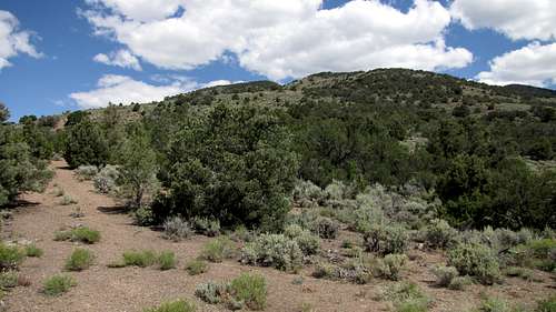
Start up the ATV road; it ends in 0.3mi. Stay in the clear on the left side of the crest as you pass Spot 9277. Next is where my route needs improving. I crossed over to the right side and tried to sidehill around Contour 9600. It started well but ended in a steep treewhack. Tried a higher sidehill coming down, and it was only a little better. It now looks best to stay on the left (W) side and stay in open gaps as high up as you can. You'll still have to pick/push your way through 200ft of forest to go over the bald top. This is the worst part of the route.
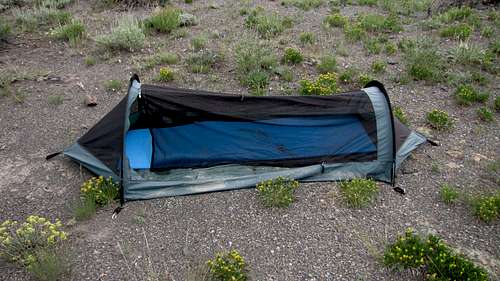
Over the top, turn NE and down the ridge to the 9400msl col. (BTW, there is a one-person backpacking tent abandoned here. It was left with its rain fly off and the opening unzipped. Appeared functional. Left behind in a sudden thunderstorm?) You have two choices after this col.
First, I started up the next ridge on open terrain to about 9640msl, then followed a good sheep trail level on the left (w) side. Then it turned NNW and descended about 80ft. I lost it briefly in some deep sagebrush, but quickly regained it above and beyond some trees. This one climbs 200ft before descending 80ft. I then followed it to the 9560msl col, where it joins Dean's route coming from Mill Canyon.
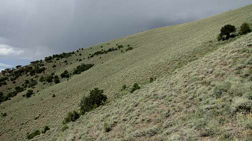
Second, on the way down, from where the trail is lost, I angled slightly downhill through sagebrush, still going forward but losing 160ft, until I picked up a good trail that rises gradually to the 9400msl col. The photo above is looking back from where I joined the lower trail on descent. I think each way was best for the direction I was traveling.
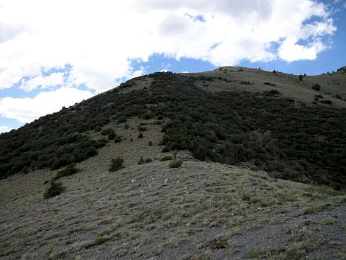
Going up the next steep ridge, again try to pick through gaps on the left (W) side of the crest. You'll once again have to pick, push or tunnel beneath some trees. The rest is straightforward.
Round trip: 5.0 miles, total gain 2325 ft
From Northumberland Pass Rd: add 3.6 miles, and combined 683 ft gain
Essential Gear
Add Essential Gear text here.
External Links
Add External Links text here.