

Comments
No comments posted yet.
|
|
Trip Report |
|---|---|
|
|
37.15520°N / 118.6816°W |
|
|
Jul 31, 1994 |
|
|
Hiking, Mountaineering, Trad Climbing, Toprope |
|
|
Summer |
Mount Spencer
...by way of an Echo Col->Ionian Basin->Lamarck Col loop hike, August, 1994.
NOTE: This report was written shortly after the trip in 1994. I have since edited it for continuity and to correct geographical mistakes.
Saturday:
Gary and I arrived in Bishop after a typical drive up US-395, but this family in a van at our rest stop were having a night-long fiesta at our expense. We didn't get much sleep. We went directly to the ranger station on Main Street and read the paper sign taped to the door informing us to go to the Bishop Creek Entrance Station and wait in line. No surprise, but we're last in line. After learning that the trail we wanted was full, we lounged for a couple hours and got a defaulted reserve-a-permit (whew!). Back to town for breakfast!
In town, we met Dean and his buddy Mike. Dean is an expert fly fisherman, and Mike - for this trip, at least - was his apprentice. We then went to a pancake house on Main Street and quaffed a great breakfast before doing some planning. Dean and Mike were headed in on the Bishop Pass trail, and Gary and I had planned to go up the Sabrina Basin trail towards Echo Col. We all agreed to meet at Chasm Lake in Ionian Basin sometime in the middle of the week.
We drove back up the mountain and hung out at South Lake for the day, fishing with Dean and Mike. This extra day was supposed to be an aclimatization day, so we just relaxed. Near sunset, Gary and I headed to Sabrina Lake and hiked a mile around the lake to a nice, small camp near the trail. At about 9:30 PM a family stopped on their way up the trail. We conversed a little while about where there is water, what kind of campsites are ahead, etc. They left us in peace, and we were entertained by their flashlight-lit progress up the trail at the back of the lake. Soon we turned in, happy to be at least a mile from the blacktop.
Sunday:
We awoke to the sound of small motorboats on the lake. It was still early, around 6:00 AM. We packed, munched a little, and hit the trail. The weather looked great, and the temparature was moderate.
The trail into Sabrina Basin is very circuitous, winding around intrusions of stronger granite that withstood the glaciers. In between these domes and dikes, a nearly continuous lawn of very green grass and vibrant wild flowers covered everything that was not rock. After we hastily dodged the "public park" atmosphere of Blue Lake, we wandered past Dingleberry Lake and Topsy Turvy Lake, and ended up at Moonlight Lake, where we set up camp for the night.
Here, Gary caught seven rainbow trout and made me clean them. Fair enough. He then cooked them up and we just as quickly devoured them all. We turned in a little early, anticipating a death scramble in the morning.
Monday:
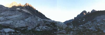
We woke early, packed and ate. Then we wandered aimlessly, having passed the terminus of the trail. After a stroll across the lawn (I can't help but call it that) we started to scramble over talus up to Echo Lake. We were now above treeeline, and wouldn't see trees again for a week.
Echo Lake is really strange. It appears to have been scooped out of the raw granite with an ice cream scoop. There are sheer cliffs on all sides save the north, where the outlet stream plunges through the talus. We sat in the sun on the only suitable flat spot in the area, a small greensward near the outlet of the lake. From here we eyeballed our route up the ramps and ledges above the east shore.
A ramp of loose talus lead from the outlet of the lake up and above the cliffs on the east side of the lake. Near the top of these cliffs, we traversed south on ledges and talus and into the cirque above. After an uneventful hike across the snowfield, we began climbing up steps and ledges at the back of the cirque.
The rock soon turned rotten and very loose. This wasn't much fun. At this point, Gary invented the dry-land drag-bag. He removed 20 pounds of food from his pack and put it inside a stuff sack. To this he tied a 25-foot length of supertape. The method used was rather unlike a normal drag-bag, however. One would throw the bag up to the next level (if at all possible), then climb above the bag, then haul the bag up...throw...climb...haul... Constructing a drag-bag of my own, I proceded to put my pack on a diet as well.
Soon the climbing became rather steep, so we removed our packs altogether and began hauling them. Actually, Gary was doing the hauling and I was doing all the pushing.
On a large ledge just below the crest of the ridge, we decided that it might be a good idea to rope up. With an ineffective belay anchor (slings tied to a few questionable flakes) and a little courage, Gary set off in search of a passage across the ridge. The rocks began to rain down upon my ledge. A very sharp rock fell right next to the stacked rope and stopped in the sand. Gary worked his way left over a jumble of hanging debris, and found a hole leading under a chockstone. I watched him struggle through this hole, then heard him cursing in dispair as he discovered his error.
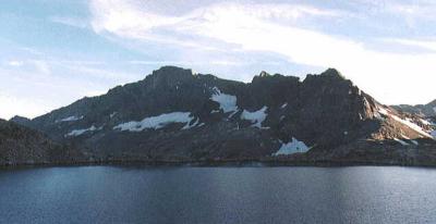
He had pulled up atop a flat, square-cut tooth in the ridge, with a 200-foot rappel down the south side. This was supposed to be easy! He miraculously reversed his course and we decided to go to the right on a large sandy ledge. We passed around a large corner, very high on the wall now, and worked right to low-angle ledges. We unroped at a sandy patch below a narrow notch in black rock (funny, the guidebook said something about 'black rock'). From here, it was an easy scramble over the notch and onto the talus on the south side. The view from the top of this notch was wierd, yet spectacular. One side is California, and the other is Mars. After an easy climb down the south side, we were in Kings Canyon National Park and the Kings River drainage.
We trudged down the talus to a 'C' shaped lake (Lk. 11,428), where we camped for the night. Here, the view was very expansive. The panorama to the west included Mt. McDuffie, Black Giant, Mt. Solomons, and Mt. Goddard in the distance. The camp site we chose was a good one, tucked behind a double-dome, in the sandy margin of a 30-foot by 50-foot meadow.
Tuesday:
We awoke to a crystal clear morning and set out early. We hiked around the north side of the lake and started down some easy slabs to the southwest. A few minutes later I heard a loud shout behind me. I turned in time to see Gary cartwheeling down the slabs, his 70 pound pack carrying him to his doom. I ran back in his general direction, hoping and doubting that I could stop him, but after a few rotations, he landed on his side (whump!) on a sandy terrace. After some grunting and griping about slabs and gravel, we continued down the slabs to the Kings River.
The Kings River is a broad, shallow stream this high in the drainage. It was very strange to walk over the river here. The stones were mostly about the size of a wedge of cheese, and roughly that shape. The water had washed away the gravel beneath, leaving most of the stones with a flat side turned toward the sky. This made for a nice cobblestone effect. The water here was only a few inches deep, but the stream was about 50 feet across.
We stopped for a breather next to the John Muir Trail. Gary wanted to keep going, so I said I'd see him later, and I proceeded to goop up with sun block and bug juice. After a short sit in the sun, I continued up the trail behind Gary.
The trail now followed the stream up a zigzagging canyon. This was a very interresting canyon composed of brown, black, red, orange, white, and gray metamorphic rock. Everything was crumbling, and the biggest blocks (most the size of refrigerators) were still hanging above the trail on the walls of the canyon.
After a mile or so, a dramatic change occurred.
I walked out into a basin above the head of the canyon, and the geology was starkly different. Here, the rock was white granite - sparkling white granite! A few steps into the meadow and I could see Gary sunning atop a stage of granite next to Helen Lake.
This was a rather impressive valley. Mt. Solomons dominated the view, standing much like a Cascades volcano above Helen Lake. The meadow swept south up to Black Giant Pass and was studded with strangely symmetrical domes and boulders. There was a haze of color over the grass, mostly yellow with occasional red and blue. I have never seen such a clean wilderness!
After we snacked a little, we walked south through the valley toward Black Giant Pass. After a false summit and a large, shallow lake, we scrambled up the final talus slope to the summit of the pass. Another change in geology took place here. From the white granite of Helen Lake, we passed through brown and black granite on the north side of the pass. Suddenly the rock reverted to the crumbly metamorphic rock of which this region is largely composed. Everything south of here was pretty much the same, with rare intrusions of white granite.
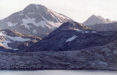
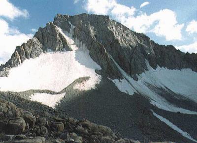
Mount Solomons (left) and a waterfall in Ionian Basin |
Charybdis at left, The Three Sirens and Scylla at right |
The "trail" followed the watercourse down from Black Giant Pass, winding down very loose scree, and then making big steps down to Ionian Basin. These steps reminded me of a fountain with many bowls, with water spilling first from the top bowl into the second, then finding its way out of the second into the third, and so on.
We stopped for a lunch break at the brim of one of these fountain bowls, facing an unnamed peak to the west of Black Giant. At the foot of this face of the peak, there was a beautiful lake. Overhanging the edge of this lake was a snow field, split by a crevase that looked like an upside-down grin.
After lunch, we headed down to Ionian Basin. On the floor of the basin, the rock was primarily white granite, and very shattered. This place was really strange because it looked like someone purposely hauled all of this white granite here and arranged it between the dark, crumbling, scary peaks.
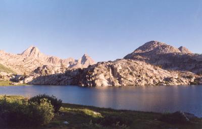
After some very circuitous walking and scrambling, we reached Chasm Lake, our camp for the night. Chasm Lake is appropriately named. It is rather oblong, running north-south in a canyon that lies between Charibdis on the east and Scylla and The Three Sirens on the west. Immediately surrounding the lake, though, are a collection of domes, sheer walls, and buttresses. On the northern side of the lake the domes are rather large, and are composed of white granite. The most impressive of these lies on the west side of the lake. It is about a mile and a half long, and is rather stretched north-south in graceful arcs. The pattern is vaguely similar to a bouning river, or the backs of many whales. On the south side of the lake, there are several dark domes that look just like huge scoops of Rocky Road ice cream.
After we unpacked and flopped on the ground, I noticed that I didn't have my watch on my wrist anymore. This is probably because it is still on my pack, where I left it at lunch. I looked all over, around, and through my pack, but no luck. It must have fallen off, either at the lunch spot, or somewhere between here and there. It was a really nice watch, but, goddammit, I'm tired! Gary tries to talk me into going back and looking for it, but I REALLY AM TIRED!!
We ate dinner and sacked in for the night.
Wednesday:
The next morning, we were really moving slow. We had planned to climb Charibdis today, but all we could do is sit in camp and stare up at the scary chutes and ribs of loosely piled rock. We called it a rest day and started searching around for something else to do.
Gary went out to take a dump and found a series of very interresting crags just north of the lake, so we packed the climbing gear and headed off for some T'R'ing. This proved to be fairly exciting. The first thing we had to do was clear all the loose rock from above our selected crag. We spent the next half hour trundling. What great fun! What excitement! Crash! Smash! CRACK!! "Yippie!!!" We could smell the ozone in the air!
We selected a fairly interresting corner to climb, starting on a square shelf ten feet above the ground. The climbing was about 5.5 on really neat rock. The first few moves were up a layback crack in the corner. After that, a switch to a flake on the right face of the corner allowed one to stand up and reach the next segment of the crack. This led to the top and the rounded exit. Gary even tried exiting over a large canteloupe-wedge of rock that hung over the right side of the easy exit. We bored ourselves doing laps, then headed back to camp for lunch.
While we were sitting in camp and watching the world float by, we spied two hikers scrambling down the slope toward our camp. They walked right up to us, stood in our sun, and one of them asked "Did either of you two loose a watch?"
Though I was grateful for having my watch returned, these were not the two hikers we'd expected. We were supposed to meet Dean and his friend Mike here on this day. As we learned after the trip, Mike had accute mountain sickness from hiking over Bishop Pass too quickly, and they both headed down LeConte Canyon to camp in Quail Meadow. While they were camped there, Dean had to fight off bears while Mike cooked the meals. Makes me glad we only saw mosquitoes and marmots.
Thursday:
We awoke at Chasm Lake early and got a good start. As we headed up to the lake below Wanda Pass and Solomons Pass, I felt like I was hiking somewhere in England. I've never been there, but I've seen lots of it in TV and movies.
We caught up to the hikers at the lake, and decided to keep west of them. After we rounded the lake, we spotted two more parties scrambling toward Wanda Pass. Rush hour? I (not We) made an error in navigation, and we ended up too close to the wrong saddle. After a traverse across steep talus - following ducks all the way - we made it to the correct pass. The top of this pass, made of white granite, looked like a cosmically laid brick wall, hundreds of feet thick, with a shattered crest. The loose blocks were surprisingly symmetric, and scattered among seemingly measured alcoves.
We made our way down to Wanda Lake and I (not We) decided to walk the wrong way around the lake. No big deal. It was a pleasant stroll that only cost about half an hour. Back on the John Muir Trail, we reverted to auto-hike and sailed down the Evolution Basin.
On our way down the Basin, we encountered a CCC camp and a loud gasoline compressor. We wondered if they might also have a generator and a fridge full of cold beer. The CCC keeps this trail immaculate, from raising it above the level of meadows on granite "planks", to raking scree from the trail in rockfall zones. They even placed huge ottoman-shaped boulders across Evolution Creek at intervals perfect for stepping right across.
We soon reached Evolution Lake, and found a piss-poor campsite. After some lounging around, we searched for a better campsite. We determined that tomorrow would be a rest/climbing day. Then we wandered around and took pictures before eating and sleeping.
Friday:
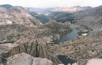
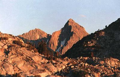
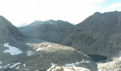
The view from the summit, down Evolution Valley |
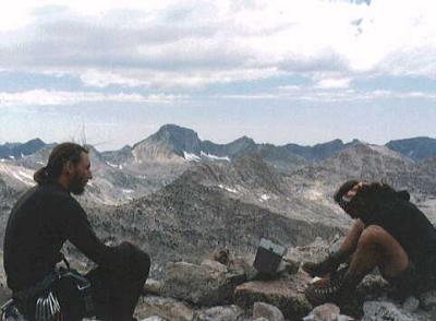
Gary (right) and I (left) on the summit of Mt. Spencer |
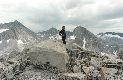
The author on the summit of Mt. Spencer |
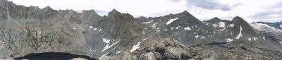
Haeckel-Huxley Panorama |
Today we lounged around camp until 9:00am. It was a partly cloudy day, and it looked like it might rain. We packed some gear and munchies and set off for Mt. Spencer, a small peak between Mt. Darwin and Mt. Huxley.
We hiked the John Muir Trail until we were at the ford over the inlet of Evolution Lake. Here we kept on the east side of the river, following the base of the mountain. After crossing a small stream, we walked and scrambled over granite steps and stages up to the base of the dome-like west flank of Mt. Spencer. We then scrambled up the class 3 flakes and slabs of the dome. This leg of the climb was really enjoyable because the rock was so clean and solid, and the route wandered between whitebark pines most of the way. The top of the dome is actually a bench that wraps around the south side of the mountain, with a few small tarns sprinkled about.
Keeping to the north edge of this bench, we scrambled over boulders and steps. We aimed for the northern margin of the west face, heading for a crumbling buttress on the northwest corner of the summit mass. After scrambling up and right, through many loose gullies, we reached a large, sandy ledge below a steep white face of rock split by several cracks, two of which looked climbable. I jammed in a couple hexes for a belay and Gary headed up the crack on the right.
About 40 feet up, he reached a small bush that was growing in an intersection of cracks. The bush gave him a bit of a problem, but shortly he was on his way again. About 50 feet later, he disappeared over the top of the face, then shouted some obscenities. I asked what the hell was going on, and he replied that he was faced with delicately scrambling over a six foot tall arrowhead-shaped flake that was balanced in the back of the small alcove he was in. He thinks he can do it, but the damned thing keeps moving when he touches it. Then he shut up. Now I'm scared.
"Off belay!" he shouted a few minutes later.
Seconding was really easy, at first. Then I got to the bush. The crack was choked for three feet with waxy veggies! I liebacked with my feet slipping off stems and leaves. After this obstacle, the rest of the crack was relatively easy. The crux, however, was 30 feet above the bush at a point where two flakes formed a "V" right at their intersection with the crack. The mantel to gain the top of these flakes was perhaps a 5.6 move. I topped out above the wall, only to be confronted by the arrowhead! This flake really horrified me! After some thinking and false starts, I managed to climb over the flake without even touching it. I stemmed the alcove and stepped right up into the talus above. Gary was belaying from a crown of talus, a rather nice nook out of the wind. After we unroped and got reorganized, we scrambled the remaining few hundred feet to the summit. The view - like the view from any Sierra summit - was excellent!
After munching lunch and taking a bunch of pictures, we signed the summit register and looked at the history here. Most of the comments were pretty mundane, and some were overblown. Many of the recent signatures were those of the CCC members that were working on the John Muir Trail in this area. There were also a few semi-famous names, but no "Norman Clyde" or "John Muir".
We scrambled down the east ridge to a place where we could get off the ridge to the south. The view as we traversed this ridge was spectacular! Directly east of us, the ridge curved north and joined the Mt. Darwin massiff. There were lakes on either side of the ridge. On the north side of the ridge, though, was a very deep, very blue lake that reflected the orange and white granite of Mt. Darwin. On the south side were a scattering of small lakes and tarns between a carpet of vibrant lawn green. Across this beautiful cirque, Mt. Huxley rose quite sharply. On the north face of Mt. Huxley, there are a variety of sharp aretes and colouirs sculpted from very pure white granite.
There were many ways down the south face of Mt. Spencer, and almost all of them had footprints. Coming down this part of the mountain was like descending a spiral staircase, though not as uniform. The rock was extremely broken, and the chutes were curved and bent back upon themselves, letting one out underneath the top of the chute. This was somewhat creepy; it made me worry a lot about rockfall.
We circled south back to the John Muir Trail, then back to camp. We ate dinner, then went out to take pictures. The sunset was beautiful, but only for a few minutes. The alpenglow on Mt. Spencer and Mt. Huxley was marvelous. Right at the head of the Evolution Valley (not to be confused with the Evolution Basin), the San Joaquin River plunged down glacial slabs for several hundred feet. It looked just like a giant waterslide! We walked out on the east rim of the valley for a little and looked back. To the west, and about 30 degrees around the curve of the valley, there was an identical canyon with an identical waterslide.
Perhaps the most impressive sight at Evolution Lake is the southwestern aspect of Mt. Darwin. This giant face rises high above the lake in huge talus fans and gullies, and is punctuated by leaning buttresses of rock at it's base. It is terribly crumbly, but looks like it might have been a huge building at one time. This is because of it's relatively square shape.
We headed back to camp and talked while eating desert, then we turned in for the night.
ROUTE DESCRIPTION: Arrowhead, 5.6, Mt. Spencer
Saturday:
We got an early start today. It was slightly colder this morning. There was no sun, and I thought today it would surely rain. We stuck to the John Muir Trail until it started to traverse the east rim of the Evolution Valley, then we headed east and up around the base of Mt. Mendel. Mt. Mendel is Mt. Darwin's neighbor, and nearly as big. We were simply rounding the toe of the west ridge of Mt. Mendel's subsidary peak, Peak 13,385.
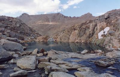
The next two hours we spent winding our way between small dikes and domes of granite strewn across the floor of a hanging valley. Bending to the south, we entered Darwin Canyon. The atmosphere here was one of newness and violent change. There were few trees, but there was grass everywhere. The rock here is a pinkish granite that is fractured somewhat randomly. On the floor of the canyon is a string of lakes that are a stunning glacial green. The lakes are spaced so closely that each seems to be separated from the other by only a small dike of granite.
At the head of the canyon, we passed a small hollow where a few fishermen were camped. We continued to the last lake at the head of the canyon. From here we could see the Darwin Glacier on the north face of Mt. Darwin. It was piping freezing cold air right down the canyon. We waited for a packing human to vacate a nice campsite, then we took over. After a little rest and some food, we decided to go climb something and take pictures.
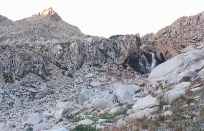
Near camp was a stream that emptied the tarns below the Darwin Glacier. It flowed over a heavily fractured slope of granite, entering cracks and disappearing periodically. We followed this stream up the slope, then went to the left and followed a rounded ridge up to the base of a large, broken blob of rock. The rock was of varied colors, in contrast to the mostly pink granite in the canyon. After climbing over many sloping ledges and large blocks (that were sitting on the sloping ledges), the climbing began to get steep, and the many blocks and ledges became rather scary boulder problems perched above lots of nothing.
Just below the top the terrain eased a little, then suddenly became flat. We had topped out on a rounded shoulder that jutted out from the northeast ridge of Mt. Darwin, just below Point 12,733. We walked southeast over the broad, flat ridge. After a while, it was possible to exit south on ledges. We finally reached slabs at the base of the ridge and scrambled down a low-angle corner, then stepped off the slabs onto the sand and scree below. We walked around the north side of the point to a small tarn just above the cascade that led back to camp. Here I took some pictures, focusing on the extreme glacial green of the tarn. The colors here were magnificent. Greens, grays, pinks, whites, blacks, and various combinations of the above were present. Across the canyon, we could see emerald terraces of grass leading up through pink granite to Lamarck Col.
We scrambled down next to the cascade, then back to camp. Since tonight was the last night, we elected to eat as much food as we could for dinner. This dinner was mostly "add-two-cups-boil-stir-n-serve", but we ate a lot of chocolate pudding and strawberry jello, too. Afterwards, we got lazy and decided that neither of us was going to do KP, so we packed the dirty eatingware and sacked out.
Sunday:
It was cold when we awoke. The Darwin Glacier was piping more cold air, so we scarffed breakfast, packed, and split. The "trail" up to Lamarck Col was mostly big talus, with stretches of "kitty litter" sand between. It wasn't at all difficult to find the correct route. There were footprints everywhere! In fact, we were following two other parties up the Col.
At the top of the Col, there were two switchbacks on each side, and a sign right at the top informing us that we were leaving Kings Canyon National Park. This sign also set out the rules of the park with respect to dogs and firearms.
Here we sat in the sun for a while, enjoying the last of the clean air. Sitting next to us was a large marmot. The marmots in this section of the Sierras are very different from those found further south. They are mostly tan, with a "vest" and "mask" of black. This one didn't seem to mind us sitting here, but when another party came up from the south, he split for a while. When the other party left, he came back to watch us (or hang out with us?).
As the other party made its way down the snowfield, we watched...and winced. The last guy down walked over the last few blocks towards his group, who were already lounging around the small tarn below the snowfield. As he got close to the edge of the talus, he slipped, plunging his right leg deep between the blocks. This forced him to do the splits, a scary prospect even without a heavy pack on one's back.
Then we saddled up for the last time and headded down. We avoided the snowfield entirely, however, because the talus to the right of the snow was much easier. At the bottom, we picked out the sandy track that led down the canyon. Soon we were walking over and around small blocks strewn across a sandy plain. This part was rather annoying. Then the "trail" consolidated and sped off down the canyon. Here Gary was far ahead of me. I didn't even try to keep up. I figured we were ending up at the same place, so why kill myself. After a while, I lost him completely. I passed the old codgers and continued down the trail.
The trail was fairly striaghtforward, until I reached the Lamarck Lakes Trail leading to North Lake. This trail, much like the Sabrina Basin Trail, winds through many domes and dikes of granite, making travel circuitous at best. Throughout this section, I thought I was following Gary's boot prints. I followed them right down to North Lake, where I filled up with water. No Gary! I figured he must have walked down the road to the hiker parking. Nope! I walked most of the way down the North Lake road, but I was picked up by a nice couple in their pickup truck about one mile from the Sabrina Lake road.
I sure was glad to be back at the car already, but where was Gary? I got packed, put on my tennies, then began to drive around. I drove up to the North Lake trailhead, then back to the hiker parking, then back to the trailhead, then back to the hiker parking. I parked here and began to read anything in my car just to stave off boredom. After a couple of hours of reading, I was getting really hungry. I started the car and drove out of the hiker parking only to see Gary marching out of the parking lot too. He said he had walked into the lot, but didn't see me. He hopped in, and we headded to Bishop for a much-needed lunch.
On the way back to town, Gary told me why he had become lost, and subsequently late. He had taken a left turn somewhere above Upper Lamarck Lake, just before treeline. This was a big mistake. He scrambled down several hundred feet of loose rock, realizing only too late that he was off route. After much fearful scrambling, he reached a cliff over a glacier above Upper Lamarck Lake. He sat for a while and contemplated his imminent death, then decided to do whatever he could. Fortunately, he was the one carrying the rope!
He slung the rope around a loose horn of rock, then rappelled 60 feet to the glacier. Then, after scrambling from the moat, he glissaded down the glacier to the lake, narrowly escaping a cold plunge at the bottom. After crawling through huge talus around the eastern margin of the lake, the rest of his hike was uneventful.
We ate a great lunch in Bishop, followed by copious amounts of 31 Flavors ice cream. Then, after window shopping a bit, we drove out of town and headded back to Hell (Los Angeles).
FIN!