
-
 4999 Hits
-
 84.82% Score
-
 19 Votes
|
|
Mountain/Rock |
|---|---|
|
|
44.03009°N / 10.69887°E |
|
|
Hiking, Scrambling |
|
|
Spring, Summer, Fall |
|
|
3776 ft / 1151 m |
|
|
Overview
 The south face f Monte Memoriante as seen from Penna di Luchio The south face f Monte Memoriante as seen from Penna di Luchio |
In the Svizzera Pesciatana, the beautiful backcountry of Pescia in Toscana (Tuscany) there are quite a number of limestone mountains of all shapes, sizes and difficulties, which tower above the profound valleys of the area with theiir picturesque villages, which somehow appear to be clued to the steep slopes of the mountains. In particular there is a ridge, one of the highest ones of the area, where there are hiking and easy climbing objectives, very popular among the locals but also advertised by the better guidebooks for the area. The ridge consists of four mountains: Monte Granaio (1043m), Monte Lischeta (1077m), Penna di Lucchio (1176m) and Monte Memoriante (1151m). The latter two, apart from being the highest ones, are also the most interesting destinations.
Penna di Lucchio attracts most attention, mainly due to the fact that it can be reached by two serious marked routes, one a steep traverse along its north ridge, the other a seriously exposed but still moderate climb along the southern one. Its direct neighbour, Monte Memoriante, is far less popular, though iit also attracts attention, mainly when seen from the top of the Penna. However, if the routes to Penna di Lucchio appear to be serious, the ones to Monte Memoriante really are and most would-be climbers are deterred by steepness, exposure and the seemingly low quality of the rock. As on the Penna, there are two routes, both climbing the soouth face of the mountain. The direct one starts with a rotten chimney to climb the south ridge of the mountain, while the second one traverses the south face on steep and very exposed ledges which lead to a plateau-like dell in the west of the mountain.
 |  |  |  |
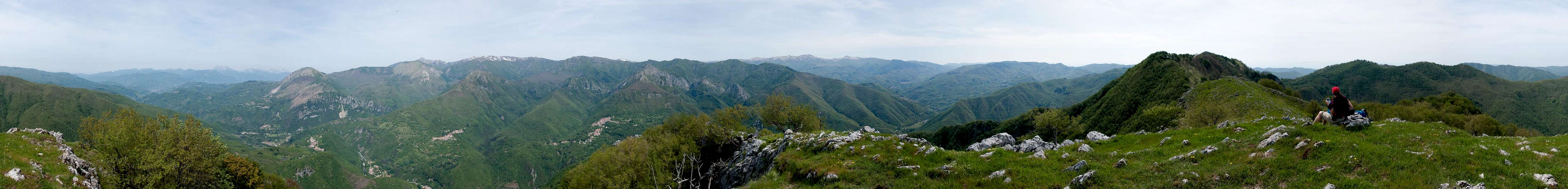
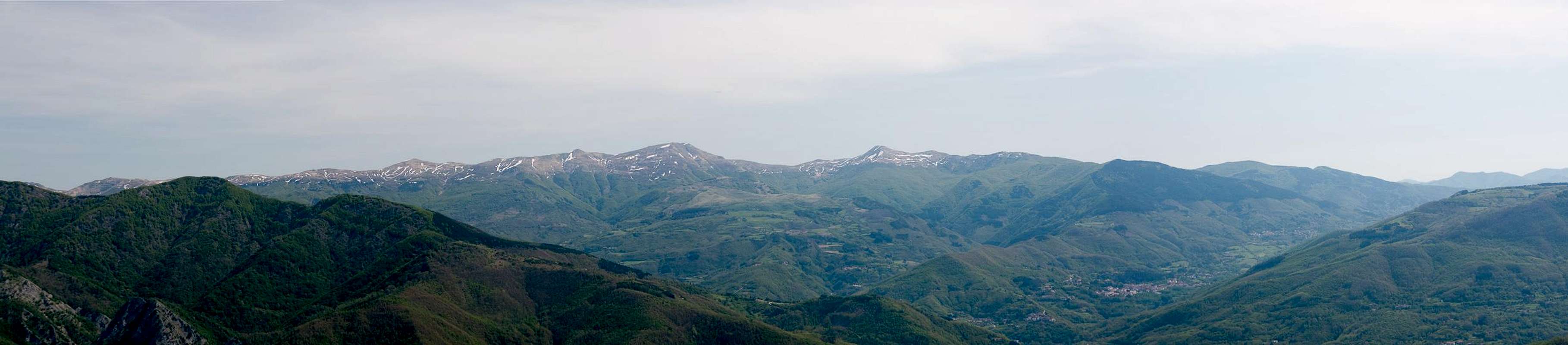
The summit of Monte Memmoriante is something of an anticlimax. While the east face drops off vertically towards Lucchio, the top of the mountain is a wide plateau from which ridges lead in all directions. On the other hand, the plateau reveals the karst-like nature of the mountain and - as usual for karst plateaus - offers multiple nooks and crevices for a very interesting flora. The most impressive of the ridges is the northern one,, which steeply drops for 700m into the Lima River Valley. As for summit views - given the fact that Monte Memoriante is not exactly tall, it offers suprisingy far reaching views towards the Alpi Apuane in the north-west and the main ridge of the Appennino to the north and east.
360° Summit Panorama
  |
Getting There
 |
There are two possible trailheads, one at Lucchio in the north and one at Pontito in the south of the mountain. Both villages are connected by a potholed road, which is no fun to drive without a high clearance vehicle. From the two international airports of Pisa and Firenze (Florence)the itineraries are as follows:
- From Firenze
- Lucchio trailhead
- Take motorway A11 direction Pisa
- At the exit Pistoia switch to SS66 to San Marcello Pistoiese
- At La Lima switch to SS12 direction Bagni di Lucca
- After 5km follow the sign to Lucchio
- Pass the village and park your car at the entrance to the hamlet of Zato
- Pontito trailhead
- Take motorway A11 direction Pisa
- Take the exit Monsummano / Monte Catini
- Follow SS435 to Pescia
- Take SP3 to Pietrabuona
- Switch to SP34 to Lanciole il Poggetto
- Follow the signs to Pontito and there follow the signs to Croce al Veglia.
- After a few km you reach the chapel Madonna delle Grazie, where you can start the ascent
- Lucchio trailhead
- From Pisa
- Lucchio trailhead
- Take motorway A11 direction Firenze
- At the exit Lucca switch to SS12, direction Abbetone
- Drive through Bagni di Lucca and after 17km follow the (hidden) sign to Lucchio
- Pass the village and park your car at the entrance to the hamlet of Zato
- Pontito trailhead
- Take motorway A11 direction Firenze
- Take the exit Chiesina Uzzanese
- Follow SP13 to Pescia
- Take SP3 to Pietrabuona
- Switch to SP34 to Lanciole il Poggetto
- Follow the signs to Pontito and there follow the signs to Croce al Veglia.
- After a few km you reach the chapel Madonna delle Grazie, where you can start the ascent
- Lucchio trailhead
Red Tape
 Iphiclides podalirius
There is no red tape here. However, can find orchids on the slopes and ridges of the mountain. These flowers are protected all over Europe so leave them in their place. Also, the east face of Monte Memoriante is nesting ground for peregrine falcons. Make sure not to disturb these rare birds, especially in the nesting season in spring.
Part of the access roads run through private property so stay on track. Also, there is a gas pipeline, which crosses the ascent path and which follows one of the ridgelines in the area. Open fire is discouraged ;-)
Accommodation
Either stay in hotels in the big towns (Pisa, Lucca, Firenze) or make use of agriturismo, the offer of rooms and apartments by local farmers. You'll find signs along the roads and the bigger establishments can be booked by internet. The quality of the lodging differs greatly but prices are reasonable.The closest towns with hotels are Bagni di Lucca in the west and San Marcello Pistoiese in the north-east.
Weather Conditions
Maps & Books
Maps
I have not been able to find detailed maps of this area so the following one is a road map, scaled 1:150000
- Tuscanny - Florence
Freytag & Berndt
1:150000
ISBN: 978-3-7079-0281-5
Maps Online
Books
- Tuscany North / Toskana Nord
Wolfgang Heitzmann / Renate Gabriel (translation: Gill Round)
Rother Verlag
ISBN: 978-3-7633-4812-1 (English)
ISBN: 978-3-7633-4115-3 (German)