
|
|
Mountain/Rock |
|---|---|
|
|
44.32706°N / 120.37332°W |
|
|
Crook (County High Point) |
|
|
Hiking, Skiing |
|
|
Spring, Summer, Fall, Winter |
|
|
6926 ft / 2111 m |
|
|
Crook County Highpoint
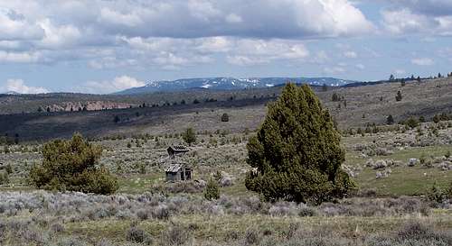
The county highpoint for Crook County, Lookout Mountain is also the second highest point in the Ochoco Mountains of central Oregon. From the summit on a clear day you can see most of the Oregon Cascades in the West to the Strawberry Mountains in the east and nearly all of the Ochocos. Lookout Mountain lies within a protected wilderness area and has not been subject to logging or other industrial use other than pioneer mining. The Independent Mine site near the trailhead features a caved in mine shaft with a stream running from it down an old mining cart railway.
The Lookout Mountain summit is the location of an old lookout, at one time fenced in with a rock wall which still stands today. This summit lies in the middle of a long sagebrush meadow that runs the length of Lookout Mountain near a winter sports shelter with fireplace for cross country skiers.
Seen from Izee Highway
With nice even grade trails, Lookout Mountain is a popular destination for mountain bike enthusiasts and horseback riders. Be prepared to find horse scat on the trails, and to potentially see cattle on the mountain. In winter months, Lookout Mountain is an ideal cross-country skiing and snowshoe destination.
Lookout Mountain is #40 on the list of Oregon peaks with 2000 feet or more of prominence.
Getting There
Travel roughly 16 miles east of Prineville on US highway 26 to Forest Service Road 23 on the south side of the highway. Follow FS road 23 for eight miles and just after the Big Summit Work Center take a right on Canyon Creek Road (FS road 42) which you will follow 6.5 miles to the saddle between Lookout Mountain and Round Mountain (all roads are paved to this point). Take a right and follow the rough dirt road less than one mile to roads end. Here pick up one of the three trails to the summit. Each trail runs less than 4 miles one way and has a little more than 1000 feet of elevation gain.
There is also a longer 7 mile trail on the south side of FS road 23 near the Big Summit Work Center. This trail is immediately before the right hand turnoff onto Canyon Creek. This longer route has nearly 3000 feet of elevation gain and passes near the summit of Duncan Butte at 5400 feet.
Red Tape
Beware of Mountain Lions. As of summer 2006 there is a warning posted at the lower trailhead warning hikers not to travel alone on Lookout Mountain. 
Late in the summer fire restrictions may be in effect, check with the Ochoco National Forest District for up to date information.
For fire danger and general condtions the Ochoco National Forest website is HERE
Camping
The Summit Meadow
Camping is available at Ochoco Campground near the Big Summit Work Center at the intersection of Canyon Creek Road and Ochoco Creek Road. Walton Lake at 5200 feet is a nice cool location for camping just a few miles past the Big Summit Work Center on FS road 22.
The winter shelter just beneath the summit alongside trail 808 if unoccupied also offers camping potential.