
-
 32428 Hits
-
 86.37% Score
-
 22 Votes
|
|
Mountain/Rock |
|---|---|
|
|
45.92802°N / 7.00176°E |
|
|
Haute Savoie |
|
|
Mountaineering, Ice Climbing, Mixed |
|
|
12650 ft / 3856 m |
|
|
Overview
Les Courtes 3856 m
It's named Les Courtes a mountain located in the French side of the Mont Blanc massif that feature a prominent and high North face which is a great action ground for ambitious alpinists in ice ascents and extreme skiers. The South side is somewhat friendlier and is more frequently climbed. The name Les Courtes means "short ones" and the reason is because they appear to be a bit shorter than the Droites, which are just situated to the right of Les Courtes when looking at the walls from the valley. Actually the name seems to be quite playful because the mountain is instead impressive, with high and majestic walls especially on the side of the Glacier d'Argentiere.
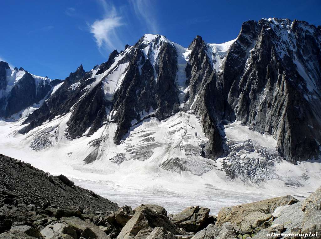
The mountain is located between the Talèfre Glacier basin and the Argentiere Glacier basin along the ridge that starts from the Aiguille de Triolet to the Aiguille Verte via Les Droites. Particularly demanding from a mountaineering point of view is the North wall facing the Argentiere glacier. The culminating summit has an altitude of 3856 m. In addition to the main summit, the mountain has several other summits: - Tour des Courtes - 3.816 m - West shoulder 3.841 m - Aiguille Chenavier - 3.799 m - Aiguille Croulante - 3.765 m - Aiguille Qui Remue - 3.724 m To approach the mountain, it is possible to use the Refuge du Couvercle (South side) or the Refuge d'Argentière (North side), depending on which side of Les Courtes you want to climb.
Getting There
The closest International Airport for this region is Geneva. The starting points for climbing are both the town of Chamonix and the village of Argentière.
Transport:
- Train: Railway station in the town. The Saint Gervais to Vallorcine line connects to the high-speed TGV line in Annecy (in peak season the TGV runs directly to Saint Gervais) +33-(0)450 53 1298; +33-(0)8 36 35 35 35
- Bus: Mont-Blanc Bus: Regular bus service covering all of the Chamonix valley +33-(0)450 53 0555 Daily services to Annecy, Geneva, Grenoble, Courmayeur, Aoste and Turin, as well as to all the principal towns in the Mont-Blanc region +33-(0)450 53 0115
- Car: From: - Switzerland: starting from Martigny and passing by the 'Col des Montets', Cham is only a mere 16 km from the border. - France: Geneva is connected to Cham via a Toll-Higway and normal roads. - Italy: The Mont Blanc from Courmayeur makes the access very fast and easy year-round.
Depending on the side you want to climb, you either start from
- Chamonix for the easier south-side From Chamonix you can take the train up the 'Mer de Glace', continue over the glacier (crevasses!) and stay overnight in the 'Refuge de Couvercle' From there it is about 4-5 hours to summit
- Argentiere for the north-face, which is just a few miles north of Cham. From Argentiere, you can take the 'teleferique' Grand Montets up and walk down again over the glacier (easy) to the "Refuge D'Argentiere". From there it is 7-12 hours to the top depending on the route
For more Details see the Approach to the Huts section below.
Routes
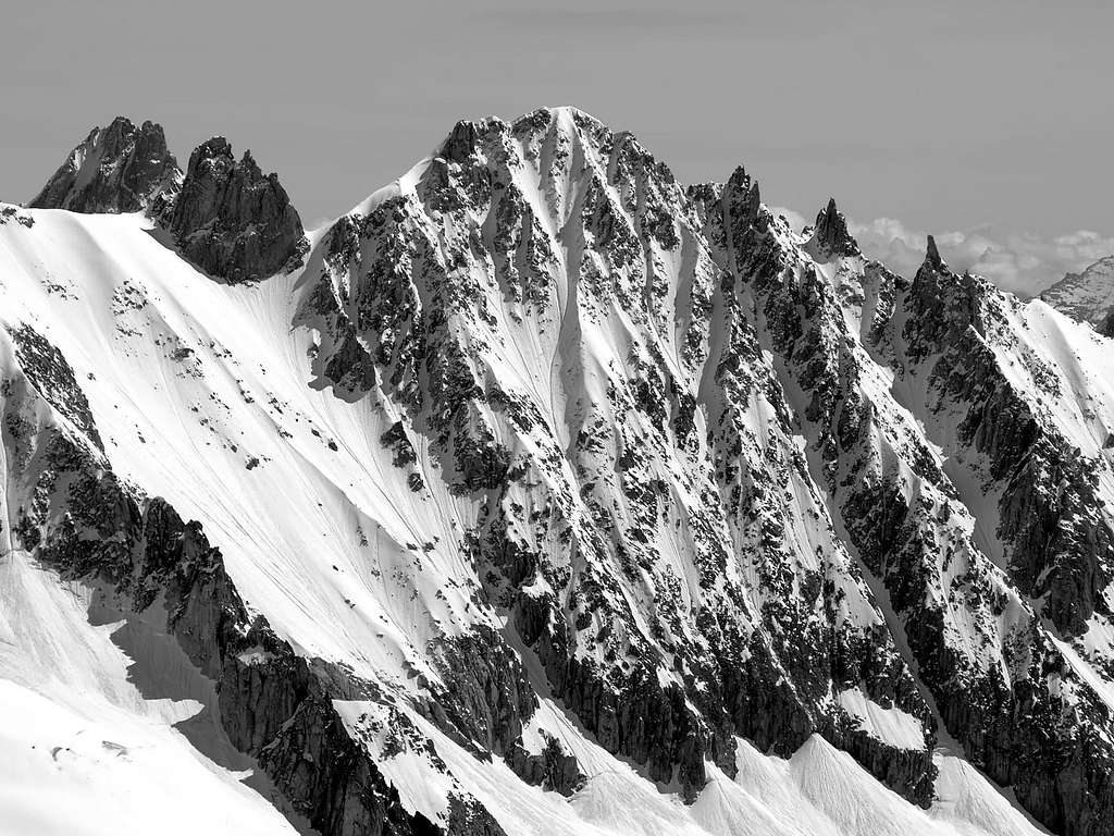
North face
All these routes are better climbed in spring or early summer. In fact because of the global warming that makes this wall very dry during the summer season, the current trend to climb these routes is to do it in spring or at most at the beginning of summer, using skis for approaching and sometimes also for the descent.
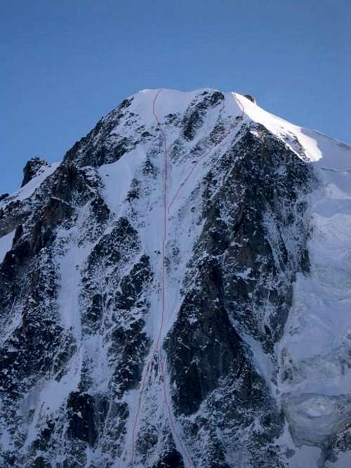 Les Courtes North face - Swiss Route
North-East slope (AD, Seriousness III, 700 m ) - The easiest route of the North wall
Austrian Route (D+, III, Seriousness IV, 850 m)
- Another well known ice-climb is the Swiss Route (TD, Seriousness IV, 800 m ) - First ascent: C. Cornaz and R. Mathey, 1938, july 31
The most challenging route of the wall. Before the introduction of modern ice climbing equipment, it was considered one of the most difficult North wall in the Alps. It is still one the classic ice-climb and highly recommended.
Approach: The face is approached from the refuge d'Argentiere in about 1 or 1 and a half hours to the base of the bergschrund. Another option is to aprroach by ski in from the Grands-Montets cable-car upper station.
Cross the bergschrund on the North Face proper and climb the first third of the face straight up to where the couloir narrows: first on steep snow 50°/55° and then on ice to 70°/75°for about 60 meters at the end of the first third of the wall. Above this ice crux section the couloir widens and the angle decreases back to 50°/55° ice and hard snow with a second wall at 65°for about 20 meters. There are two possible endings in the upper section, either exit right and join the NNW ridge to the summit or go straight up to the summit for the steeper exit option.
Descent: the more common exit is to descend on the back (South side) via the Normal Route to the Talefre glacier and then to the refuge du Couvercle (many crevasses).
Red Tape
There is no limitations whatsoever: Climbing, camping, beeing happy: just enjoy !
Huts
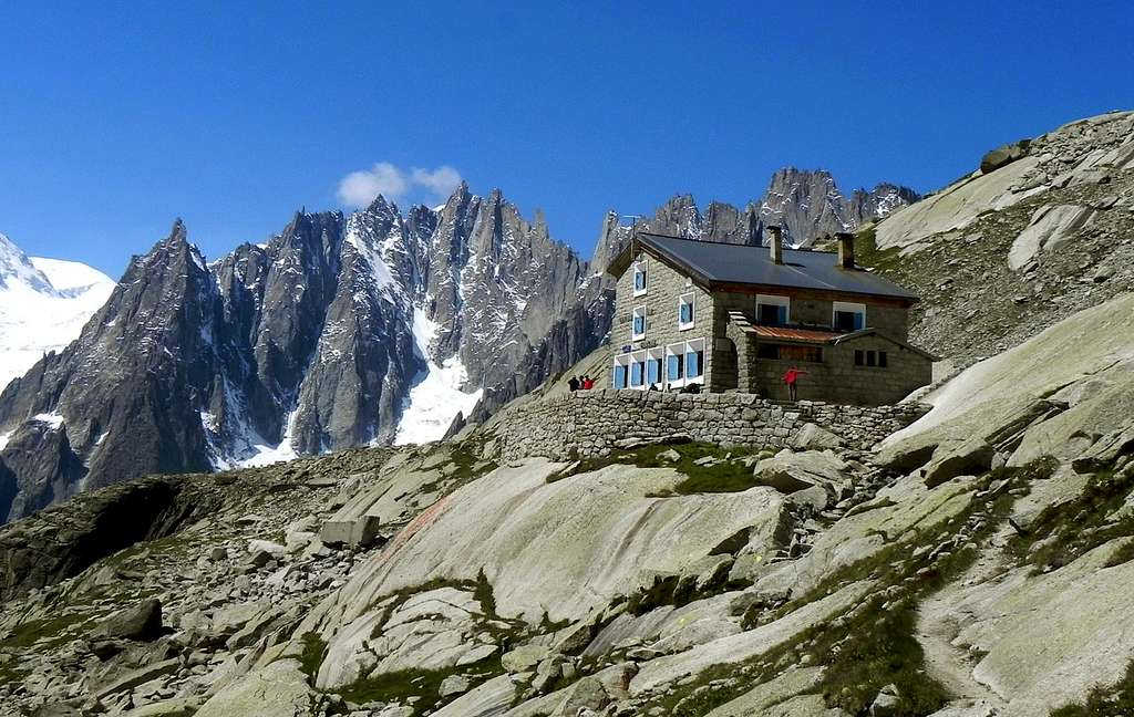
 Refuge d'Argentière
- Refuge d’Argentière 2771 m - C.A.F – 150 beds, open from February to May and from June to September. Winter-hut (20 beds), phone +330450531692 Situation: Mont Blanc group - Northern shore of Argentière Glacier. Open: from beginning of March to middle May and from middle June to middle September Size: 100 persons + 20 in the winter-shelter Getting there: from Argentiere by the Grands Montets cable-car, then by walking Hut's phone : +33-0450531692
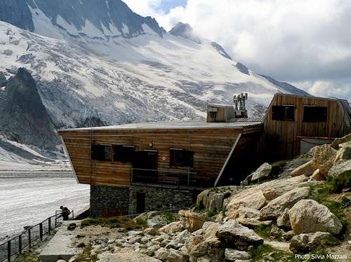
- Refuge du Couvercle 2687 m - C.A.F.
The refuge is placed at an altitude of 2687m on a balcony dominating the "Mer de Glace". The new refuge was built recently to replace the legendary old shelter made of sheet metal placed under a huge slab of granite as a shell (from that the origin of the name which literally means "shelter of the lid"). Its location allows the approach to all the peaks that surround the Talèfre basin, or as a rest for who come from the Argentiere side. In addition to this, it is situated in a location wherefrom the view of the mountains around is one of the most fine in the whole alps arch (Aiguille Verte chain, North wall of Grandes Jorasses and Mont Blanc massif). For this reason it is reached even without mountaineering purposes. Hut's phone: +33-0450531694
The Refuges should be reserved during most parts of the year.
Approach to the Huts
To the Ref. d'Argentiere There are 3 choices (depending on your time and energy)
- From Croix de Lognan (1970 m) in 3 - 3,5 h, to Croix de Lognan with cable car from Argentière: From Croix de Lognan, you go on foot up over the moraine crest till about 2250m. Than you continue horizontally to the glacier, which you follow on the orographically left side. After about 1 km, the glacier becomes steeper and more torn. You climb onto the morain of the Rognons, first over a slippery shelf, than via a marked way which you follow until you reach the upper end of the ice break. You climb the glacier with SE-direction and reach the hut above the moraine .
- On foot from Argentière in 5 h: From the ground station of the cable car, you follow the wide aisle of the ski-run. You leave it at the height of about 1750m and reach the way of the middle station of the cable car (2 h). Now, you need 3 h to the hut.
- From Aiguille des Grands Montets (summit station of the cable car from Argentière; last train up: 4:45 p.m.) in 2 h: From the summit station, you go via a stairway to the Col des Grandes Montets. You traverse a bergschrund (maybe with the help of a rope) and go up the steep hang to the Glacier Rognons. You go with ENE-direction on the western side along P. 3000 to P. 2754m. You go down southeastern to the glacier d'Argentière, which you reach above the icebreak. From here in 2 h to the hut.
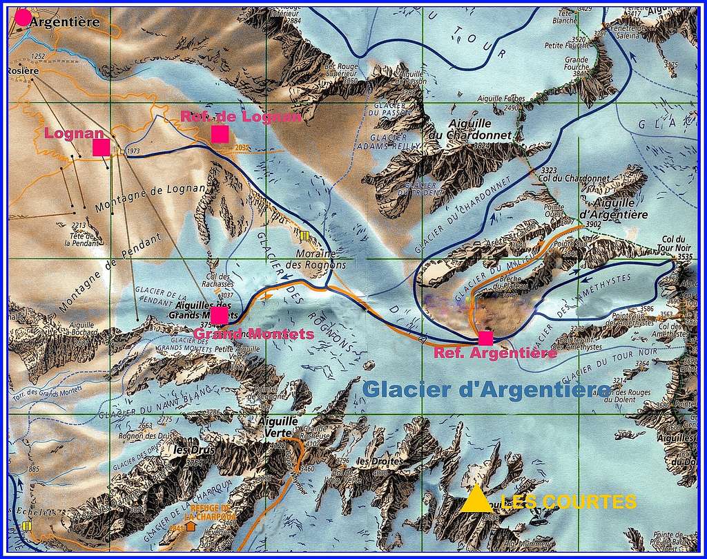
To the Ref. de Couvercle
- You reach the hut from Montenvers in 3,5 h over the glacier: From Montenvers to the starting point of the hiking way to the Ref. d'Envers des Aiguilles: You have to follow the way with direction to Les Echelles which goes slightly down to the western side of the Mer de Glace. But before you enter the Glacier, you have to follow the way on the western side of the glacier for about 20 min. Now you have to go up the glacier first more on the western side, then just through the middle with SE direction to Les Moulins. Now you do not follow the marking signs to the moraines but
continue with S and then E direction to the steep passages at Les Egralets (partly a little bit like a way). You go the steep passages up and via a good way through grass hangs to a moraine, from which you reach the hut soon. You can reach Montenvers:
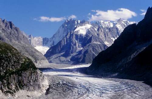
![Mer de Glace and Grandes Jorasses in the background]() Mer de Glace and Grandes Jorasses in the background
Mer de Glace and Grandes Jorasses in the background- Either with the special Montenvers-train from Chamonix. The train goes the whole year except from the middle of November till the middle of December. The first train starts during the season often not before 8 a.m., the last train down not after 6.30 p.m.
- Or on foot from Chamonix on the marked way via Biollay in 2,5 h.
- Via a new climbing track below the Flammes de Pierre and the ends of the Aig. du Moine: Note: Because of ice avalanches, some passages of this route have become very dangerous. You have to ask for the actual conditions.
Other accomodation
Hotels: Plenty in Chamonix and Argentiere, prices rather steep. Chamonix is a primary destintion, offering several accomodations (hotels, huts, gites, renting rooms). Numberless official campground are situated both in the Northern and Southern ends of the town.
Main campgrounds:
- Camping Glacier d'Argentière - Argentière (8 km. North to Chamonix) +33(0)450541736 - Camping la Mer de Glace - Les Praz (3 km. North to Chamonix) +33(0)450534403 - Camping les Deux Glaciers - Les Bossons (3 km. South to Chamonix) +33(0)450531584 - Camping les Arolles - close to the centre of Chamonix - +33(0)450531430 - Camping les Cimes - Les Bossons (3 km. South to Chamonix) +33(0)450535893 - Camping les Marmottes - +33(0)450536124
Camping on the Mountain can be done, but try not to annoy anyone.
When To Climb
A real winter ascent would be quite hard, but the conditions e.g. even beginning of November 2001 were just fine.The North Face is steep enough that not too much snow is sticking to it, but not as steep as the Droites. After a strong snowfall, you should wait for the next time it gets a little warmer, and the first avalanches will clean out the face again.
Guidebooks
- Neige, Glace et Mixte - 500 itinéraires dans le massif du Mont Blanc - François Damilano, Godefroy Perroux - Ed. Connection - ISBN 9782950986801 - in French
- La Chaîne Du Mont-Blanc, sélection de voies. Tome 2, A L'Est Du Col Du Géant - François Labande - Ed. Arthaud Guide Vallot GHM 2005 - ISBN 270030568X - in French
- Ascensions au pays du Mont-Blanc - Jean-Louis Laroche, Florence Lelong - Ed. Glénat 2000 - ISBN 2-7234-2556-8 - in French/p>
Mountain Conditions and other useful information
- Office de la Haute Montagne de Chamonix Phone +33 0450 532208. It offers a comprehensive information service about routes and weather conditions. Located in the building adjacent to Èglise-St.Michel church, 9:00-12:00 & 15:00-18:00 during the summer. Office de la Haute Montagne
- Cable-car informations Phone +33 0450 532275 Compagnie du MontBlanc
- Office du Tourisme de Chamonix Phone +33 0450 530024 Chamonix Mont-Blanc
Information can also be gotten from the Bureau des Guides in Chamonix (+33-(0)450 530 088).
Tel. weather bulletin +33-(0)836 680 274 Tel. state of snow +33-(0)836 681 020
Meteo
CHAMONIX METEO
METEOSWITZERLAND
grynning - Mar 12, 2003 7:16 am - Hasn't voted
Climb & ski, march 2003Climbed the huge colouir with crampons (10.march 2003). Good snow until about above midway, but hard ice and some rocks for the last 100 height meters (left our skis here). Skied down ! An awesome experience ! The steepness is between 45 and just above 50 degrees. Only to be skied/climbed in good snow conditions.