
Comments
No comments posted yet.
|
|
Trip Report |
|---|---|
|
|
Aug 15, 2016 |
|
|
Hiking |
|
|
Summer |
August 13, 2016, I embarked on a five-day solo backpacking trip in the High Uintas Wilderness of Utah. This adventure would take me to the top of five peaks all with elevations over 13,000 feet. My target peaks were Trail Rider Peak (aka Ramp Peak) at 13,247 feet, Roberts Peak (aka Pyramid Peak) at 13,287 feet, North Emmons (aka Pinnacle Peak) at 13,068 feet, South Emmons (aka Glacier Peak) at 13,170 feet, and Mount Emmons at 13,440 feet. In the process I would hike 44 miles and climb over 7,000 vertical feet.
From my home in Orem I drove up Provo Canyon heading northeast to Heber. From Heber I drove southeast through Daniels Canyon. Passing by Strawberry Reservoir I drove an additional 42 miles to where the highway number changed from 40 to 191. Highway 191 took me to Roosevelt. At Roosevelt, to reach the Uinta River Trailhead 25 miles further along, I left the main highway and drove north passing through Neola. About three quarters of a mile shy of the U-Bar Ranch I encountered a gate across Uintah Canyon Road. To the left of the gate, I pulled into a big parking area complete with pit toilets.
I was pleased to find that in spite of being a Saturday there were only three vehicles in the parking lot as well as a couple of horse trailers. The total 150-mile drive from Orem had taken close to three hours. I was the only person present, which I figured was in sharp contrast to the situation at the popular Henry’s Fork trailhead where I could have instead launched the peak bagging adventure I was about to set out on.
The Uinta River Trailhead, where I was parked, is positioned at an elevation just shy of 7,800 feet. In comparison the highest of the three Chain Lakes resides at an elevation of 10,623 feet. As such I had over 2,800 vertical feet of climbing ahead of me along with 10 miles to cover between the trailhead and the lakes where I planned to camp this evening.
With lunch completed, at 12:02 p.m. I started hiking. The first three-quarters of a mile took me past the aforementioned gate then along the road up to the U-Bar Ranch. Entering the ranch, I followed a single-track trail which skirted along the ranch’s right (east) side while heading mostly north, parallel to the Uinta River. Just shy of 4 miles into the days hike I arrived at Sheep Bridge which resides at an elevation of 8,146 feet. Finding that only one hour and 23 minutes had transpired since I began hiking, I was pleased to realize that my 40-pound pack wasn’t slowing me down. Granted up to now the trail had been easy to follow and mostly over even ground. In the interim I had crossed paths with a friendly group of horse riders whom I assumed were returning to the trailhead.
Using Sheep Bridge to cross the Uinta River the trail turned left (west), then coiled its way up eleven switchbacks to 8,600 feet. As I moved up the switchbacks, I counted my double steps. One double step singly counts the forward steps of only one foot. Two of the switchbacks were over 600 double steps long, causing me to believe the trail had been designed with horses in mind.
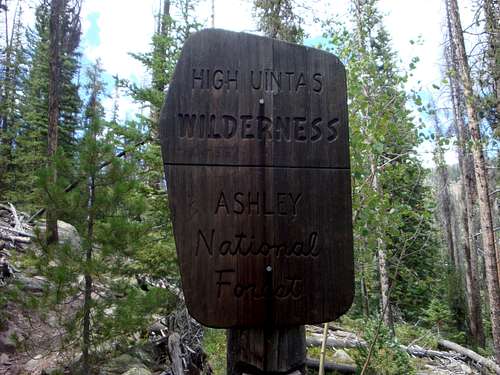
After the switchbacks the going became slower as the trail became very worn and rough with numerous loose rocks. As such I was forced to slow my pace. Using time as the basis, about a third of the way from Sheep Bridge to Lower Chain Lake I encountered a large sign announcing the Ashley National Forest; the time was 2:44 p.m. I thought it strange that the official forest boundary was so distant from the trailhead. This made me wonder what public land designation I was on prior to now. Shortly after encountering the Ashley National Forest sign, I crossed paths with a group of horse riders who were heading down. We acknowledged each other but didn’t pause to chat.
Upon reaching an elevation of 9,200 feet the trail headed mostly north until arriving at a crossing of Krebs Creek at 10,000 feet. Once I made the creek crossing the path headed mostly west, gaining another 580 feet as it guided me to Lower Chain Lake. At 5:00 p.m. I arrived at Lower Chain Lake’s dam situated at its southeast corner. The solitude of the hike had been wonderful, yet even more so here, at the lake, I truly felt alone and in a wild place. The information I’d read about Lower Chain Lake mentioned it had four established campsites as well as a backcountry pit toilet. However, the toilet and campsites snubbed me, compelling me to proceed northwest on the lookout for Middle Chain Lake.
Reaching the middle lake, I noticed a tent in the trees. As I got closer to the tent imagine my disappointment when dogs started barking. As a boy scout in the 1980’s I had been taught the etiquette and safety of keeping domestic animals out of wild places. Domestic animals, especially dogs, aggravate wildlife (as well as fellow campers/hikers) which may result in retaliation against both the dog and its owner.
At the risk of sounding insensitive, I must admit that I have always wondered if wilderness adventurers who bring a dog along do so to make themselves feel more comfortable about being in an untamed place. Is there some fear their pet guards them from? More likely, I suppose they simply enjoy spending time with their animal companion and have never been taught wilderness etiquette.
Notwithstanding the noisy dogs their owners didn’t appear to notice me, as such I basically had to shout at the camp to get their attention. When one of the three campers eventually responded, he wasn’t friendly. Rather than chatting I simply asked him the name of the lake, which he confirmed as the Middle Chain Lake. I also asked him if he knew about the pit toilet (as I wanted to validate the beta I had), but like me he hadn’t seen one either.
Ready to stop, but eager to get away from the dogs, I continued in the direction of the Upper Chain Lake. Before reaching the head of the upper lake I stopped again upon encountering a group of horses on the trail. The horse owners were busy fishing allowing me to approach them unobserved. As I got closer, I noticed one was wearing a gun in a holster around his waist. I reacted by making my presence known so as not to startle anyone.
The fishermen (three men and two boys) were friendly. As we chatted, I confirmed with them the name of the lake they were fishing, as well as Mount Emmons to the west and Roberts Pass to the north. They informed me that some of their group were from Vernal with the rest being from Roosevelt. I also learned they had their camp between the middle and the upper lake. When I grumbled about the roughness of the trail, I was informed that the prior year the dam at Lake Atwood had been redone. In the process, the plethora of horse trains needed to haul supplies back and forth between the Uinta River Trailhead and Lake Atwood had negatively impacted the trail.
In time, I excused myself by telling my new friends that I didn’t wish to disturb them and informing them that I would camp somewhere in the vicinity of the head of the upper lake. I doubt they cared about me disturbing them, likely it was the other way around. They told me to be safe.
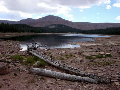
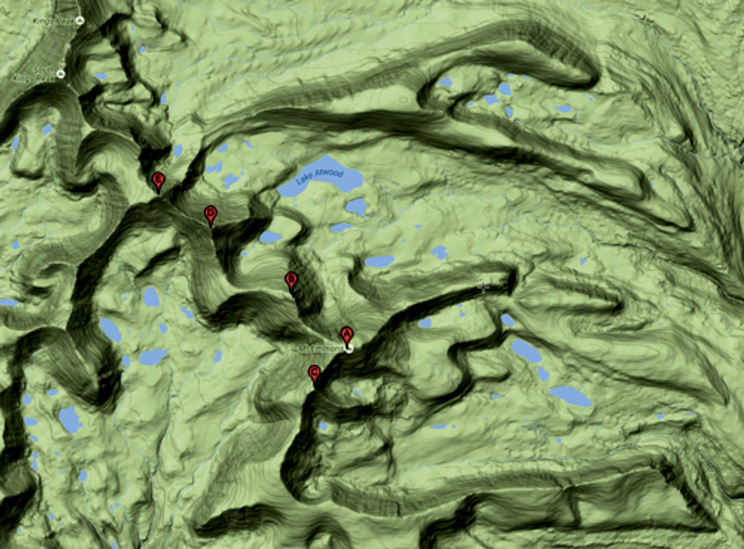
The Chain Lakes are three connecting reservoirs situated below one natural lake, the so-called Fourth Chain Lake, all within a two-mile span. The natural lake is hidden at about 10,880 feet. Due west, and about two and a half miles (as the crow flies) from Upper Chain Lake sits the monumental Mount Emmons reaching 13,440 feet in elevation. In spite of its vicinity to my first night’s camp, Mount Emmons would be the last of the five peaks I'd climb on this outing.
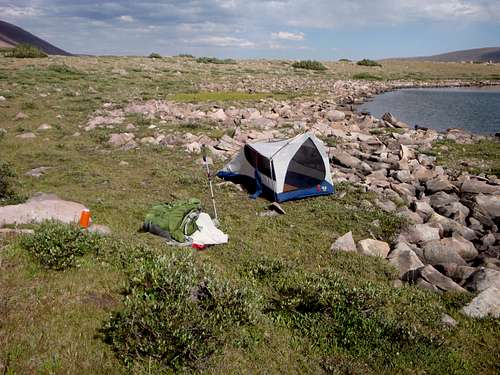
Just shy of the head of Upper Chain Lake I found an ideal camp spot in some pine trees slightly off the trail. Nearby a creek flowed into the lake. At 5:48 p.m. I dropped my pack, took a few steps to the creek, filled my bottles, returned to my pack, set down the bottles as well as my camera and sunglasses, and began to clear a spot for my tent. Suddenly, I noticed a bunch of bees swarming around my pack. Reacting, I dashed to my pack, quickly grabbing it as I bolted away with it. Having successfully evaded the bees, I decided to return to try to collect the rest of my things.
This time things didn’t go as smoothly. I only managed to grab a couple water bottles before the bees came for me. I ran as quickly as I could, and a good distance away, in order to escape their wrath. Next, I proceeded to cover myself up before returning to retrieve the rest of my items. Likewise, I decided to set up my tent just in case I needed to take cover. Fortunately, the time which passed in the interim gave the bees a chance to settle down. Thus, when I returned for the remainder of my things, I was able to collect them without further drama, although not wanting to push my luck, I made haste.
By 7:00 p.m. I had a fire going which I allowed to burn down to coals. Using the coals, I warmed up the tinfoil dinner I had packed in. After eating, I stuffed the remainder of my food into a bag and strung it up in a tree, alarmed with how heavy the entirety was. By 8:30 p.m., exhausted, I laid down in my tent, yet sleep didn’t bless me for some time.
Early in the morning, around 6:00 a.m., I climbed out of my tent to answer the call of nature. Given that I was up, I checked on my food bag. Gratefully I found the 35-year-old 5-50 cord used to elevate it out of the reach of wild animals had held overnight. All the same, I retrieved it and instead strung it up in a tree closer to my tent, where I could somewhat keep an eye on it. Returning to my sleeping bag I dozed off until 8:30 a.m.
As I made breakfast, and took down my camp, a spread-out group of four wandered by heading south. I believe only the last of the four noticed me and only because I asked her if she was part of a larger group. Subsequently, the dog owners I had encountered at Middle Chain Lake strolled by heading north. I reminded the last of the three that I was the guy one of them had spoken to the evening prior, yet again I received an unfriendly vibe.
By 10:26 a.m. I was ready to head out, with my destination being Lake Atwood located several miles away at an elevation of 11,030 feet. Initially the trail wound around the south end of Upper Chain Lake and from there it passed by the east side of Fourth Chain Lake. Gaining even more elevation, the route next climbed over Roberts Pass at approximately 11,120 ft.
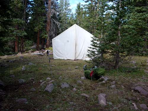
Fate may have been my guide (as will become clear later) when just before reaching the top of Roberts Pass, I turned west (left) and followed a faint trail north and soon mostly west. Along the way I startled a lone deer, prior to stumbling upon a white canvas wall tent skillfully hidden within a group of pine trees. Approaching the tent, I saw it was labeled "Ashley NF." I peeked inside noticing a pick, some buckets and water jugs. Although its occupants were not to be seen, I nevertheless noticed a puddle of water indicating someone had been there recently. With no reason to linger, momentarily I returned to Roberts Pass.
Traveling northeast I wandered done the pass’s northeast side. Before the trail turned to the northwest, I crossed paths with a five-horse train accompanied by two men and a boy. The leader asked me if I was alone, to which I replied, “yes it’s just me, myself, and I.” After two hours of hiking, I paused to eat part of my lunch. Afterward, at 1:24 p.m., I crossed the creek flowing out of Lake Atwood, using logs which were in place acting as a bridge.
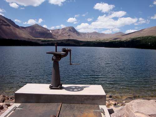
By 2:00 p.m. I arrived at the east side (the dam side) of Lake Atwood. Inscribed into the concrete platform I noticed the year 2015, corroborating what I'd been told regarding the dam having been recently rebuilt. Removing my boots, I soaked my feet in the water as I munched down the remainder of my lunch.
Consulting my map, I identified the five peaks I’d come to climb. All five reside along the same ridge – known as the Kings/Emmons Ridge. This ridge is the highest continuous ridge in Utah as it exceeds an elevation of 13,000 feet nine times. Its straight-line distance is 10.5 miles spanning the space between 12,700-foot Anderson Pass (the high point of the 104-mile-long Uinta Highline trail) and Flat Top Mountain at an elevation of 12,194 feet. On other outings I had reached the ridges southern peaks; namely Kings Peak (Utah’s highest natural point at 13,528 feet), South Kings Peak, Second Gemini (aka Peak 13,306), and First Gemini (aka Painter Peak).
The reason I hiked into Lake Atwood was to set up a base camp from which, without the load of my pack, I could then bag the five peaks over two days. The first day I planned to ascend Trail Rider Peak, and from its summit traverse to neighboring Roberts Peak before descending back to base camp. For the second day my plan was to climb back up to the Kings/Emmons Ridge and summit all three peaks of Mount Emmons, then again return to base camp. After reaching all five destinations I’d then pack up my camp and backtrack over Roberts Pass to the Chain Lakes, then return to the Uinta River Trailhead.
Eyeballing the ridge, a new plan started to form. I asked myself, “why not avoid backtracking over Roberts Pass, by instead dropping into Oke Doke Lake from Mount Emmons?” Likewise, I asked, “why climb twice up to the Kings/Emmons Ridge, if instead I could reach all five peaks in one big push?” If I did tackle the peaks as one big push ending at Oke Doke Lake it would mean a very long day, plus I’d have to lug all my gear over all five peaks.
Mulling over my peak bagging options, I wandered south to Lake Allred and from there west along the south side of Lake Atwood. Arriving at the lakes west side I found the time was only 3:23 p.m. – still too early to camp. As I continued exploring, I encountered some mountain goats which, to my amusement, I addressed in Spanish. After a while I wandered up to the unnamed lakes situated below Lake George Beard. Here I replenished my empty water bottles. Eventually, I decided I would do all five peaks tomorrow -- starting with Trail Rider Peak and dropping off Mount Emmons to Oke Doke Lake.
Needing to settle on a camp spot, I wandered over to Lake George Beard hoping to find some flat ground. On its northwest shore, I found what I was looking for which also seemed like a strategic location from which to commence my five-peak quest. I hoped to start the trek the next morning as soon as the sun was out. The plan was to first reach Trail Rider Peak and from there follow the ridge east over Roberts Peak then south and east to North Emmons then southeast to South Emmons, and finally northeast to Mount Emmons. I figured I’d reach Mount Emmons within eight hours, from which I hoped it would be a quick drop down to Oke Doke Lake. I believed the toughest part would be gaining the elevation from camp to the first peak of the day. Then from there it would be mostly ridge scrambling to reach the remaining four.
By 5:20 pm I had my camp set up. Having wandered approximately 20 miles over the last two days, a rest was in order prior to preparing my dinner. Crawling inside my tent I relaxed for the next hour.
Flanking my camp were some low scattered clumps of pine trees. Following dinner, I strung a line between two of the trees. To the horizontal cord I attached my food bag. The bag wasn't out of reach to bears, who were not a concern anyway, but it was high enough that marmots couldn't reach it. The sun dropped below the Kings/Emmons Ridge around 8:30 p.m. and I called it a day once again crawling inside my tent. Anxious for the next day, if was after 11:30 p.m. before I fell asleep.
I woke up several times in the night concerned that I may have overslept. When 5:00 a.m. eventually did arrive, I didn’t feel like getting up, but I did so anyway. It took me two hours to pack up my camp and prepare and eat my breakfast. Even so I still felt I would reach Trail Rider Peak by 9:30 a.m.
From the north end of Lake George Beard, I followed a path leading up to the 11,800-foot Trail Rider Pass. At the top of the pass, I turned south, following a 210-degree bearing, and began scrambling up a scree and boulder covered ridge originating from Trail Rider Peak. The higher I climbed the steeper the angle became. All the same, being full of energy, I kept up a rapid pace. Out of nowhere, suddenly graupel began to fall. Looking up I could see the highpoint just yards away, so I pushed on without donning my rain jacket. After barely one hour and forty-five minutes I found myself at an elevation of 13,247 feet atop Trail Rider Peak – one peak checked off, with four to go! The graupel soon stopped, yet much to my concern storm clouds were now hovering all around the Kings/Emmons Ridge. On the other hand, not sensing eminent danger, or seeing any threats of lightning, I turned southeast and started toward the next peak, praying that I would remain safe.
As I eyeballed the distance to my second objective the scramble appeared straightforward. Moreover, my energetic pace up to Trail Rider Peak had me believing I’d complete the 503-foot down climb to the saddle between Trail Rider Peak and Roberts Peak (my next objective) in no time. Encouragingly, from the saddle it was only 543 feet up to Roberts Peak! Combined, I estimated the down climb to the saddle and the up climb to the next peak would not need more than one-hour. Under estimating travel time is discouraging -- as was the case here -- when in fact it took two hours to boulder hop from Trail Rider Peak to Roberts Peak.
Following a quick snack atop Roberts Peak, four hours into the day’s journey, I began moving south down from its 13,287-foot elevation, aiming once again for a saddle. Dropping down nearly 800 feet burned another hour, while seeming like forever due to the difficulty of jumping from one wobbly boulder to the next under the added strain of a full pack. Upon reaching the 12,510-foot saddle, I lowered my pack and removed my boots, as a rest was in order. As I rested, I ate lunch.
By 12:40 p.m. I was moving again. Soon, upon starting up from the saddle’s trough, I turn left heading southeast at a bearing of 106 degrees toward the 13,068-foot apex known as North Emmons. Mercifully the climbing became relatively easy allowing me to reach the days third 13er by 1:20 p.m. Atop the pinnacle the weather took a turn for the worse when again graupel began to fall. In the near distance I heard thunder but did not see any lightning. This time the graupel did not subside quickly. Getting cold, I had to dig out my rain jacket.
As I descended to the next saddle, the wind picked up causing the graupel storm to fade away. Arriving at the 12,587-foot saddle between North Emmons and Mount Emmons, I faced a choice. From here I could climb up the northwest sloping ridge of Mount Emmons (the same ridge which forms the southeast spine of the saddle which I was presently at the low point of), or I could go directly south to South Emmons by negotiating the west facing slope below the span between Mount Emmons and South Emmons. The second choice would be a tougher stroll but had the advantage of less distance required to reach the two remaining objectives of South Emmons and Mount Emmons. Should I choose the less difficult course and go directly to Mount Emmons I would have to tag that peak twice since after reaching South Emmons a return to Mount Emmons would be needed to accommodate the planned descend to Oke Doke Lake.
Predictably I picked the shortest route, gambling it would save time. Once I got out of the wind, which had been an issue at the saddle, I paused for a needed rest. For a second time I removed my boots to give my tired feet a break. As I started moving again, I played it safe, trying not to worry about time, as I labored across, and up, the aforesaid west facing slope to South Emmons. Side-stepping across a steep slope, while gaining elevation – especially a chossy slope like I was traversing – is never easy. Plus, by now I no longer maintained the energy I had possessed up to Trail Rider Peak.
Finding the slope challenging, I adjusted my trajectory away from my 13,170-foot objective aiming instead for the 12,900-foot saddle between Mount Emmons and North Emmons. My hope was that the spine from that saddle to the peak would provide less demanding hiking – if nothing else, I hoped, once I obtained the saddle, I would no longer need to side-step. Achieving the saddle, I stashed my pack on its eastern side where I also found a band of snow leading up to South Emmons. To get a break from the relentless boulder hopping, even if only momentarily, I hiked on the line of snow, until it dried up shy of my objective.
My persistence of simply putting one foot in front of the other eventually paid off when two hours after reaching North Emmons, I stood on the day’s fourth objective; namely South Emmons. The time was 3:20 p.m. – meaning I was now twenty minutes over the eight hours I had hoped I could reach all five peaks within today.
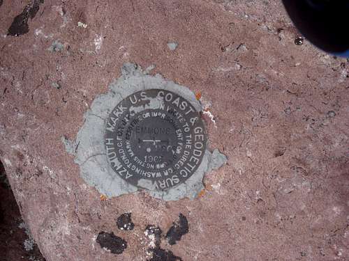
On the summit, I found an azimuth mark. The metal disk, about three and a half inches in diameter, was firmly cemented into a rock and labeled with “1962 Emmons.” An azimuth mark is a long-range reference survey mark that supports a primary station (aka primary survey mark). No doubt Mount Emmons would contain the primary station. Azimuth marks serve two purposes. First, they provide a point from which a surveyor can locate a primary station. Secondly when both a reference mark and a primary mark are located, the reference mark allows the surveyor to know the exact direction, aka azimuth, in which he is looking. As such, accurate measurements can then be taken. The reference mark I had stumbled on, being a long range one (aka an azimuth mark), was located a good three-quarters of a mile, as the crow flies, from the highpoint of Mount Emmons – an acceptable distance for a long-range mark to be placed from the primary mark.
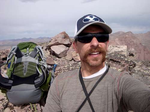
Traveling from South Emmons to Mount Emmons follows a northeast bearing of 34 degrees. Descending, of course, I took advantage of the snow just as I had on the ascent. Having dropped 270-feet, I hoisted my backpack and began climbing the 540 vertical feet between me and my fifth peak of the day. The stroll between peaks wasn’t as difficult as many of the others had been, allowing me to make it to Mount Emmons within 50 minutes. Of course, the actual walking distance exceeded the aforementioned three-quarters of a mile which was as the crow flies. After 9.5 hours of continuous effort, I had accomplished my goal of reaching five 13ers in one big push!
Even though my five-peak journey had taken longer than estimated, my progress was nevertheless impressive. With my fingers crossed I was optimistically confident that the descent to Oke Doke Lake would be quick and easy. I took the time to find and sign Mount Emmons summit register but anxious to get down to a comfortable campsite I didn’t bother looking for a primary survey marker. In the summit register, dated just one week prior to my entry, I noticed the signature of an acquaintance I had climbed the Eleventh Hour Route with on Sundial Peak in June of 2012. *Nowadays (as of September 2023) that same fella runs a YouTube channel called SUV RVing.
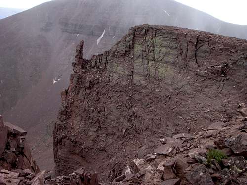
At 4:41 pm as I left the peak, I spotted what I figured was the same herd of goats I’d seen the afternoon before. Sensing me, they quickly took off. As I made the northeastward traverse across the Mount Emmons summit plateau, the distance seemed extremely long. I had to remind myself that the distance wasn’t really that far but rather since I had completed the task, I’d come to-do, I was simply ready to be done! For lack of better words, getting off the Kings/Emmons Ridge and down to Oke Doke Lake at this point seemed to me to be more or less a necessary evil.
From the northeast corner of Mount Emmons summit, I now faced a 35-degree scree and boulder covered slope dropping 1,400 or more vertical feet from my location down to a meadow located southwest of Oke Doke Lake. The only comfort I had was that it didn’t appear to be much more than a half mile to the meadow. Half a mile, or not, the trailless descent required deliberate slow steps, as the steep terrain proved to be dreadfully challenging. The endless boulder hopping became almost unbearable, but again relying on the simple persistence of continuing to put one foot in front of the other, eventually I entered the meadow. Overall, measured from the time I left Mount Emmons highpoint, the descent to the meadow took two and a half hours.
At the meadow I turned north toward Oke Doke Lake, momentarily renewed with the steep downclimb now behind me. As the lake came into view, my sense of jubilation was replaced by a flood of disappointment. Nestled in a small cirque, Oke Doke Lake dwelt at the bottom of yet another steep slope covered in boulders and scree, 600 feet below where I stood. Thirsty, hungry, and exhausted – having spent 13 demanding hours to get this far – I wanted to give up. Apart from the fact that I was out of water, I for sure would have made camp where I stood; discouraged as I now was. With no options, I accepted fate and began picking my way down the barrier. Within an hour – putting the time at 8:00 p.m. – at last I reached the southern shore of Oke Doke Lake.
As the first order of business, I filled my water bottles, then set them aside to allow the iodine tablets I’d placed in each bottle time to do their job. Looking around I saw only rocky, wet, or sloped terrain, so there was no need to unpack my tent. Consequently, I pulled out my Jetboil and prepared instant noodles.
In the dark, at 8:50 p.m. I once again hoisted my backpack and started walking to the east across rocky, treeless terrain in search of a smooth spot to pitch my tent. As I searched, aided by the limited light coming from my headlamp, the white wall tent I had mysteriously stumbled upon yesterday came to mind. Reckoning that it had to be close, I immediately decided to find it, figuring it was the best place around to camp.
Before long I heard a dog bark which made me believe I’d find the wall tent camp occupied. Not long after that my light caught a shimmer off something. Bending down to pick the object up I found it was a piece of glass from a broken bottle. As I straightened back up I noticed a white canvas wall only yards in front of me.
Calling out, I asked if anyone was in camp and informed any listeners that I had heard their dog. No one replied, and nothing stirred. I took a few steps closer and again nothing stirred. Who knows where the dog was I’d heard bark, but he wasn’t here. Sighting a nice smooth flat spot next to the canvas tent, I didn’t hesitate and soon had my tent erected. As worn out as I was, I elected to leave the fly off. Before crawling into my tent, I strung a line from a corner of the wall tent to a nearby tree. To the line I had attached my food bag.
Fifteen hours I’d labored, and I was now beyond exhausted from what I estimated to have been 13 miles of marching while crossing five peaks above the 13,000-foot elevation mark. With all the ups and downs I’d certainly climbed over 4,000 feet of elevation in the process. Overall, descending those 4,000 vertical feet had been the hardest part.
As I lay in the tent, I heard horses snorting, and there seemed to be the hum of a generator in the air. Clearly, another camp was nearby. Why then, when I had called out, had no one replied?
Inevitably, I had to get up and install the fly, as I found it too cold inside the tent without it. Sometime after 10:30 p.m. sleep overtook me.
At dawn I awoke to the sound of horses passing by my camp. Too tired to get up, I attempted to fall back to sleep. Then a second time I heard the horses. Worried that someone might be arriving, and could see me as an intruder, I decided to get up. Except for using the wall tent as an attachment point for my clothesline, I had not disturbed the camp in any way. However, as overly conscientious as I am, I took down my food bag and unattached the line.
When after a reasonable amount of time had passed and no one had arrived, I crawled back into my tent. However, by now I was awake, and nervous from the noises I’d heard, so I soon got up.
Before doing anything else, I first looked around for the other campers but couldn’t locate anyone. It was so weird, because I had heard both a dog and horses, plus a manmade noise that sounded like the hum of a generator. I guess the generator could have been a vibration or an echo? Perhaps the bark had come from a coyote? Back in 2008, while camping at Dollar Lake, mooses woke me in the night, and before seeing them I assumed a group on horses had arrived. Did this morning involve a similar case? Likewise, the “horses” might have been elk or deer.
After breakfast I grabbed my water bottles and wandered off in search of a stream I’d seen when I first stumbled across the wall tent camp. Finding it, I didn’t like the look of the water as it was very shallow. Planning to pack up soon and head down to the Fourth Chain Lake, I decided I could get by with the water I had.
Back at the wall tent camp, I located the broken glass that had alerted me the night before. Adjacent to the glass, I found two matted down spots both about the size of a one or two person tent. No one was camped there at 9:30 p.m. when I’d arrived the night before, but someone or something had been there recently. This explained the “horses” – probably elk, as the matted spots were a bit big for deer.
At 9:05 a.m. I was packed up and on my way to the Fourth Chain Lake. As I was about to connect with the trail leading to the lake, I heard a man talking loudly. Arriving at the trail I noticed a set of large boot prints going toward Robert’s Pass, as well as a set of smaller (lady sized) boot prints. The large prints I guessed belonged to the voice I had heard.
At Fourth Chain Lake I washed my feet and relaxed. Eventually I prepared an early lunch, after which I built a fire. The purpose of the fire was to shed some weight from my backpack by burning my garbage. During my time at the lake the unfriendly dog owners I’d encountered at Middle Chain Lake strolled by heading south. As they passed by, they must have seen me, but by now I knew they were unfriendly, so I ignored them. If not a coyote, perhaps it had been one of their dogs I’d heard barking the night before?
My plan for the remainder of the day was to make my way down to Sheep Bridge. Although from there it would only be about an hour and a half to walk to my vehicle, I thought it better to save that short hike for tomorrow. Afterall there was no advantage to reaching the vehicle today, as it would be dark by then, and I was not about to drive home in the dark.
At 11:40 a.m. I started moving again. Upon reaching my first night’s camp, I retrieved some garbage I had stashed under a rock. Not being under any pressure, I decided to add some variety to my walk by strolling around the west side of Upper Chain Lake and from there to the dam at its southern end. From Upper Chain Lake’s dam, I walked through the trees skirting by Middle Lake. Eventually I joined back onto the main trail near the northwest end of Lower Chain Lake. Arriving at the Lower Chain Lake dam, I stopped and prepared some more food.
Following my rest, I snapped a photo of Mount Emmons and South Emmons as seen looking over Lower Chain Lake. As I started walking, I estimated it would take me three and a quarter hours to cover the 5.6 miles to Sheep Bridge, and by now the time was 2:35 p.m. Within one hour I reached the Krebs Creek crossing. The water was too inviting, enticing me to remove my boots and soak my feet. At 4:46 p.m. I passed by the Ashley National Forest sign – from there it took me under an hour to reach the first of the switchbacks. Approaching 40 miles of combined hiking distance over the last four days my feet were feeling it, so yet again I removed my boots.
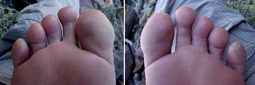
Less than 30 minutes behind my projected arrival time, I reached Sheep Bridge. On the west side of the Uinta River, back in some spaced out trees, I found an ideal camp spot. Soaking my feet in the river felt especially great, as by now blisters had formed on both of my little toes. After dinner I made a fire to burn garbage again.
Once the sun went down, I had no reason to stay up, so I hit the hay. During the night I tossed and turned having strange dreams about my job and the people I work with. Also, I woke up with an upset stomach, because of having eaten a freeze-dried “Beef Stroganoff” meal for dinner. Around 3:00 a.m. I got up and took a Pepto Bismol tablet then brushed my teeth.
Having suffered a restless night, I took my time in the morning. At 10:00 a.m. I began the last leg of my hike. Within an hour and a half, I arrived at the U-Bar ranch, and in 10 more minutes I reached my car. Although not the same two cars, there were again two cars in the parking lot in addition to mine. A couple cowboys were unloading horses from a horse trailer. Thankfully, my car was as I left it, and the water inside was cold.
Overall, I walked 44 miles, reached five 13,000 plus foot peaks, and climbed up and down around 7,000 vertical feet. The amount of bolder hopping across and down the Kings/Emmons Ridge wore on me, as did the roughness of the run-down trail to-and-from the Chain Lakes. The most challenging part of the outing was the descent down Mount Emmons to Oke Doke Lake. I really enjoyed the solitude and was fortunate that the graupel storms I’d encountered high up had not involved any lightning.