
|
|
Mountain/Rock |
|---|---|
|
|
43.28340°N / 85.61275°W |
|
|
Kent |
|
|
Hiking |
|
|
Spring, Summer, Fall, Winter |
|
|
1075 ft / 328 m |
|
|
Overview
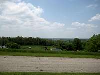 South view from Fisk Knob
Fisk Knob is the highest point of Kent County in Michigan. Since it is of interest to county highpointers, I decided to give it its own page. Also, it has a decent view for western Michigan over the surrounding countryside. There is a small, open park surrounding Fisk Knob (4 acres).
 Northwest view from Fisk Knob (note the landmark tower)
 Fisk Benchmark
It is interesting that Fisk Knob is not a USGS name, but the name "Fisk" probably came from the USGS benchmark located at the summit.
Getting There
Getting to Fisk Knob is not difficult. It is located on the north edge of Kent County, just west of where three counties (Kent, Montcalm, and Newaygo) meet. Also, it is close to a major highway, US-131. From US-131 exit 110, go west on 22 Mile Road a little more than 3 miles to Algoma Avenue. Turn left (south) onto Algoma and drive less than a mile to the parking area for Fisk Knob, on the right. The tower (cell, I think) is a good landmark, the parking area is right after that property. Also, the parking area is at the highest point of Algoma. Also, for North Country National Scenic Trail (NCT) hikers (who might also be county highpointers), Fisk Knob is located about 4-5 miles east of the trail. The closest road point is where the NCT enters/exits the north edge of the Rogue River State Game Area on 22 Mile Road at Oak Avenue.
Red Tape
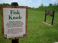 Park signs
All parks in Kent County open at 7 am and close at dusk. There is no charge for parking. Picnicking is allowed, but there are no services. No camping is allowed.
Maps
USGS 7.5 x 7.5: Sand Lake
North Country Trail, map MI-03, 76th Street to M-37 (not labeled)
External Links
https://www.kentcountyparks.org/fiskknob/index.php
Fisk Benchmark entry at Peakbagger
Kent County entry at County Highpointers