
|
|
Route |
|---|---|
|
|
37.13600°N / 118.6828°W |
|
|
Trad Climbing |
|
|
Summer |
|
|
A few days |
|
|
5.9 (YDS) |
|
|
VI |
|
|
Overview
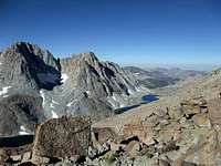
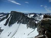
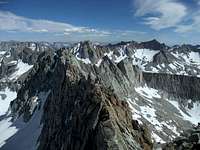
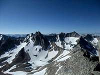
Listed by Peter Croft as his favorite traverse, Evolution is a highly coveted ascent. It is also one of the most elusive, guarded by a relatively difficult approach and having a length of 8 miles. Contrast this with Thunderbolt to Sill (a popular Sierra traverse), which is ~1.6 miles. The traverse crests nine 13,000 ft peaks, offering spectacular views of Evolution Basin and Darwin Canyon. Even if you only have time to finish a portion of it, it's well worth the effort.
History Evolution Traverse proper was completed by Peter Croft in June of 1999. He had completed two variations prior: Mendel to Huxley with Galen Rowell in July 1997, and 13,360 to Haeckel with Dayle Mazzerella in August 1998. Michelle Peot completed the first female ascent solo in August 2011. The first winter ascent was completed in March 2012 by Shay Har-Noy, Ben Horne (RIP), and Konstantin Stoletov.
Getting There
 |  |  |
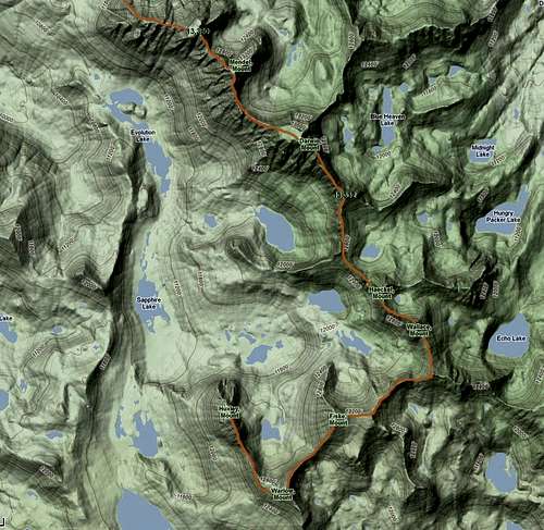
From Bishop take Hwy 168 (aka West Line Street) west through the town of Aspendell to the North Lake turn, which will be on the right. The turn-off is ~18.2 miles from the intersection of Highways 395 and 168. Note that the road closes seasonally. Take the North Lake road ~1.6 miles to the hiker parking, which is near the pack station. Parking past this turn is reserved for campground residents. There are pit toilets at the parking area.
From the hikers parking walk through the campground to the Lamark Lakes trailhead, which is shared with the Piute Pass trail. The turn-off to Lamark is shortly after the trailhead. Take the Lamark Lakes trail past Lower Lamark Lake. Just before Upper Lamark Lake you will find a cross-country trail that heads left (slightly southwest) from a packers camp. The trail switchbacks up the steep hillside to the south. It is heavily used though still considered cross-country. The trail continues around the base of some steep cliffs before angling true southwest up the long sandy drainage that leads to Lamark Col. There are good bivy sites here. Pass the tarn below the col on the left (south side). The col is above the tarn (slightly southwest). There is a sign that marks the top of the col, but you can't see it from the tarn. Enjoy what may be your first glimpse of a small section of the traverse. Take note of the landmarks at the top of Lamark Col for the return trip as it's not obvious from the Darwin Canyon side and there are many trails. It is not advisable to try the cross-country portion in the dark if you are unfamiliar.
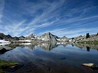
From the col take one of the many use trails into Darwin Canyon. Follow the trail along the right side of the lakes, heading west. As you hike down the canyon note the position of the 13,360 summit relative to the start. The summit is a long way from the start, longer than the distance between any of the subsequent summits. Keep this in mind to avoid any early discouragement. You can either continue on the trail or for a more direct route, once past the last Darwin Canyon lake cross-country to the flat area (Darwin Benches) at toe of Peak 13,360. There are many good campsites here with a lake and streams for water. Most parties spend at least a night here prior to attempting the traverse. It's worth spending more if you need the acclimitization; the views are spectacular.
Total approach distance: 10 miles
Route Description
There isn't an exact way to go (and no, I don't have GPS waypoints). A general rule is to stay fairly near the true crest when possible. There are many versions of beta online so take them with a grain of salt (including mine).
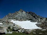
13,360 (aka Gould) There are a number of ways to ascend 13,360. I have approached from both the right and left sides and found the left to be more direct. The right drops you into a deep notch from which you'll have escape. Knowing that the first "summit" you see from camp is false I contoured around it. The climbing on here is mostly class 3-4; you may encounter a few moves of low class 5 if you take the most direct line.
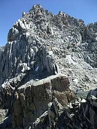
Mendel From the summit of 13,360 follow the ridgeline. You are aiming for the ~25 ft tall fractured headwall on Mendel (see photo). The easiest line is 5.6. Mellow climbing leads to the summit.
Darwin From Mendel follow the picket fence (5.8) to the huge, flat Darwin summit.
13,332 This section contains the crux, which for me was a 35 ft 5.9 handcrack, which I rapped. From the Darwin summit block make your way down through chimney system on the right (SW) side of the ridge proper. I downclimbed a chossy 5.6 section to reach the chimneys; there may be other options. After the chimneys most people end up traversing the 5.7 golden wall, which from the way I went down involved working you way out left. Continue on blocky terrain, possibly with some 5.8 face moves. Just before the 13,332 summit I cliffed out above the 5.9 handcrack. Judging by the rap slings I was not alone. After this follow easy terrain to the summit.
Haeckel If you need water, the lake below Haeckel is the closest guaranteed place to get it. From 13,332 follow the class 2-3 ridgeline to the headwall below Haeckel. Take the short class 4 headwall to easier class 2-3 terrain leading to the summit.
Wallace Refer to Bob's description here.
Fiske-Warlow More class 3 terrain along the ridgeline with easy routefinding over somewhat nondescript peaks.
Huxley From Warlow follow easy terrain to the obvious headwall on Huxley. I went up the headwall and found it ~5.7. You could go up one of the easier, chossier chutes but you'd loose a bunch of elevation. There are a number of ways to reach the summit from here, but expect some moves up to 5.8 depending on which way you go.
 |  |  |  |  |
Descent
From the summit of Huxley there is a gully that drops due west to the John Muir Trail. There were a few short, low class 5 downclimbing moves but otherwise it was class 3-4. Hike the JMT north through Evolution Basin as you pass the hoards of backpackers, who have no clue what you have just done. About 0.6 miles past Evolution Lake the trail will descend slightly though a wooded area. Look for a trail on your right heading up to Darwin Canyon. It had a laminated sign as of Aug 2011.
Distance back to the Darwin Benches: ~6 miles
Essentials / Gear to Consider
Water Once on the route proper there is no guaranteed source of water. Options include melting snow or dropping ~500' down to the lake below Haeckel. Several people, including myself, used a dark water container strapped to to the outside of their packs to melt snow along the way.
Gear This is the trickiest part especially if there's a decent chance you can daytrip the route. Having the extra weight of bivy gear slows you down, but it's also the more prudent option if you don't want to spend a miserable night huddled on the ridge. Even with pleasant daytime temps it may still get down to freezing at night so plan accordingly.
- alpine rack including long slings
- light rope
- webbing/rap rings
- approach +/- climbing shoes
- ice axe (possibly just for the col, condition dependent)
- bivy stuff
When to Go / Red Tape
Most people will attempt this route in summer when days are long and the approach/descent is relatively snow-free. August and September are the most stable weather months in the Sierra, but many successful attempts have been done earlier. A number of people have completed the route in a day (including the approach); all are strong, fast soloists, at most rapping only the 5.9 crux between Darwin and 13,332. Most parties will spend 2-3 days on the route and rope up for the harder sections. The obvious bivy spots are the huge summit of Darwin and near the tarn below Haeckel (the only place with guaranteed water), but there are also small ledges and other flattish sandy spots along the way.
You will need to obtain a wilderness permit for overnight trips. The area is popular with backpackers so reservable quotas fill up on summer weekends.
External Links & References
Recommended Longer, Warm-up Routes- Thunderbolt to Sill
- Temple, Galey, Sill (ideally continuing on to Thunderbolt)
- Cirque of the Towers Traverse
Trip Reports
- Shay, Ben and Konstantin's first winter ascent trip report
- Alex Few and Jed Porter's trip report
- Michelle's first chick ascent trip report and Neptune Mountaineering slide presentation
- Ryan Huetter's trip report
- Warren Caldwell and Dave Johnson's trip report
- Shay's first attempt trip report
- Dan Patitucci's trip report
- Sean O's car to car trip report
PM me if you'd like to have your TR added.