
-
 15418 Hits
-
 92.59% Score
-
 39 Votes
|
|
Route |
|---|---|
|
|
45.92711°N / 7.87613°E |
|
|
Mountaineering |
|
|
Summer |
|
|
A long day |
|
|
Alpine D, IV- UIAA |
|
|
Overview
Cresta Signal – Signal Grat or East Ridge
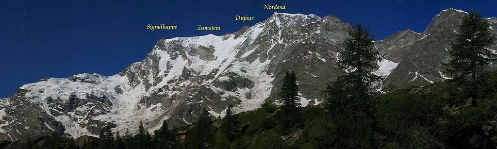
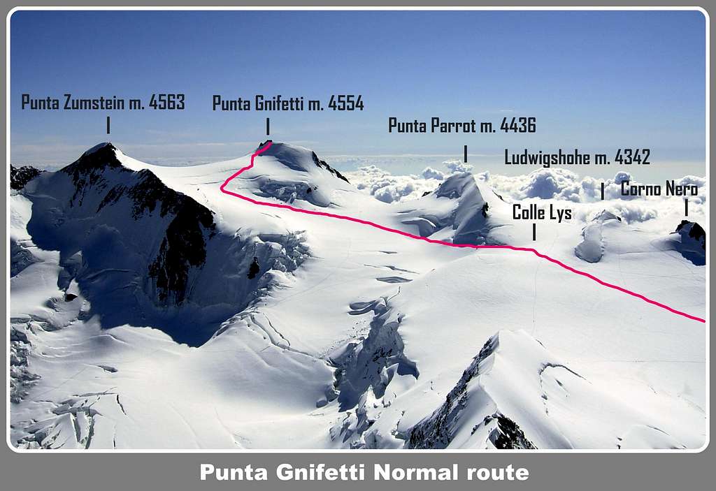
Amongst the four main summits of Monte Rosa group, Punta Gnifetti 4554 m is the lower one, after Punta Dufour, Punta Nordend and Punta Zumstein. Punta Gnifetti is usually climbed along the Normal Route - an interesting and very attended itinerary – running on the Western side of the mountain and involving an easy and varied ascent on the gently angled Lys Glacier, then on the Grenzgletscher in its upper part.
On the contrary Punta Gnifetti shows in its Southern side a high, steep and wild face, overlooking the Valsesia. A great ridge facing East is rising on the right hand side of this magnificent rocky wall, starting from Colle Signal; it separates the basin of Alagna (Valsesia) on the South-East side from the basin of Macugnaga (Valle Anzasca) on the North-East one.
On this fine ridge facing East it runs one of the most attended middle grading routes in the entire Monte Rosa Group: the Cresta Signal, a great classic mixed course. It can be approached from Alagna Valsesia by a long itinerary inside a wild and spectacular environment.

History
First ascent: Harold W. Topham with Aloys Supersaxo and a porter 1887, july 28th
First winter ascent: Ottavio Festa and Adolfo Vecchietti 1948
Getting There
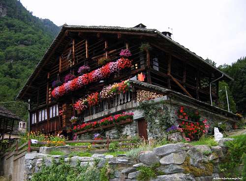
Traditional house in Alagna Valsesia
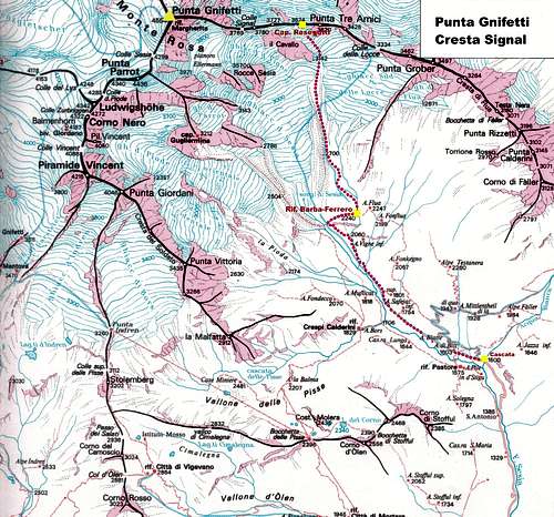
The starting point is the village of Alagna Valsesia m. 1186 (Valsesia, Piedmont), an important touristic center lying at the end of Valsesia, at the foot of the Southern side of Monte Rosa group.
Road Approach to Alagna Valsesia
- From Milan
Follow the A4 Motorway, then the A26 Motorway, exiting Greggio. Follow the road 299 rising along Valsesia, reaching Borgosesia, Varallo, Scopello and Alagna Valsesia m. 1186 (62 km. from Romagnano Sesia).
- From Switzerland
You can reach Domodossola through the Simplon Col, then follow the A26 Motorway and exit Gravellona Toce. Follow the road 229 towards Omegna and Varallo; here take the road 299 to Alagna Valsesia.
From Alagna Valsesia m. 1186 a road gets to the Acqua Bianca fall (1500 m.), after about 4 km., ending here. Private cars are not allowed to follow this road in full season; a minibus service starting daily from Alagna is available to get the Acqua Bianca fall, where the path to Rif. Barba-Ferrero starts.
Walking Approach to Barba-Ferrero Hut m. 2247
Follow the steep path rising to the meadows named Alpe Fum Bitz m. 1603, leaving on the left hand side the path to Rifugio Pastore. Continue on the right getting to Alpe Blatte m. 1635. At about 1860 meters cross a stream (huge block), then a second one, and rise to the left edge of a great cliff. Leave again on the left the trail to Capanna Gugliermina and follow the steep path on the right, getting to upper Alpe Vigne, a beautiful panoramic point over the southern side of Monte Rosa group and its wild summits. The approach walk requires about 2,30 hours from the parking near the fall.
Cresta Signal report
Cresta Signal report - UIAA Scale
Summit altitude: m. 4554
Difficulty: Alpine D, IV- UIAA
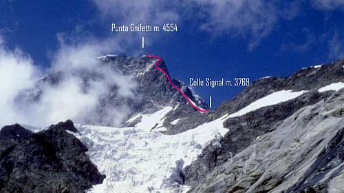
Ascent difference in level: 3054 m. from Cascata dell’Acqua Bianca, 2307 m. from Rif. Barba-Ferrero, 930 m. from Capanna Resegotti
Descent difference in level: 1300 m. from Punta Gnifetti to Punta Indren
Equipment: some pegs along the pitches
Exposure: E
First ascent: Harold W. Topham with Aloys Supersaxo and a porter 1887, july 28th
Huts and bivouacs: Rifugio Barba – Ferrero m. 2247, Capanna Resegotti m. 3624
Starting point: Alagna Valsesia m. 1186
Punta Gnifetti Cresta Signal
Cresta Signal is a long "course", running on the East boundary ridge of Punta Gnifetti, which separates the Valsesia side (SW) from the Macugnaga side (NE). A complex route, rising steeply from the Signal Col to the summit of Punta Gnifetti m. 4554. It involves a mixed climb and requires an excellent experience in high altitude and a good deal of insight to choose the best itinerary. Good conditions of the mountain and good weather forecast are required to climb this route in safety.
")
|

|

***Part I - Walking from Cascata dell’Acqua Bianca m. 1500 to Rifugio Barba-Ferrero m. 2247 Follow the steep path rising to the meadows named Alpe Fum Bitz m. 1603 , leaving on the left hand side the path to Rifugio Pastore. Continue on the right getting to Alpe Blatte m. 1635. At about 1860 meters cross a stream (huge block), then a second one, and rise towards the left edge of a great cliff, on which is lying Barba-Ferrero Hut. Leave on the left the trail to Capanna Gugliermina and follow the steep path on the right, getting to upper Alpe Vigne, a beautiful panoramic point over the southern side of Monte Rosa group and its wild summits. The approach walk requires about 2,30 hours from the parking near the fall.
***Part II - Scramble approach from Rifugio Barba – Ferrero m. 2247 to Capanna Luigina Resegotti on Punta Tre Amici summit ridge m. 3624 Capanna Resegotti is well visible from Barba-Ferrero shelter. Follow the trail starting behind Rif. Barba-Ferrero, heading to North and rising towards the impending moraine. Climb its steep and grassy side, then follow entirely its sharp edge to the upper limit at about 2700 m. of height. Continue inside a basin and leave it before its end, heading towards right and getting to the Locce Southern Glacier, at first easy and gently angled. Climb directly the glacier, becoming steeper, and leave on the left hand side the cliff named “Cavallo” (Horse), getting the upper limit of the glacier. There are two different options to reach Capanna Resegotti from the end of the glacier:
A - Head to left, cross the bergschrund and follow some fixed ropes leading directly to the bivouac, lying 800 meters East to Colle Signal. B – Alternatively head to right, then climb directly towards Punta Tre Amici summit ridge. From here follow the summit ridge towards left, leading to the bivouac.
The itinerary requires about 4 hours from Rif. Barba-Ferrero. Quite a long and strenuous walk - about 6-7 hours – is required if you climb directly to Capanna Resegotti from Cascate dell’Acqua Bianca, without spend the night at Barba-Ferrero.

|

|
***Part III - Climbing section from Capanna Luigina Resegotti m. 3624 to the summit of Punta Gnifetti m. 4554
The bivouac is the starting point of Signal ridge to Punta Gnifetti. From the bivouac follow the snowy ridge, crossing the two summits of Punta Tre Amici and getting to Colle Signal m. 3769 (one hour from Capanna Resegotti). Climb the ridge, mainly snow-covered, which is at first large and easier, then becoming sharp and leading to the first relief, consisting in a rounded pillar. It’s possible to skirt the pillar on the right or on the left, depending by the conditions. Right way: climb some huge blocks, then cross a scree, frequently snow-covered. Left way: follow a ledge, then climb a 20 meters high chimney, often icy, and get the main ridge again. Both the routes are getting to the summit of the rounded pillar. Now the ridge is becoming steeper and harder. After a small snowy shoulder, follow the main ridge, at first easier, then reaching a small wall, appearing quite difficult. From here cross a small gully on the right of the small wall, climb a great crack slanting right (III, IV-, 1 peg, 25 m.). Where the crack ends, climb up directly for about 60-70 meters on mixed terrain, skirting some huge blocks, leaving some pinnacles on the left hand side and getting to a sharp snowy “arête”. Follow it, leading to the bottom of the “Great upper relief”, a large and steep wall showing on the right a white vein “S”- shaped.
")
|

|
Follow the very obvious level ledge starting towards left and leading to the SE side for about one pitch, getting the middle of the ledge. Here climb up directly a small corner and huge blocks on the wall (III, IV-, 30 m.), gaining the main ridge on the summit of the Great upper relief. From here follow the obvious main ridge, amongst blocks and flakes (III, II) and a last snowy “arête”, getting the bottom of the huge summit tower, the Signal Pillar. Don’t climb it directly, but skirt it on the right, gaining the summit and Rifugio Margherita (6-7 hours from Capanna Resegotti).
Punta Gnifetti descent route description
***Part IV - The descent from Punta Gnifetti m. 4554 to Indren m. 3260 along the Normal Route
The descent is made following Punta Gnifetti normal route, quite a popular route almost always traced, running on the West side of the mountain. From the summit downclimb the steep but brief summit slopes facing NW, gaining the upper part of Grensgletscher, between Punta Gnifetti and Punta Zumstein. Turn to left (South), following the glacier for about 1 km., skirting Punta Parrot basal seracs and reaching the wide saddle named Colle del Lys m. 4248, between Eastern Lyskamm (on the right) and Ludwigshohe (on the left). From the col head to South along the Lys Glacier – pay attention to the crevasses – skirting Corno Nero and Piramide Vincent, getting at first to Rif. Gnifetti m. 3611, then to Rif. Mantova m. 3470. From Rif. Mantova the route crosses the Indren Glacier and leads to the upper station of Alagna - Punta Indren Cable car m. 3260. More information: Funivie Alagna Valsesia

|

|
Essential Gear
Rope, helmet, ice-axe, crampons, two ice-screws, a set of nuts, some ribbons, three-four quickdraws.
Red tape
No particulary restrictions in climbing. Private cars are not allowed on the route running from Alagna Valsesia to Cascata dell'Acqua Bianca.
Huts and Bivouacs
- Rifugio Barba-Ferrero m. 2240 – C.A.I. Vercelli, guarded only in full summer, 20 beds, cooking gears, a little room is always open when the hut is not guarded
- Capanna Luigina Resegotti m. 3624 - C.A.I. Varallo Sesia, 20 beds, not guarded, cooking gears
- Rifugio Margherita m. 3554 - C.A.I. Varallo Sesia, 70 beds
- Rifugio Giovanni Gnifetti m. 3647 - C.A.I. varallo Sesia, 270 beds,
- Rifugio Mantova m. 3470 - Società Guide di Gressoney, 90 beds

|

|

|

|
When to climb
Best period goes from July to September. It’s better to climb this route when the rocks, not always of good quality, are well covered by the snow, but otherwise many dangerous cornices can be found in early summer.
Meteo
METEO REGIONE VALLE D'AOSTA
METEO REGIONE PIEMONTE
METEOSWITZERLAND
Guidebooks and Maps
 |
 |
 |
 |
"Il grande libro dei 4000" by Marco Romelli, Valentino Cividini - Idea Montagna Editore, 2015
“Tutti i 4000 – L’aria sottile dell’alta quota” – Club 4000, CAI Torino – Vivalda Editori
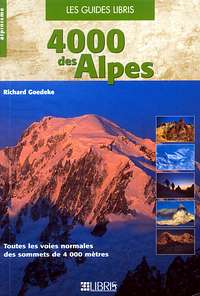
“4000 delle Alpi” by Richard Goedeke - Ed. Libris
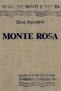
“Monte Rosa” by Gino Buscaini - Guida dei Monti d'Italia C.A.I.-T.C.I.
Carta Nazionale Svizzera, foglio 1348, Zermatt, scala 1:25.000
Carta Nazionale Svizzera, foglio 294, Gressoney, scala 1:50.000