
|
|
Route |
|---|---|
|
|
45.89050°N / 7.68430°E |
|
|
Most of a day |
|
|
BSA |
|
|
Approach
Follow "How get to Cheneil" in main page section
Route Description
Cheneil, ski-mountaineering
Perfectly assested snow required (see shots for more details):
- Rio Cheneil Waterfall gully (yellow line)
- Sub-valley over Lezan plateau (yellow line)
- Terminal slope (common yellow/orange line)
- Slope under SW side of Trecarè Peak (orange line)
- Traverse over a rocky belt (orange line)
Both trails are dangerous with incompatible snow condition! Take extremely care.
Suggested period: late March, early May. Spring is better. Avoid in winter!

Two possibilites for Monte Roisetta with skis
(Red ! = avalanches zones)
From parking there is a road on left side to get in Cheneil Basin. In Cheneil it takes to evaluate to pass from Rio Cheneil Waterfall gully (faster, shorter, yellow line in detailed shot), or heading to Col de la Croix and traverse under Trecarè, Petit & Grand Tournalin (longer, safer - not ever true! - orange line in detailed shot)
From "waterfall passage", yellow line. Cross whole Cheneil basin. Head to hard snow waterfall gully: keep, where possible, on right side. Crampons may help to pass the very steep jump.
Once passed waterfall, move on easy land. Reach Lezard plateau and turn right to a sub-valley. Be careful: avalaches are usual here.
Forward on same summer trail to reach summit. Final steep slope requires assested snow.
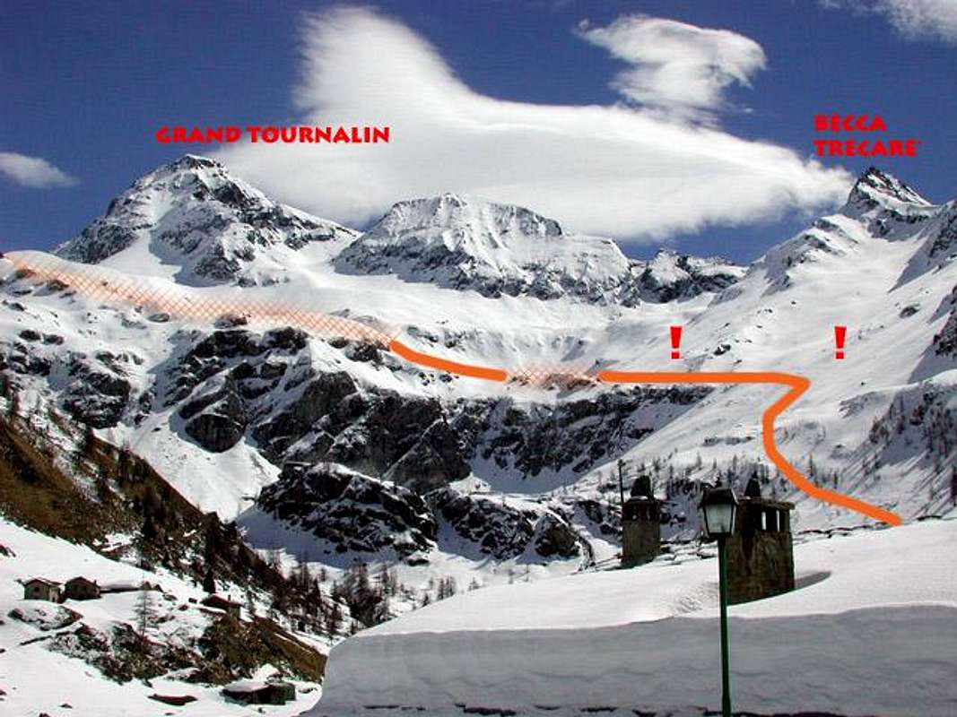
The begin of Great Traverse passage, seen from Cheneil village
(Red ! = avalanches zones)
From "great traverse passage", orange line. Head to Col de la Croix direction, then turn left to cross just over a big rocky belt. Very delicate passage at the beginning of this crossing. Forward half-a-way under Petit and Grand Tournalin, to reach a great plateau (about 2900 mt. o.s.l.), situated below final slope. Join here the trail over described for final steep slope.
Essential Gear
Alpin gear is required.
Miscellaneous Info
If you have information about this route that doesn't pertain to any of the other sections, please add it here.