
-
 22942 Hits
-
 86.77% Score
-
 23 Votes
|
|
Mountain/Rock |
|---|---|
|
|
37.64310°N / 107.6291°W |
|
|
San Juan |
|
|
Hiking, Mountaineering, Trad Climbing, Toprope, Ice Climbing, Mixed, Scrambling |
|
|
Summer |
|
|
13786 ft / 4202 m |
|
|
San Juan Range Overview
The San Juan Range is the largest mountain range in Colorado. It dominates southwestern Colorado. In Colorado, the San Juans are second in snowfall only to the Park Range. The San Juan Range is home to 357 peaks above thirteen thousand feet.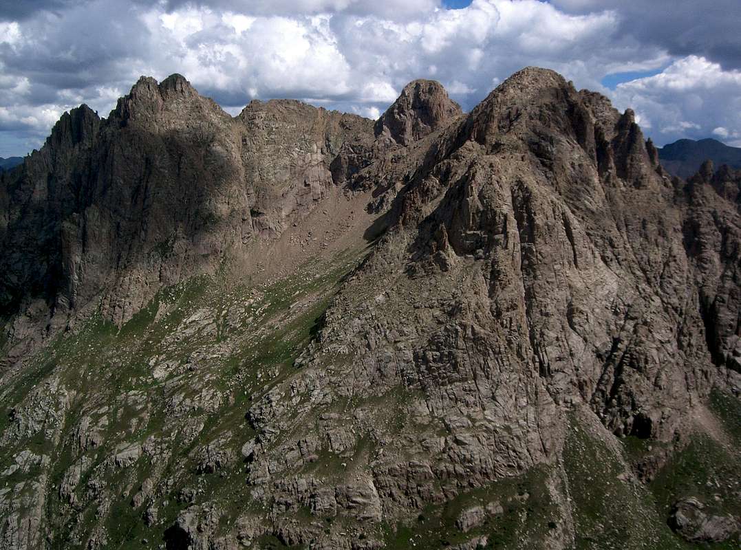
Animas Mountain, Peak Thirteen & Monitor Peak, from left to right, from Peak Sixteen
Animas Mountain Overview
Animas Mountain lies 1.2 miles northeast of centennial thirteener Pigeon Peak on the north side of Ruby Creek deep in the Weminuche Wilderness. Animas is the 59th highest thirteener in Colorado, 112th highest peak in the state of Colorado and the 143rd highest peak in the contiguous United States. Animas Mountain was first climbed on July 20, 1934 by Everett Long, John Nelson and Carleton Long (1). Their route is now the standard southeast face route described below and is considered a third class scramble (2). A technical snow and rock route on the north face is another viable route (2,3).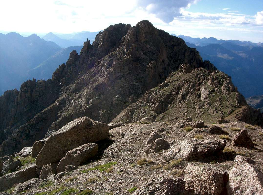
Animas Mountain from Peak Thirteen
Getting There
The Needleton Trailhead is most commonly reached by the Durango Silverton Narrow Gauge Railroad. Roundtrip tickets cost $65 as of 2007. Avoiding the train requires an additional 1612 feet of elevation gain and 19 miles of hiking from the Purgatory Trailhead (4).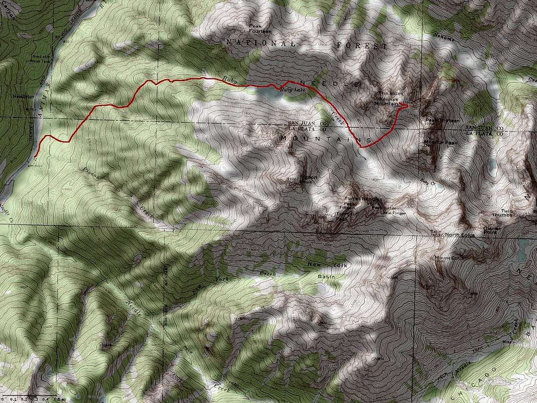
Animas Mountain’s southeast face route. Click to enlarge.
From Needleton, hike 260 yards north on the Animas River Trail, cross Pigeon Creek and hike an additional 0.2 miles to a meadow at 8,260 feet. Hike north looking for a fallen tree. Look for a trail heading east of the tree. This is the Ruby Creek Trail. Follow the Ruby Creek Trail to a small ridge at 9,800 feet. Continue following the Ruby Creek Trail 0.4 miles to another ridge at 10,340 feet. There is a small campsite here. Continue another 0.1 miles east. After descending a steep step in the trail, the Ruby Creek Trail forks for 0.2 miles to avoid cliffs. The upper fork is recommended. After the trails rejoin, continue another 0.7 miles east to a small lake west of Ruby Lake. Cross to Ruby Creek’s north side, follow the Ruby Creek Trail to Ruby Lake and continue hiking along its north side. Immediately after passing Ruby Lake, look for the continuation of the Ruby Creek Trail to the left climbing northeast. Follow the trail to the large meadow east of Ruby Lake at 11,600 feet. This is a great campsite for climbs of Pigeon Peak, Turret Peak, Animas Mountain, Peak Thirteen, Peak Fifteen, Monitor Peak and Peak Sixteen. From 11,600 feet, climb northeast to 12,600 feet. Ascend a steep and loose gully to 12,900 feet. Traverse east and climb to the 13,500 foot Animas Mountain-13620 saddle. Climb northwest until blocked by a cliff band. Traverse right into a broad gully and climb it. Exit the gully on its right side on ledges. Follow the ridge to the summit. Approaching the 13,500 foot saddle is very steep and loose and perhaps best used only as a descent. Climbing Monitor Peak and Peak Thirteen prior to Animas Mountain avoids ascending this steep and loose gully (5).
Red Tape
Animas Mountain is in the Weminuche Willderness; mechanized travel is forbidden.Camping
There are good campsites at 8,260 feet at the junction of the Animas River and Ruby Creek Trails, at 10,340 feet on the Ruby Creek Trail, at the lake west of Ruby Lake and at 11,600 feet in Ruby Creek.External Links
Lists of John14ers.com TR featuring climbs of The Index & Little Finger
References
1. Trail and Timberline, February 1935.2. San Juan Mountains
3. Trail and Timberline, October 1960.
4. Colorado's Thirteeners: 13,800 to 13,999 Feet, From Hikes to Climbs
5. Colorado's High Thirteeners: A Climbing & Hiking Guide