
-
 5762 Hits
-
 83.69% Score
-
 17 Votes
|
|
Route |
|---|---|
|
|
46.22045°N / 10.66347°E |
|
|
Mountaineering |
|
|
Summer |
|
|
Most of a day |
|
|
F - Alpine Scale |
|
|
Overview
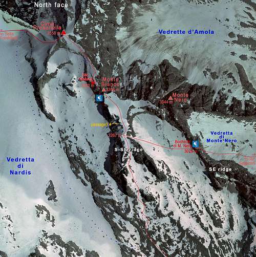
Presanella SE Normal Route across Monte Nero
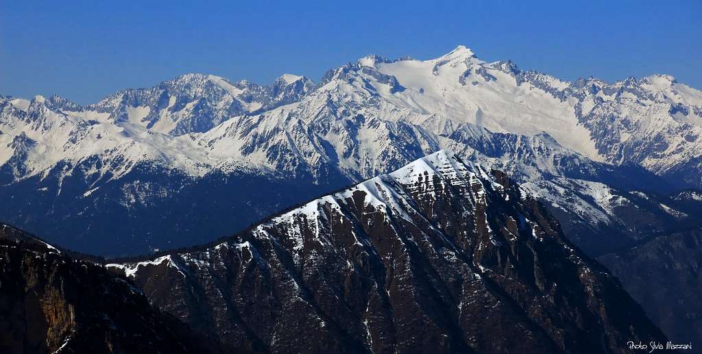
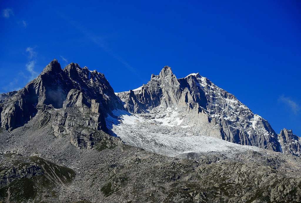
Cima Presanella 3558 m is a superb snow-capped mountain in shape of pyramid, very admired in reason of its fascinating appearance. It's the highest mountain among those ones entirely located in the Trentino region and for this reason as well as for its beauty it is frequently climbed. The most attended routes to reach the top are the three Normal routes, but also some more demanding routes, as the North wall, are frequently climbed. Presanella shows three sides, a steep Northern side, facing the Val Stavel, a triangular rocky wall facing East towards the Val d'Amola and a third flank facing South and showing more gentle slopes, partially covered with glaciers slanting down to the Val di Genova, Val di Nardis and Val Nambrone.
From Val Nambrone it starts the most popular climb amongst the easy routes: the Normal Route from the South-East across Monte Nero, a varied, never boring and somewhere a bit delicate itinerary, allowing you to reach the beautiful summit of this mountain, 3558 m. the highest one in Trentino and also within the whole mountain range to which it belongs, the Adamello-Presanella. Wrongly considered as a simple walk, actually this route always keeps its alpine feature, although the most challenging passages through Monte Nero are now equipped with steel cables making easier the passage. It's also required a good physical endurance, given the length and the difference in level of the route, about 1200 meters from Rifugio Giovanni Segantini.

|

|
The superb summit of the Presanella offers a magnificent panorama towards the nearby Adamello and the most distant Ortles-Cevedale and Bernina groups, as well as the Brenta Dolomites.
Getting There
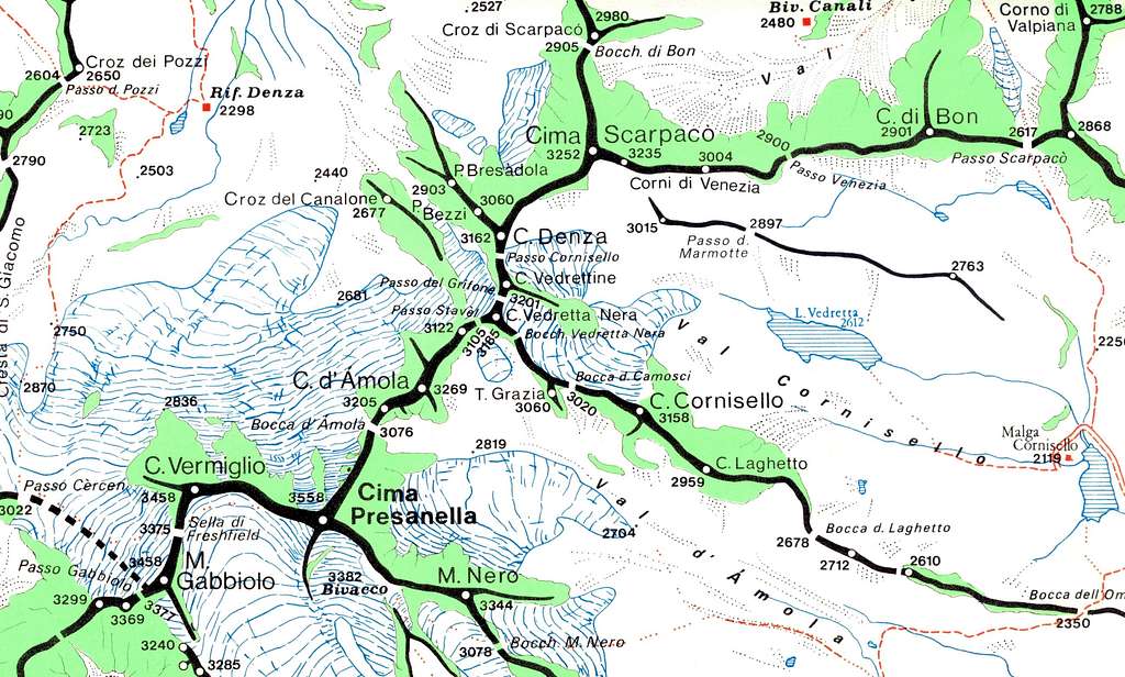
Route's map - Courtesy of Vid Pogachnik
Road access
The road acces is from Val Rendena.
Coming from Autobrennero motorway exit Trento and take the road to Riva del Garda, reaching Le Sarche. Here continue straight toward Tione di Trento. In Tione turn to right and take the SS 239 Val Rendena route to Pinzolo. Pass Pinzolo and drive a few kilometers towards Madonna di Campiglio. After the village of Carisolo, leave the main road and turn to left, taking a narrow road rising along Val Nambrone towards Laghi di Cornisello. After driving about 9 km on this road with several hairpins we reach a fork. The main road leads to Laghi di Cornisello, we turn to left (Rif. Segantini signposts), ignore the path n. 211 on our right hand side and continue driving for about 1 km, parking at the bridge over the river Sarca ahead Vallina d’Amola alp (2008 m.).
Approach to Rifugio Segantini
Park the car near the Malga Vallina d'Amola and walk along a small gravel road towards the alm. After this, the road becomes a path marked with the 211 trail marker. After crossing a stream, the path climbs up a slope on the right with steep hairpin bends. Once you reach the top you start to see the refuge and also the summit of the Presanella. Going westward along the ridge with a moderate slope, you will soon reach the Rifugio Segantini 2373 m (about an hour from the parking lot).
Route Description
Presanella Normal Route from Refuge Segantini across M. Nero description
Difficulty: F (Alpine scale)
Difference in level: 1185 m from Rifugio Giovanni Segantini
Starting point: Malga Vallina d’Amola 2008 m
A worthwhile and varied route up the highest peak entirely located in the Trentino region. The ascent doesn't oppose particular technical difficulties, being the most challenging section across Monte Nero equipped with fixed iron rope.
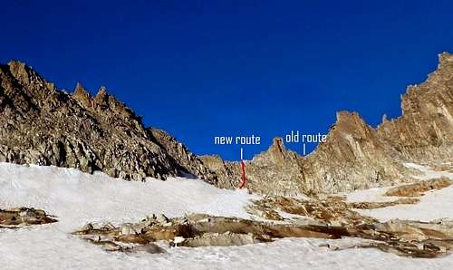
New route and old route across Monte Nero
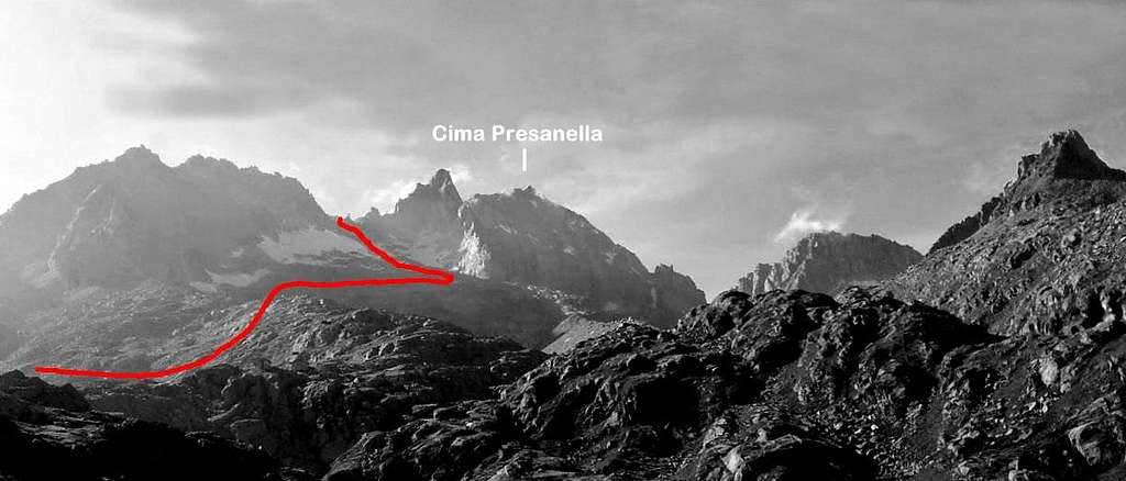
Just behind the Rifugio Segantini take a well-worn path heading to North-West, initially marked with white-red marks, then with cairns, and signposted “Presanella”. The trail rises to the large and prominent moraine lying in the middle of the valley, between the small Vedretta di Monte Nero and the Vedretta d’Amola. "Vedretta" is the local name meaning “small glacier”. The trail runs along the moraine, then across the rocks below the Vedretta of Monte Nero.

|

|
After crossing the small glacier, often icy, the Via Ferrata starts, keeping to the South of Bocchetta di Monte Nero across a new passage lying on the left of the old route. The Via Ferrata allows to climb up the rocky band and overcome it, reaching the ridge at about 3170 m. From here the route downclimbs to the opposite side getting the Vedretta Orientale di Nardis. Once gained the Vedretta di Nardis, characterized by huge granite boulders, we proceed heading to North-West keeping Monte Nero on our right hand side.

|

|

|
Getting the head of the valley the route begins to climb steeply to reach the summit plateau and the Bivacco Orobica 3382 m. (a short equipped section). From the bivouac the summit is clearly visible and we reach it along the snowy summit ridge. Summit cross and summit book, wide exciting panorama.
Descent: reversing the route

|

|
Hut
- Rif Segantini 2371 m.
Situation: Val d'Amola
Open: 20 of June - 20 of September
Size: 54 pers
Winter shelter: yes
Owner: S.A.T. (Società Alpinisti Tridentini)
Guardian: G.A. Egidio Bonapace
Hut's phone : 0039-0465-507357 Hut's reservation phone : 0039-465-440539 Mobile +39 336 683500
Getting There: from Val Nambrone and Malga Vallina d'Amola m. 2020 (1 hour)

|

|
Approach to Rifugio Giovanni Segantini
From the parking lot continue walking along the road and ahead Malga Vallina d‘Amola take on the right the path 211 to Rifugio Segantini, reaching a bridge on a stream at 2052 meters, just above the "malga". Crossed the bridge, the trail forks: take the path 211 named “Oscar Collini”, getting to Rifugio Segantini m. 2373 (1 hour from the parking lot).
Essential Gear
Rope, axe, crampons and Via Ferrata set.
Red Tape

No fees no permits required. Presanella is situated within Adamello-Brenta Natural Park , the largest protected area in Trentino, established in the year 1967. It's located in Western Trentino and with its 620.51 square kilometers includes the mountain groups of Adamello, Presanella and Brenta Dolomites, separated by Val Rendena.
When to climb
Mountaineering: best months are June, July, August and September.
Ski-mountaineering: from the end of March to the beginning of May
Meteo
Guidebooks and maps

"Presanella" - Guida dei Monti d'Italia CAI-TCI - Dante Ongari
Maps
Dolomiti di Brenta, Adamello, Presanella - Tabacco Foglio 10 scala 1:50000