
-
 133237 Hits
-
 95.13% Score
-
 51 Votes
|
|
Mountain/Rock |
|---|---|
|
|
39.85220°N / 105.6894°W |
|
|
Hiking, Mountaineering |
|
|
Spring, Summer, Fall, Winter |
|
|
13294 ft / 4052 m |
|
|
Under New Ownership
This page was transferred to me when the original owner left Summit Post. Some of the text below was written by member "Peakwolf" and I am happy to keep this page up to date.
Overview
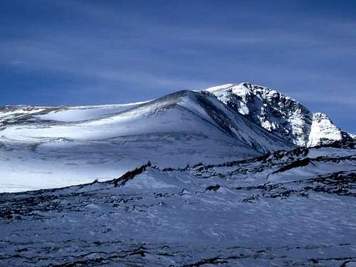
At 13,294 feet James Peak is the 5th highest summit in the Indian Peaks. It is also the Gilpin County highpoint. Its giant southeast slopes route can be seen from I-70 as you head towards Idaho Springs. According to Walter Borneman in his book Colorado's Other Mountains the peak was named after Edwin James, a highly respected botanist who was part of an 1820 expedition to the Rocky Mountains. James became a mountaineer and was the first person to do a recorded ascent of a Colorado Fourteener. Ironically it did not end up being named James but was called Pikes Peak instead. James is a peak of many options, with easy walks, a technical east face and an interesting ridge walk from neighboring Mount Bancroft. It is an extremely popular peak and is a common first ascent for those who are interested in ski mountaineering. James Peak and vicinity has recently been made into a Wilderness Area.
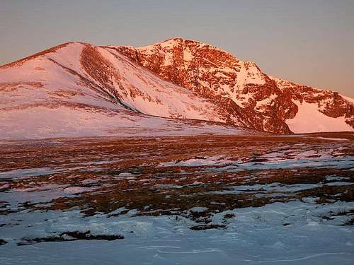 Sunrise over James Peak Sunrise over James Peak |
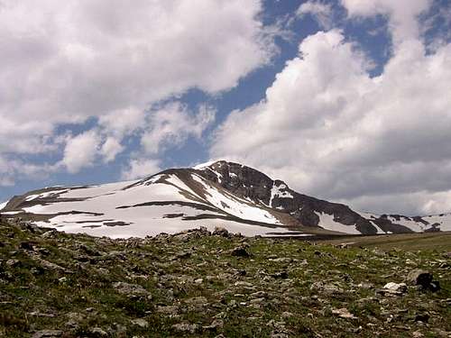 James Peak seen from above St. Marys Glacier James Peak seen from above St. Marys Glacier |
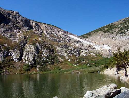 St. Marys Glacier in September St. Marys Glacier in September |
Getting There
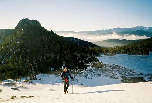
There are several ways to access James Peak. To reach the Southeast slopes/St. Mary's Glacier route drive on I-70 west out of Denver and just west of Idaho Springs, take the Fall River Road/St. Mary's Glacier turnoff with signs for St. Mary's/Alice. Drive north on the Fall River Road for approximately ten miles and reach the St. Mary's trailhead located on the left side of the road at 10,400 feet. The correct parking area is just west of Lake Quivira and has enough room for 20-25 cars. Do not park at the larger parking area at the base of some ski runs a quarter mile before the actual trailhead. Unfortunately, there is a $5 fee to park here as it's on private property and they do enforce this. In May 2011 when I did James Peak, we didn't pay and the land owners put a note on out window asking us to pay. From the trailhead follow a wide and well groomed trail/road towards St. Mary's Glacier. Upon reaching any forks, head left/up rather than down. In about a half mile you will come to St. Mary's Lake and see the "glacier" which is a tongue of snow terminating at the lake. Note that this is no longer a glacier and hasn't been for nearly 25 years. The left side of the snowfield is steep and should be avoided when avalanche conditions are moderate to high. Ascend the snowfield on the less steep right side until you top out on a huge flat expanse of tundra. At this point you will see James directly in front of you.
 Saint Mary's Glacier and Lake from the "glacier"
Standard Route - Southeast Slopes Class 2
Also see the SE Slopes Route page for more information.
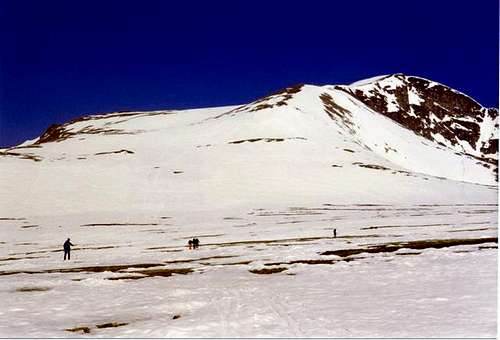
As you continue west towards the peak make note of a huge rock outcropping on your left. This is a good place to take a break and a good landmark if the visibility gets bad. This rock pile is your gateway back to the glacier. Continue to the base of the peak which is an easy tundra hike/boulder hop. The ski route is directly up the huge SE face. If you are climbing or if the avalanche danger is high, you might want to stay on the SE ridge to your right. The final 1200 feet may seem long but you will arrive at the summit which appears abruptly. The final summit "pyramid" is probably around 35 degrees and can be dangerous in unstable snow conditions. In this case even skiers might want to forgo that section and hike the ridge to the summit. Take a look down some of the couloirs on the steep east face. Enjoy the spectacular views from the big flat summit. Besides the few hundred feet just below the summit, the rest of the route down is quite moderate and a blast in good corn snow. On the way down be sure not to stray too far right into the drainage leading to Loch Lomand. Also important, if the weather looks like it could white out, be very religious about using your compass/GPS. The huge tundra plain can be extremely disorienting in a white out and there are many routes that will lead you to other drainages. Use the big rock pile as your guide! This route is 7 miles round-trip and 2920 feet of elevation gain.
 View of James from the tundra flats View of James from the tundra flats |
 At the top of the St. Mary's glacier At the top of the St. Mary's glacier |
 SE Slopes Route - Slope never exceeds 30 degrees SE Slopes Route - Slope never exceeds 30 degrees |
Map
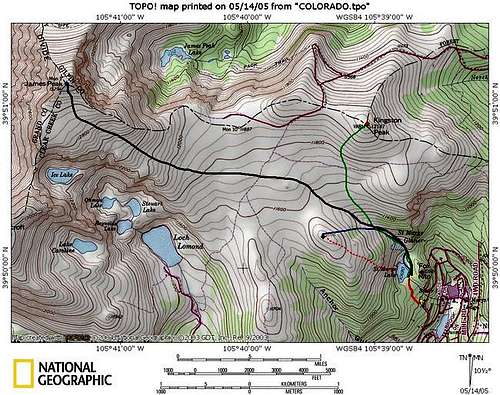
This map shows the Saint Mary's Glacier area and shows the various routes described on this page.
The black line represents the standard southeast slopes route up James Peak
The bold red line shows the approach to St. Mary's Lake
The dashed red line represents the climb up the central gully (not typically used)
The green line represents the route up Kingston Peak
The dashed yellow line represents the route up Fox Mountain
Other Access Points
West Side
Another access is from the west side and Rogers Pass. Go west on I-70 to mile marker 232 and take highway 40 over Berthoud Pass. Continue on to Winter Park. Look for a road, on the right just beyond the Winter Park entrance. Locate a sign for Corona Pass, Moffat Road, County Road 80/ FDR 149. Continue on 149 through several intersections. Along this road are many beautiful views of the Winter Park ski area. About 9 miles up the road you will see an old train trestle, stay on the road until you get to the top of the trestle, there is space for a few cars near the trestle. The trailhead to Rogers Pass and James Peak starts here. It's an old jeep trail with barricades in front (boulders and posts). From here the trail rises gently out of the tree line to about four switchbacks that take you to the top of a ridge and around a bend for you first look at James Peak. The trail continues to a split. The left trail takes you to Rogers Pass. Rogers took a load of wagons from the east over here in 1868, before Berthoud Pass was constructed. The right trail takes you to James Peak on a somewhat easy hike to the base of the peak. Then it gets tougher when you get into the boulders however the view on top is well worth the few 100 yards of boulder hoping. This route is 3.5 miles one way. Note that for those coming from Boulder, Rogers Pass can be accessed via the East Portal of the Moffat Tunnel (from Rollinsville). From the tunnel head towards Heart Lake and past the lake upwards to Rogers Pass. Its about a 4 mile hike to Roger's Pass and then another 2 miles ridge walk to the summit, but its a shorter drive.
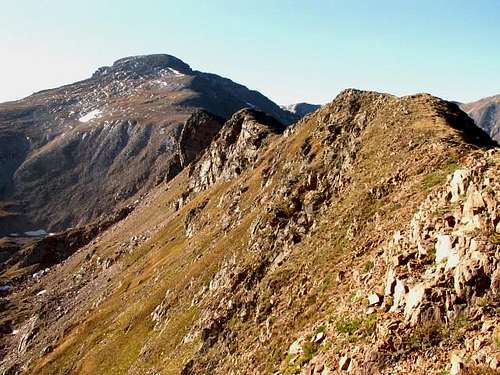
 West Face of James Peak
East Side
To reach the east side climbing routes use the Upper Mammoth Gulch trailhead. All of these routes are as described in Gerry Roach's excellent guide Colorado's Indian Peaks. The road is 4WD and can be blocked partway up by snow into June. From Denver, drive on Colorado 119 north to Rollinsville. You can also drive from Boulder to Nederland and then drive south on 119 to reach Rollinsville. Turn west onto a well maintained gravel road, heading towards the East Portal of the Moffat Tunnel. Go 5 miles west to the little town of Tolland, then go just another 0.2 miles to a left turn at Mammoth Gulch Road. Drive 4 miles to another junction (old townsite) and turn west . Continue approximately 3 miles west to the end, which is a steep north facing slope. From here it is possible to access the south east slopes. This might be a good idea if the parking situation doesn't improve. From this trailhead head south up an old 4WD road to 12,000 feet. This is the shoulder west of Kingston Peak. Head west and descend to meet the southeast route on the huge tundra plain. To reach the other east side routes, head west on the Ute trail to a junction at 11,150 feet. At this junction still head west to James Peak Lake. At this point you can access all of the east face routes described in Roach's book-Northeast slopes (class 2 hiking), Starbright, Super Star, Shooting Star (see ROUTES section of this page), Sky Pilot and Starlight couloirs. If anyone has been up any of these, please feel free to post the routes! I do know that the Starlight couloir is often skied. The couloir starts out at about 40 degrees but soon widens and the angle gets less steep. If you take a look from the top and decide its too much for you, you can try the "Bailout" route just south of the couloir. These ski routes (as well as the standard southeast slopes route) are described in the must-have (if you want to ski in the Indian Peaks) book by Ron Haddad and Eileen Faughey Indian Peak Descents.
 East face of James Peak
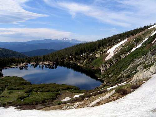
For a climb/ski on the north side of James Peak, drive to the East Portal trailhead out of Rollinsville then follow the Heart Lake trail to Heart Lake. From there you can use the map to find the best route to the base of James's north face. It looks like you shoot for Rogers Pass lake, then go around the east side of Haystack Mountain. This looks like an awesome descent, but a very long day.
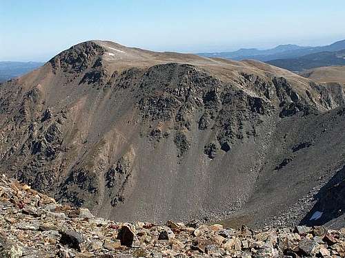
![James Peak, north ridge.]() James Peak north ridge
James Peak north ridge
![St. Mary's Glacier makes an...]() Test your 4 season tent here!
Test your 4 season tent here!
According to Haliku in February 2004: I have been to St. Mary's several times in the last six months to hike and break in equipment. The first lot on the left before the trailhead is blocked by rocks and posted. This is where everyone parked in the 90s. Go past the trailhead 200 feet to a narrow lot on the left side. Parking is limited due to the size and often how everyone parks. It can hold 20-25 vehicles. The road berm in the area is heavily and clearly posted and I can only guess patrolled and violators ticketed on the weekends when it is most busy. Arrive early if you want parking, especially on a weekend.
 James Peak north ridge
When to Climb
The standard southeast route on James Peak can be pretty much climbed year round, though be ready for extreme wind and cold in the winter. The couloirs are best done in spring and early summer, depending on the previous years' snowpack. Most of them melt out by August. The best time to ski the southeast slopes is probably in late April to early June. In the late spring and summer be prepared to bail out in case of lightning storms. Most of these routes are above treeline and there is no safe place to wait in case of lightning. The lightning in Colorado is a serious threat and one should have a healthy respect for the danger, every year people are killed by storms in Colorado.
Camping/Red Tape
There is a $5 fee to park at the trailhead for the standard SE slopes route. The peak itself lies in a wilderness area so no motorized vehicles or bikes are allowed. Camping doesn't make much sense in this area due to the large amounts of private property nearby and the short nature of the routes. Do this peak as a day climb however there is an established camping area called the Idlewild camp ground along Highway 40 near Winter Park.
St. Mary's Glacier however makes an awesome place to test new gear or practice your self arrest skills. Many Colorado mountaineers come here to get hands on practice for self arrest, crevasse rescue and snow climbing experience before embarking on climbs in the Pacific Northwest.
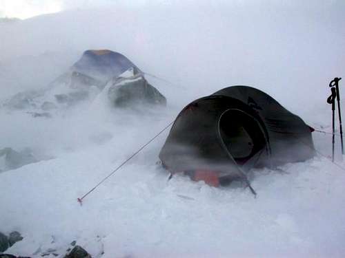 Test your 4 season tent here!
JacLMill - Jun 3, 2010 5:46 pm - Hasn't voted
ParkingThere is no free parking anywhere near St. Mary's Glacier, only $5 parking on private property with limited space. There are no parking and no trespassing signs on nearly every tree up there. The forest service needs a little pressure from us citizens to get their act together and provide legal parking for their tax paying citizens.
glacierpaul - Jul 31, 2011 7:13 am - Hasn't voted
legal parkingAs of July 22, 2011, (besides the small pay lot) I have opened up the old ski area parking lot for more (legal) pay parking. The forest service will not provide all I am providing with my properties or just parking for that matter. St. Mary's is a private sub-division, which has public access thru private property, however, the glacier hike itself is mostly private property as well. As of now there no plans to stop the use, in fact I have insured this. On a side, if the USFS did what I am doing with my property, they would be charging or concessionaire it out. I provide 4 porta-potties(2 at each lot), trash/recycle cans, dog waste bags, and a year round maintained legal parking area for all visitors, and I now have plenty of space. It is $5 per vehicle, per day. Hope this helps, pm me if needed. Thanks, Paul