Toggle navigation
Mountains
Routes
Images
Trip Reports
Forum
What's New
People
Areas & Ranges
Articles
Trailheads
Canyons
Huts & Campgrounds
Albums
Logistical Centers
Fact Sheets
Lists
Custom Objects
Gear
Plans & Partners
WELCOME TO SUMMITPOST
SIGN IN
REGISTER
Austera Peak
Additional Parents
Image
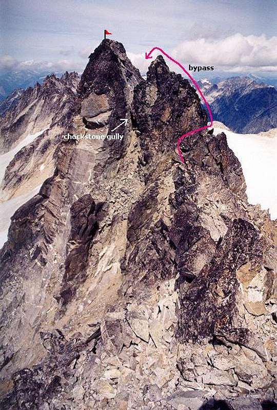
The summit tower from the...
View High-Resolution Image
The summit tower from the...
The summit tower from the summit ridge. Pink line refers to Class 3/4 bypass, which is markedly easier than the Class 5 chockstone gully. Compare with the winter scene
here
. Aug. 20, 2004.
« PREV
NEXT »
Klenke
on
Aug 24, 2004 11:03 pm
Comments & voting
Other parents
Lat/Lon:
48.56930°N / 121.1021°W
Image ID:
66718
5772 Hits
74.01
% Score
4
Votes
Log in to vote
Comments
No comments posted yet.
to post!
Don't have an account?
Austera Peak
(Mountain/Rock)
« PREV
Viewing
#23 of 35
GALLERY
NEXT »
Klenke's Image Gallery
« PREV
Viewing
#1555 of 5376
GALLERY
NEXT »
×
You need to login in order to vote!
User Name
Password
Remember me
Forgot your password?
Log me out when I close my browser.
Keep me logged in all the time.
sign in as a user
Don't have an account?
Register now for FREE
Rating available
Suggested routes for you
People who climb the same things as you
Comments Available
Create Albums
Register Here


