
|
|
Mountain/Rock |
|---|---|
|
|
37.68954°N / 119.19999°W |
|
|
13143 ft / 4006 m |
|
|
Overview
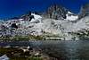
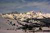
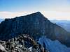
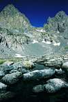
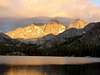
Mt. Ritter is the highest peak in the Ritter Range, a volcanic ridge west of the Sierra Crest, just outside Yosemite's southeast boundary. The Minarets, a set of more than a dozen fantastically sharp pinnacles in this range, together with Mt. Ritter and Banner Peak make for a striking skyline when viewed from the Mammoth Lakes area. According to Secor, "Mount Ritter is perhaps the most prominent peak in the High Sierra, and can even be seen from certain summits in the southern portion of the range." It is easily recognizeable (in conjunction with its neighbor Banner Peak) from as far north as the peaks around Sonora Pass, and far into the southern parts of the range, from the Palisades to Mt. Goddard, and some points even further. For highpoint seekers, Mt. Ritter is also the highpoint of Madera County, one of the more arduous of the 58 county highpoints in California. Mt. Ritter is a popular climb, primarily approached via Agnew Meadow. It can be climbed as a dayhike, but is most often done as a multi-day outing into the surrounding Ansel Adams Wilderness. Alan Ritter's 7 attempts to climb his namesake have become almost legend in climbing circles.
 |
 |
 |
 |
 |
Getting There
From US395, take SR203 into Mammoth Lakes. Follow the highway (turn right at the second light) to the main lodge of Mammoth Mountain. If you are there before 7am or after 7pm, you can continue past the ski resort, driving over Minaret Summit and down towards Devils Postpile. During the daylight hours above, all visitors must pay a $7/person fee, and use the mandatory shuttle bus. Cyclists can enter on their own without paying the fee, but will be charged if they use the shuttle bus on the way out. See the Red Tape section below. Agnew Meadows is the first campground on the right, just as the road begins to turn south. Drive past the pack station to one of two parking lots on the left side of the graded dirt road.
 |
 |
 |
 |
Red Tape
Lots of Red Tape. SR203 west of the Minaret Summit(designated "Reds Meadow Valley") has travel restrictions due to the narrow one-lane road (in many sections) and the limited parking available at the popular national monument. Travel by car into the area is unrestricted before 7am and after 7pm, so try to plan your trip accordingly. Between these hours it is required that you take the shuttle bus which leaves every 30 minutes, and more frequently during periods of high use (buses will accommodate backpacks). If you want to do a loop starting at Agnew and returning to Devils Postpile, you can ride the shuttle for free back to Agnew Meadows. Once your vehicle is in the area, you are free to exit anytime of day, but you will be subject to a $10 per-vehicle charge if you haven't previously paid the fee and the entrance station is manned. Backpackers with permits do not have an exemption from using the shuttle during normal daytime hours. Entry fee into Reds Meadow Valley is $7 per person, which allows free use of the shuttle. A federal Interagency (NPS and USFS) pass can be used for the shuttle or vehicle fee. Fees collected are used to pay for and encourage the use of the shuttle bus. Everything you need to know about permits and regulations can be found on the Eastern Sierra - Logisitcal Center page. On the more popular trails (Thousand Island Lake, Shadow Lake, Minaret Lake, etc.) camp fires are not permitted and camping is restricted to designated areas. On popular summer weekends the quota for permits may run out, so advance reservation is advised (fee apply).
When To Climb
Mt. Ritter can be climbed generally only as long as Highway 203 remains open west of the Sierra Crest. The road is closed during winter months due to the high danger of avalanche on the upper section of the highway. The road usually opens around Memorial Day, and closes sometime in mid-October. Call the Ranger Station for closure information if you plan a trip near either of these times. Climbing during other times in the year can still be done, but will require a longer trek starting near the Mammoth Mtn main ski lodge.
Camping
Camping is allowed in most places in the Ansel Adams Wilderness. There are special restrictions in the area between Shadow Lake and Ediza Lake, designed to reduce impact in these highly used areas. You can get information on these restrictions at the Ranger Station when you pick up your permit, and there are maps posted along the trail showing the restricted areas. The best (and closest) camping is probably on the northwest side of Ediza Lake. Camping at Agnew Meadows is available for $16 per site for those looking for more than Wilderness amenities. Contact the Forest Service for advanced reservations.
 |
 |
Mountan Conditions
The Mammoth Lakes Visitor Center & Ranger Station can provide the latest information on trail and climbing conditions.
 |
Etymology
"The Mountain was named by the Whitney Survey in 1864. 'Ritter is the name of the great German geographer, the founder of the science of modern comparative geography.' (Whitney, Yosemite Guide-Book, 1870, 101.) Karl Ritter (1779-1859) was a professor of history at the University of Berlin when Whitney was a student there during the 1840s. John Muir made the first ascent in October 1872. 'I was suddenly brought to a dead stop, with arms outspread, clinging close to the face of the rock, unable to move hand or foot either up or down. My doom appeared fixed. I must fall. There would be a moment of bewilderment, and then a lifeless rumble down the one general precipice to the glacier below. When this final danger flashed upon me, I became nerve-shaken for the first time since setting foot on the mountain, and my mind seemed to fill with a stifling smoke. But ... life blazed forth again with preternatural clearness. I seemed suddenly to become possessed of a new sense. ... Then my trembling muscles became firm again, every rift and flaw in the rock was seen as through a microscope, and my limbs moved with a positiveness and precision with which I seemed to have nothing at all to do. Had I been borne aloft upon wings, my deliverance could not have been more complete. ... I found a way without effort, and soon stood upon the topmost crag in the blessed light.' (Muir, Mountains, 64-65.) The mountain is named on Hoffmann and Gardiner's map, 1863-67. 'Ritter Range' appears on the fifth edition of the Mt. Lyell 30' map, 1922. Neither the lakes nor the pass are named on the 15-minute quad. There are four lakes, two large and two small, west of Mt. Ritter and south of Lake Catherine. The pass is over the range 1.2 miles south-southeast of Mt. Ritter." - Peter Browning, Place Names of the Sierra Nevada "From their base camp on Illilouette Creek they [Clarence King and James Gardiner] explored further among the Merced Peaks, then crossed to the San Joaquin and followed up the North Fork of the river. They made an attempt to climb Mount Ritter, but failed on account of unfavorable weather. King said that he 'climbed to a point about as high as Mt. Dana, and had still above him an inaccessible peak some 400 or 500 feet high.' Inaccessible, again! Whitney records that 'Messrs. King and Gardner discovered a bed of ice on the east slope of Mount Ritter. But it is doubtful,' he adds, 'whether these residual masses of ice can with propriety be called glaciers; they have no geological significance as such at the present time, however interesting they may be as possible relics of a once general glaciation of the highest part of the range.' Thus both the ascent of Mount Ritter and the identification of glaciers had to wait for John Muir." - Francis P. Farquhar, History of the Sierra Nevada [In 1892] Solomons and Peixotto teamed up with [Joseph N.] LeConte for an excursion south toward Mount Ritter, that dark beacon that looms immediately southeast of the present Yosemite National Park boundary. Following in the footsteps of John Muir, the three youths climbed the peak from the east; it was only the third time its 13,157-foot summit had been reached. Pleased with this conquest, the trio returned to Yosemite Valley." - Steve Roper, Sierra High Route John Muir's account of the first ascent: Chapter 4 from The Mountains of California (This is the full text of Muir's climb of Mt. Ritter)
External Links
- Morgan's trip report Lame, rambling prose on our August 25, 2001 climb of Ritter's SE glacier.
- Mt. Ritter Climb, September 2001 Trip report and photos of climb up SE Glacier route, 9/01
- Mt. Ritter Climb, June 2001 Trip report and photos from Mt. Ritter climb via Clyde Variation, SE Glacier route, June 2001
- A dayhike - Oct 10, 1998