
-
 39910 Hits
-
 93.15% Score
-
 42 Votes
|
|
Mountain/Rock |
|---|---|
|
|
46.27027°N / 9.75037°E |
|
|
Mountaineering, Trad Climbing, Ice Climbing, Mixed |
|
|
Summer |
|
|
12066 ft / 3678 m |
|
|
History
Monte Disgrazia
What's New on this Page?
* Jan 6, 2023 - Ownership switched by Antonio Giani
* Jan 6, 2023 - Page under review
* Jan 8, 2023 - Overhaul of the page
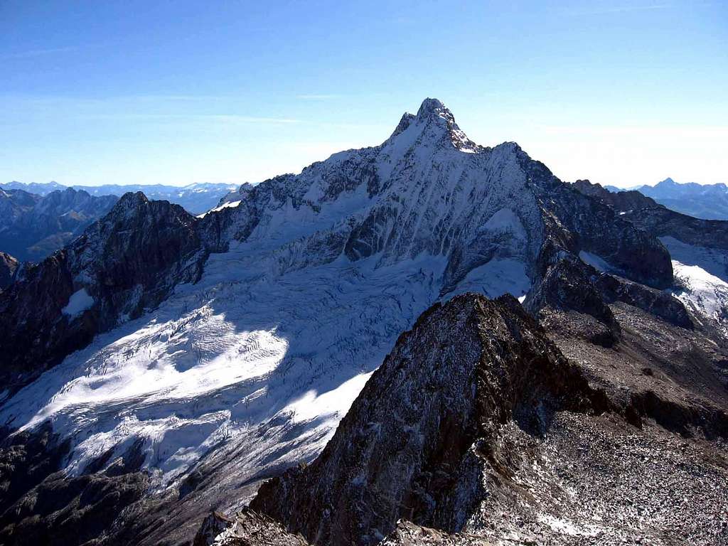
Monte Disgrazia is a 3678 m high mountain in the Western Rhaetian Alps. Belonging to the province of Sondrio, riding between Val Masino and Val Malenco and located entirely in Italian territory, it is one of the main peaks of central Valtellina. It is the highest mountain of the region Masino-Bregaglia-Disgrazia, situated in the namesake Disgrazia Group, south of the Bernina Group. Five glaciers and five wild ridges form one of the most impressive mountains of the Alps that shows equal beauty from all sides. Climbing Monte Disgrazia is an ambitious trip, C and experiences in climbing. The route of the first summiters over Preda Rossa glacier and the North-West ridge is the easiest one and is considered the Normal route. It is a route of satisfaction, a mixed “course”, alternating snowy ridges and easy rocky steps. that alternates rock and ice. It does not present great technical difficulties, however it takes place on an exposed ridge and requires enduranmce and mountaineering experience. In ancient times "Monte Disgrazia" was called "Pizzo Bello" (Beautiful Peak), name which would have been better suited to define the magnificent aspect of the mountain, which however was not successful versus the current name "Disgrazia". Some believe that the name "Disgrazia" comes from an ancient legend: once its slopes were covered with luxuriant and rich pastures. The shepherds were always looking at this beautiful mountain. Relying on its abundance they became too proud and arrogant and refused to lodge a tired and starving wayfarer. The traveller, God in person, raised his hand and cursed the peak. The mountain was burnt out up to the top while the shepherds become blind. From then the mountain was called "Disgrazia" (disgrace!). The shepherds gave the former name of "Pizzo Bello" to another peak to be comforted and to venerate the Glory of God! But this is just a legend! The name Disgrazia is not actually connected to any misfortune. It is an Italianization of the Lombard dialectal term Des'giaca, i.e. "disghiaccia" which simply means to defrost. The term is probably due to the massive amount of snow or ice that melted from its summit in the summer.
Il Monte Disgrazia è una montagna alta 3678 m nelle Alpi Retiche Occidentali. Appartenente alla provincia di Sondrio, a cavallo tra la Val Masino e la Val Malenco e situato interamente in territorio italiano, è una delle principali cime della Valtellina centrale. È la montagna più alta della regione Masino-Bregaglia-Disgrazia, situata a sud del Gruppo del Bernina. Cinque ghiacciai e cinque creste selvagge formano una delle montagne più imponenti delle Alpi che mostra la stessa bellezza da tutti i lati. Scalare il Monte Disgrazia è un viaggio ambizioso, C ed esperienze in arrampicata. La via dei primi alpinisti sul ghiacciaio della Preda Rossa e la cresta Nord-Ovest è la più facile ed è considerata la Via Normale. È una via di soddisfazione che alterna roccia e ghiaccio. Non presenta grosse difficoltà tecniche, tuttavia si svolge su una cresta esposta e richiede resistenza ed esperienza alpinistica. Anticamente "Monte Disgrazia" era chiamato "Pizzo Bello", nome che sarebbe stato più adatto a definire il magnifico aspetto del monte, che però non ebbe successo rispetto all'attuale nome "Disgrazia". Alcuni ritengono che il nome "Disgrazia" derivi da un'antica leggenda: un tempo le sue pendici erano ricoperte da rigogliosi e ricchi pascoli. I pastori guardavano sempre questa bellissima montagna. Facendo affidamento sulla sua abbondanza divennero troppo orgogliosi e arroganti e si rifiutarono di ospitare un viandante stanco e affamato. Il viaggiatore, Dio in persona, alzò la mano e maledisse la vetta. La montagna è stata bruciata fino alla cima mentre i pastori sono diventati ciechi. Da allora il monte fu chiamato "Disgrazia". I pastori diedero l'antico nome di "Pizzo Bello" ad un'altra vetta per essere consolati e per venerare la Gloria di Dio! Ma questa è solo una leggenda! Il nome Disgrazia in realtà non è collegato ad alcuna disgrazia. E' un'italianizzazione del termine dialettale lombardo Des'giaca, cioè "disghiaccia" che significa semplicemente scongelare. Il termine è probabilmente dovuto all'enorme quantità di neve o ghiaccio che si è sciolta dalla sua sommità in estate.
Climbing history
The first ascent was done by the British Sir Leslie Stephen, Thomas Kennedy and T. Cox with the Swiss guide Melchior Anderegg in the year 1862, August 24th. Their route over Preda Rossa glacier and the North-West ridge is the easiest one and remained the Normal route.
La prima salita è stato compiuta dai britannici Sir Leslie Stephen e Thomas Kennedy con la guida svizzera Melchior Anderegg il 24 agosto 1862. Il loro percorso si svolse sul ghiacciaio di "Preda Rossa" e lungo la cresta Nord-ovest. E' l'itinerario più facile ed è rimasta la via normale.
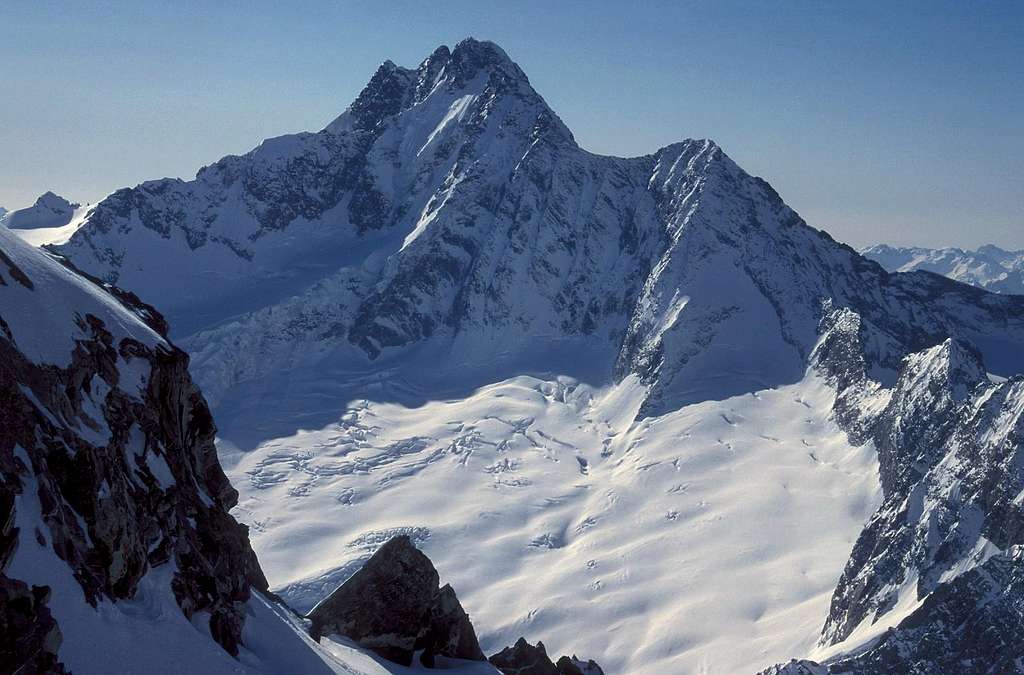
Monte Disgrazia images

|

|

|
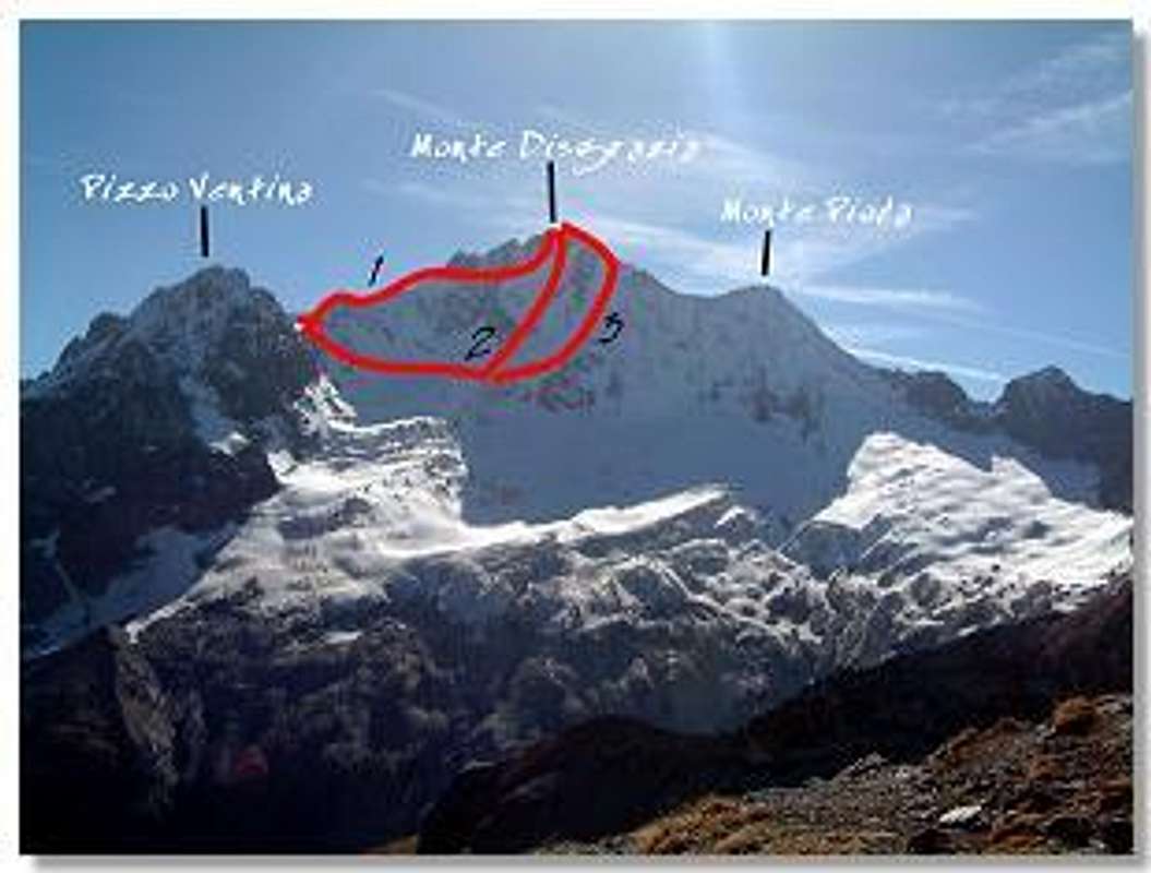
Getting there
The mountain covers 4 leads: Valle Sissone, Val Ventina from north and Valle Airale and Valle di Preda Rossa from south. Also a part of Valley of Mello belong to Monte Disgazia but it is not directly united. All the valleys can be reached from the Valtellina. The first three join to the Valmalenco while the Valle di Preda Rossa can be reached from the Valmasino. The slopes of the mountain host numerous refuges and bivouacs, that allow a comfortable approach from every sides.
La montagna occupa 4 valli: Val Sissone, Val Ventina a nord e Valle Airale e Valle di Preda Rossa a sud. Anche una parte della Valle di Mello è tributaria della montagna ma non direttamente unita. Tutte le valli possono essere raggiunte dalla Valtellina. Le prime tre connesse alla Valmalenco mentre la Valle di Preda Rossa può essere raggiunta dalla Valmasino. Le pendici del Monte Disgrazia ospitano numerosi rifugi e bivacchi, che permettono un comodo approccio da tutti i lati.
Valtellina From Milano From Milano buses or train. Otherwise car following the motorway Milano-Lecco-Colico-Sondrio
Other valleys
- From Val Sissone From the city of Sondrio take the road to Chiesa in Valmalenco (960 m). Once here take the paved road to the village of Chiareggio (1.612 m). All the paths to Val Sissone start from there.
- From Val Ventina Follow the previous route to Chiareggio. Go across the river and take the path to refuge Porro. From Valle Airale From Sondrio take the direction to Valmalenco untill the village of Torre di S.Maria/Ciappanico (1.037 m). From here path to refuge Bosio.
- From Valle di Preda Rossa From Sondrio, direction to Lecco. Get out at the village of Ardenno Masino. Get into the Valmasino untill the hamlet of Cataeggio (791 m). From here take the indication to Valle di Preda Rossa on paved road first and than on path to refuge Ponti.
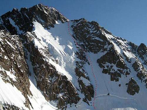
Monte Disgrazia Normal route (WNW Ridge)
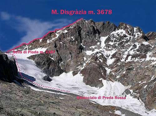
Monte Disgrazia West–North–West ridge report - UIAA Scale
Summit altitude: m. 3678
Difficulty: Alpine PD/PD+, II+ UIAA
Difference in level: 27200 m. from Preda Rossa, 1120 m. from Rif. Ponti
Exposure: WNW
First ascent: : E.S. Kennedy – Leslie Stephen – M. Anderegg – T. Cox 1862, August, 24th
Hut: Rifugio Ponti m. 2559
Starting point: Alpe Predarossa 1950 m
Monte Disgrazia West-North-West ridge – or Cresta di Pioda – is the easiest way to get the summit of this mountain, the highest one of Lombardia. It’s a frequently climbed mixed “course”, alternating snowy ridges and easy rocky steps.
Part I – Scrambling approach from Rifugio Ponti m. 2559 to Sella di Monte Pioda m. 3387
Sella di Monte Pioda m. 3387 is a wide saddle lying between Monte Pioda and Monte Disgrazia. From the hut take a well worn path heading East (red-white marks), getting the edge of the right lateral moraine of Preda Rossa Glacier. Follow the moraine edge; when it ends (cairn), turn to left and rise on a stones-ground (some cairns) heading to a steep rock wall on the orographical right side of the glacier. The route gains the edge of the Preda Rossa Glacier; cross the glacier and climb its steepest section on the left, near the rocks, to avoid the crevasses, getting a terrace below the wide saddle of Preda Rossa, then the saddle m. 3387, where a breathtaking view over the Bernina Group appears (2 hours from the hut).
Part II – Climbing section from Sella di Monte Pioda m. 3387 to the summit of Monte Disgrazia m. 3678
The climb starts from Sella di Monte Pioda. Skirts the first rocks on the right for about 50 meters, then take the ridge, alternating Up the fine ridge, alternating snowy slopes and rocky steps, being aware to the huge cornice protruding to the Disgrazia Glacier. After a steep snow- slope (40°), climb some rocky steps (max II grade UIAA), reaching two small rocky prominces. The rocks are of good quality and are engraved by the crampons’ points. After this rocky section, climb an easier but airy snow ridge, reaching the fore-summit called “Syber-Gysi". After having climbed a steep boulder 5 meters high called “Cavallo di Bronzo” (“Bronze Horse”, II+ UIAA) follow the ending ridge to the tiny summit.
Descent: reversing the route
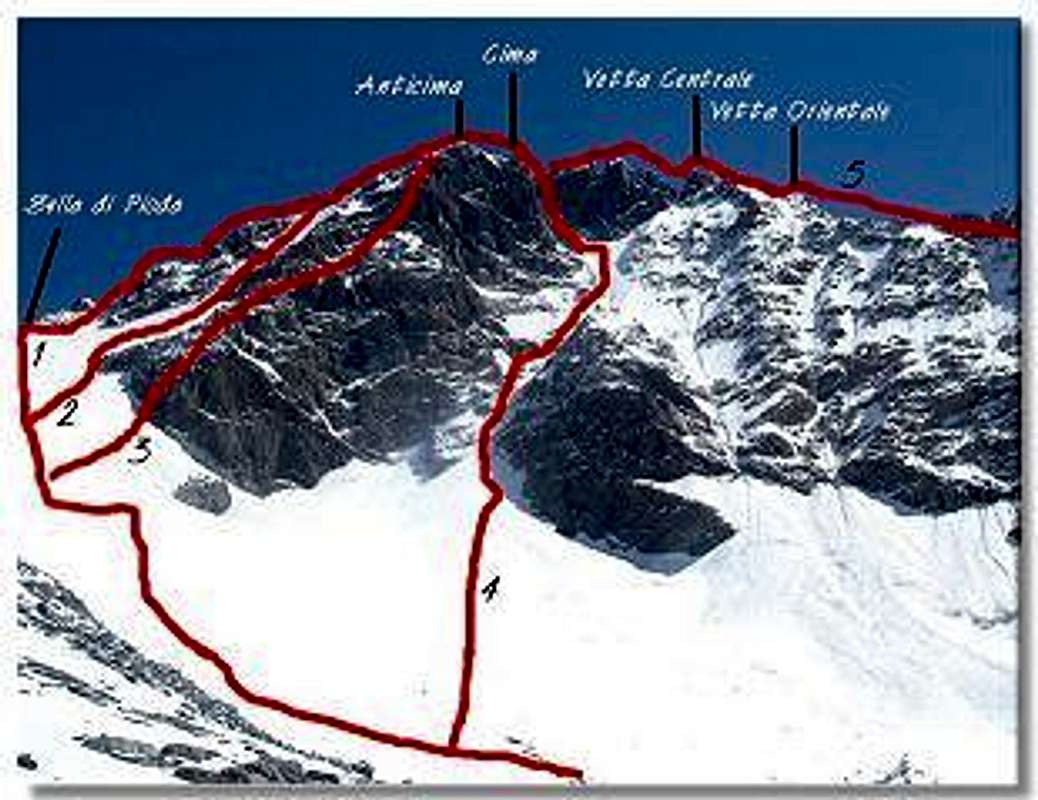
Main routes
ROUTES FROM VALMASINO
- "Normal Route"- Northwest ridge (PD/PD+)
-"Canalone Schenatti" (AD)
-"Via Baroni" Southwest ridge (II°)
- "Direttissima" (AD+ IV°)
- "SW Couloir", (Rydz) (AD/AD+).
ROUTES FROM VALMALENCO
- "Corda Molla", North ridge (AD/AD+) Related Page
- "North Wall", (Albertini, Schenatti 10/07/1934) (TD/TD-) Related Page
- "Via degli Inglesi", North Wall/WNW Ridge (Ling, Raeburn 08/08/1910) (D/D-)
|
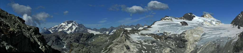
Images of climbs

|

|

|
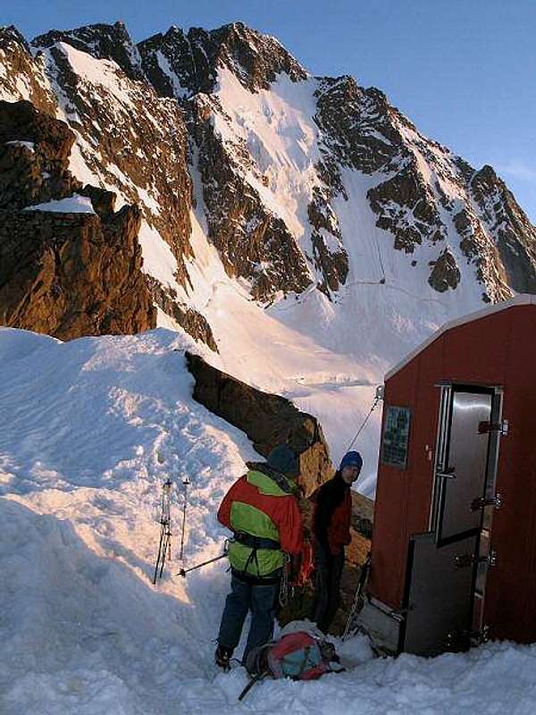
Huts and Bivouacs
Camping is permitted in any area.
- Ref. GERLI PORRO (E) Alpe Ventina (1.965m) tel. 0342/451404. From Chiareggio 1h'30 hours
- Ref. BOSIO (E) Alpe Airale (2.089m) tel. 0342/451655. From Ciappanico 2h'00
- Ref. DEL GRANDE CAMERINI (E) Cresta di Vazzeda (2.660m) tel.0342/556010. From Chiareggio 2h'30
- Ref. PONTI (E) Alpe Preda Rossa (2.559m), places 85 Tel. 0342-640138. From Piano di Preda Rossa 2h'00
- Biv. TAVEGGIA (F) Sentinella della Vergina (2.894m). From ref. Porro 3h'00/4h'00
- Biv. OGGIONI (PD) Colletto Disgrazia (3.151m). From biv. Taveggia in 1h'30
- Biv. RAUZI (AD+) Cima Disgrazia (3.640m). From biv. Oggioni in 5h'00/7h'00
- Biv. ODELLO GRANDORI (PD/E) Passo di Mello (2.992m). From Chiareggio in 4h'00/5h'00 or from Mello in 5h'00
- Biv. KIMA (E) Head od Val di Mello (2.700m). From Mello in 5h'00. (brand new, but placed in a not very useful position).

|

|

|

|

|

|
Meteo
Mountain conditions
Below, the best weather web-site for the local area:
www.aineva.it
www.arpa.it
www.waltellina.com
 |
 |
 |
Guidebooks and maps
Guidebook

“Masino – Bregaglia – Disgrazia Vol. II” by Aldo Bonacossa – Giovanni Rossi – Collana Guide dei Monti d'Italia C.A.I.-T.C.I.
Maps
- Kompass n° 92 "Bernina - Sondrio" 1:50.000
- Multigraphic “Pizzo Bernina – Monte Disgrazia”
- CNS “Monte Disgrazia” 1:50.000