
|
|
Mountain/Rock |
|---|---|
|
|
37.10351°N / 118.71947°W |
|
|
Fresno |
|
|
13568 ft / 4136 m |
|
|
Overview
I inherited this page from Dave K in April 2013 and wanted to give my thanks to him for creating this page and giving me the chance to build on it.
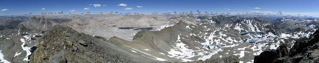
Mount Goddard is a large, dark, isolated mountain located in a remote area of northern Kings Canyon National Park. It is the most massive and dominating peak in its immediate area and is the high point of Goddard Divide.
Mount Goddard is separated from the Sierra Crest and is approximately 500 feet higher than its neighboring peaks. Because of its size and isolation, Mt. Goddard provides an unsurpassed view of most of the High Sierra. As Norman Clyde observed, Mount Goddard “possesses one of the most extensive views that can be had in the Sierra - one commanding the main axis of the range from Mt. Whitney to Mt. Lyell,” which is a span of about one hundred miles of high mountains! Nearly every major peak of the High Sierra is visible from its summit, including Mount Ritter, Banner Peak, Mount Abbot, Bear Creek Spire, Mount Tom, Mount Humphreys, Mount Darwin, and Mount McGee to the north; Black Giant, Mount Solomons, and the Palisades to the East; Charybdis, Mount McDuffie, Scylla, Finger Peak, Mount Reinstein, and the Ionian Basin to the immediate south; and Monarch Divide, the Great Western Divide, the Kaweah Range, Kings-Kern Divide, and Mount Whitney to the distant south. Similarly, Mount Goddard is easily recognizable from nearly every major Sierra summit.
It is one of 15 Sierra emblem peaks designated by the Sierra Peak Section of the Angeles Chapter of the Sierra Club, and all the remaining peaks are visible from its summit save for Matterhorn Peak far to the north and Olancha Peak far to the south.
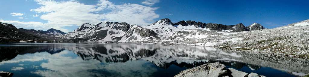
The area surrounding Mount Goddard is very wild, alpine, and high--approximately 11-12,000 feet in elevation. Several lakes are located nearby including Lake Wanda and the Davis Lakes to the north; the Ionian Basin lakes and other small lakes to the south; and Martha Lake to the southwest. Although Mount Goddard can be reached by the John Muir Trail, much of the immediate area is trail-less. Ionian Basin, in particular, is a remote, alpine area requiring class 2 cross-country travel to explore.
Mount Goddard composes part of a 25-mile long mass of dark metamorphic rock. The north side of the mountain contains several small glaciers. Talus covers much of the mountain.
See James G. Moore, Exploring the Highest Sierra.

Getting There
To be updated.
Approaches
If getting there is half the fun, then you will have a blast getting to Mt. Goddard, because there is a whole lot of getting to get there. Many approaches are possible, including:
Florence Lake
Either hike 5.2 miles around Florence Lake or take a ferry across the lake. Proceed up the Florence Lake Trail for another 6.2 miles until reaching the John Muir Trail (“JMT”). Continue up the JMT for 5.6 miles, reaching a trail junction. Then, either hike: 1) 10.5 miles up Evolution Valley along the JMT to Wanda Lake for a north side approach to the East Slope, Northeast Face, or Starr’s Routes; or, 2) 6.8 miles up Goddard Canyon, then follow the South Fork of the San Joaquin River across mostly easy cross-country terrain (with a few boulders) for another 1.5 miles to Martha Lake, for a south and west side approach to the Southwest Ridge/West Chute or West Side Routes.
North Lake
From North Lake, hike 5.0 miles up to Piute Pass (11,423 ft.). Hike down from the pass following the Piute Canyon Trail for 12.4 miles until reaching the JMT. This is a beautiful trail. Continue up the JMT for 3.8 miles, reaching a trail junction. Then, either hike: 1) 10.5 miles up Evolution Valley along the JMT to Wanda Lake for a north side approach to the East Slope, Northeast Face, or Starr’s Routes; or, 2) 6.8 miles up Goddard Canyon, then follow the South Fork of the San Joaquin River across mostly easy cross-country terrain (with a few boulders) for another 1.5 miles to Martha Lake, for a south and west side approach to the Southwest Ridge/West Chute or West Side Routes.
Courtright Reservoir
From the Maxson Meadow trailhead at Courtright Reservoir, follow a jeep trail north for 1 mile then turn right (east) along a trail for 3 miles climbing gently through lodgepole pine and red fir forests until reaching a junction with a trail leading to Hobler Lake. Continue right, avoiding the trail to Hobler Lake. Hike another 3.5 miles, passing through Long Meadow, eventually crossing Post Corral Creek and reaching a junction with a trail leading up the North Fork of the Kings River. Continue on the left (east) trail for Hell for Sure Pass, climbing gently past Fleming, Disappointment and Hell for Sure Lakes. All of these lakes have good campsites. After another 8.4 miles, you should reach Hell for Sure Pass and have your first glimpses of the Mt. Goddard area and beautiful Goddard Canyon. From the Pass, the trail drops 1100 feet in 1.2 miles, then heads southeast for 2.6 miles, paralleling the South Fork of the San Joaquin River, without losing or gaining much elevation before reaching the Goddard Canyon Trail. If you return via the Hell for Sure Pass route, pay close attention because the Hell for Sure Pass trail is marked with ducks—not a sign. Continue south for 1.5 miles up Goddard Canyon, then follow the South Fork of the San Joaquin River across mostly easy cross-country terrain (with a few boulders) for another 1.5 miles to Martha Lake, for a south and west side approach to the Southwest Ridge/West Chute or West Side Routes.
South Lake
From South Lake, hike 6.0 miles up Bishop Pass (11,972 ft.). This is a popular trailhead for approaching the Palisades. Hike down 6.6 miles to LeConte Canyon, which is a very beautiful, deep canyon with lush meadows and forests. Hike north up the JMT for 7.0 miles until reaching Muir Pass (11,955 ft.) and Muir Hut, a round, stone structure built by the Sierra Club. Proceed another 1.5 miles until reaching Wanda Lake for a north side approach to the East Slope, Northeast Face, or Starr’s Routes.
Wishon Reservoir (Courtesy of Mthilgard13)
The Woodchuck trailhead at Wishon Resv. is an alternate route that can be used instead of Courtright Reservoir. Albeit a long approach, this approach is certainly one with fewer people and raw scenery. Leave Woodchuck (6600 ft) and hike towards Woodchuck Country and over Crown Pass (10200 ft). A long first day can be humped all the way to the exceptionally beautiful Halfmoon Lake (9400 ft, 15.5 miles). Next, continue heading east over the obscure Scepter Pass and along the North Fork of the Kings River. Soon after you cross an old wooden plank walkway over a meadow near the end of the North Fork canyon, leave the trail and head southeast to find the stream draining the southern section of Blackcap Basin (beautiful wide open granite basin). Follow subsequent streams, veering eastward towards Ambition Lake and then Valor Lake. Head over Valor Lake and to Valor Pass (11000-11500ft). It's all class 2 up to the pass and over the other side, but be cautious on the east side (there is a decent chute). Either go to Martha Lake and then up to Goddard Col, or traverse above Martha to Goddard Col (as I did, pretty uncomfortable). Valor Pass is a very direct route to Martha Lake and Goddard Col.
Other variations include crossing a few eastside cross-country passes such as Lamarck Col from North Lake or Echo Col from Sabrina Lake, which as Steeleman notes, is a lower and more direct eastside route than Lamarck Col (although more difficult, too). Another option is to traverse Ionian Basin from Muir Pass and establish a base camp at Martha Lake or Lake 12,240 southwest of Mount Goddard.
Route Overview
* Two class 2 routes, including Starr’s Route, originating from the north side of the peak, and the East Slope;
* One class 2-3 route: the Southwest Ridge/West Chute;
* One class 3 route: the West Side Route;
* One 5.8 route: the Northeast Face, which involves climbing over much loose rock.
See R.J. Secor, The High Sierra: Peaks, Passes, and Trails, or Steve Roper, The Climber’s Guide to the High Sierra (out of print), for additional information on routes.
Red tape
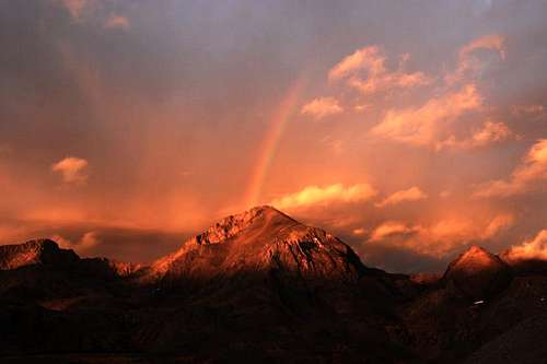
Rainbow on Mount Goddard
Wilderness Permits:
Even though Mount Goddard lies in Kings Canyon National Park, most visitors will be entering from either Sierra National Forest to the west or Inyo National Forest to the east. A wilderness permit is required for overnight stays, and you only need to obtain a wilderness permit for your entry point. For example, if you enter in Sierra National forest, you do not need to obtain an additional permit for Kings Canyon National Park.
Thus, only one permit is needed per trip. Quotas are in place year round. If approaching from the west permits are most conveniently picked up at the High Sierra Visitor Information Station on Kaiser Pass Road (one mile before the split between Lake Edison and Florence Lake, open seasonally) or the High Sierra Ranger District office in Prather. Check the Sierra National Forest permit website for the most current information. If approaching from the east you will begin in Inyo National Forest and permits can be picked up at the White Mountain Ranger Station in Bishop.
Quotas here are in place from May 1 through November 1. Check the Inyo National Forest wilderness permit website for the most current information and reservation availability.
Food Storage:
No bear canisters are required, but proper food storage is a must.
Campfires:
Fires are prohibited above 10,000 feet.
| High Sierra Ranger District Office 29688 Auberry Rd Prather, CA 93651 (559) 855-5355 |
Inyo National Forest Wilderness Permit Office 351 Pacu Lane, Suite 200 Bishop, CA 93514 Wilderness Information Line: (760) 873-2485 Permit Reservation Line: (760) 873-2483 |
Current Conditions
Current NOAA / National Weather Service Forecast
When To Climb
June-October. Winter climbs are possible but difficult because of the remote location.
Camping
Most climbers camp at either Martha or Wanda Lakes.
Early Exploration and Etymology
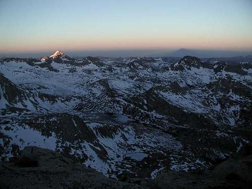
Mount Goddard at First Light
“‘Thirty-two miles north-northwest is a very high mountain, called Mount Goddard, in honor of a Civil Engineer who has done much to advance our knowledge of the geography of California, and who is the author of ‘Britton & Rey’s Map.’’ (Whitney Survey: Geology, 1865, p. 382.) George Henry Goddard was engaged for several years (1853-1855) in surveying for a practical wagon route across the Sierra Nevada.
In 1855 he ascertained that the boundary angle between California and the then territory of Utah was situated in Lake Tahoe and not, as supposed, in Carson Valley. He prepared a map of California, published by Britton & Rey in 1857. Born in England about 1817; naturalized American citizen, 1861; lived in San Francisco for many years. (U.S.C. & G. Survey: Report for 1900, appendix 3, p. 264. Report of Surveyor-General of California, 1856, p. 101.)”– Francis P. Farquhar, Place Names of the High Sierra (1926)
Richard Cotter and Spratt (a soldier whose first name was not recorded), members of William Brewer’s 1864 party, made the first recorded attempt to climb Mt. Goddard. Brewer’s party was on a mission to map and explore much of the High Sierra. They knew that Mt. Goddard’s high elevation and isolation would allow them to view much-unmapped territory. However, Cotter and Spratt failed to reach the summit by 300 feet.
William Brewer’s account of this attempt (provided by Bob Burd), from the book “Up and Down California,” says:
We are again back here, stopping over a day, and I will go on with my story. And yet I have a mind to pass it over, it is so like the rest. Rides over almost impassable ways, cold nights, clear skies, rocks, high summits, grand views, laborious days, and finally, short provisions -- the same old story.
Yet one item is worth relating. A very high peak, over thirteen thousand feet, rises between the San Joaquin and Kings rivers, which we call Mount Goddard, after an old surveyor in this state. It was very desirable to get on this, as it commands a wide view, and from it we could get the topography of a large region. Toward it we worked, over rocks and ridges, through canyons, and by hard ways. We got as far as horses could go on the ninth [of August], and thought that we were within about seven miles. of the peak [approaching from the northwest].
We camped at about ten thousand feet, and the next day four of us started for it -- Hoffmann, Dick [Cotter], Spratt (a soldier), and I. We anticipated a very heavy day's work, so we started at dawn. We crossed six high granite ridges, all rough, sharp, and rocky, and rising to over eleven thousand feet. We surmounted the seventh, a ridge very sharp and about twelve thousand feet, only to find the mountain still at least six miles farther, and two more deep canyons to cross. We had walked and climbed hard for nine hours incessantly, and had come perhaps twelve or fourteen miles. It was two o'clock in the afternoon. Hoffmann and I resigned the intention of reaching it, for it was too far and we were too tired.
Dick and Spratt resolved to try it. We did not think they could accomplish it. Dick took the barometer and I took their baggage, a field-glass, canteen, and Spratt's carbine, which he had brought along for bears. Hoffmann and I got on a higher ridge for bearings, and then started back and walked until long after sunset -- but the moon was light -- over rocks. We got down to about eleven thousand feet, where stunted pines begin to grow in the scanty soil and crevices of the rocks. We found a dry stump that had been moved by some avalanche on a smooth slope of naked granite. We stopped there and fired it, and camped for the night.
We had brought along a lunch, expecting to be gone but the day. It consisted of dry bread and drier jerked beef, the latter as dry and hard as a chip, literally. This we had divided into three portions, for three meals, a mere morsel for each. This scanty supper we ate, then went to sleep. The stump burned all night and kept us partially warm, yet the night was not a comfortable one. Excessive fatigue, the hard naked rock to lie on -- not a luxurious bed -- hunger, no blankets -- although it froze all about us -- anxieties for the others who had gone on and were now out, formed the hard side of the picture.
Early in the evening, at times, I shouted with all my strength, that Dick and Spratt might hear us and not get lost. The echoes were grand, from the cliffs on either side, softening and coming back fainter as well as softer from the distance and finally dying away after a comparatively long time. At length, even here, sleep, "tired nature's sweet restorer," came on. Notwithstanding the hard conditions, we were more refreshed than you would believe. After months of this rough life, sleeping only on the ground, in the open air, the rocky bed is not so hard in reality as it sounds when told. We actually lay "in bed" until after sunrise, waiting for Dick. They did not come; so, after our meager breakfast we started and reached camp in nine hours. This was the hardest part. Still tired from yesterday's exertions, weak for want of food, in this light air, it was a hard walk.
At three in the afternoon we reached camp, tired, footsore, weak, hungry. Dick had been back already over an hour, but Spratt had given out. Gardner and two soldiers, supposing that Hoffmann and I also had given out, had started with some bread to look for us. We shot off guns, and near night they came in, and at the same time Spratt straggled into camp, looking as if he had had a hard time. Dick and he did not reach the top, but got within three hundred feet of it. They traveled all night and had no food -- they had eaten their lunch all up at once. Dick is very tough. He had walked thirty-two hours and had been twenty-six entirely without food; yet, on the return, he had walked in four hours what had taken Hoffmann and me eight to do.
On September 23, 1879, Lilbourne Winchell and Louis Davis became the first persons reported to have climbed Mt. Goddard via the Southwest Ridge/West Chute.
Bob Burd - Sep 20, 2005 11:25 pm - Voted 10/10
Untitled CommentAfter some practical field study, I think it is safe to say that the quickest and easiest way to get to Goddard is via Lamarck Col. The route is nearly all on trail and shorter than any of the other routes listed. Just thought I'd mention this because I thought it should be more prominently displayed in your fine list of routes rather than as an afterthought at the end. Another cross-country route that may be better than Echo Col and is the shortest route going strictly by miles, is over Haeckel Col. That route was not field tested and is almost assuredly slower than Lamarck Col.
asmrz - Jul 5, 2015 4:38 pm - Hasn't voted
Lamarck Col approach goes just finePen and I found Lamarck Col preferable to the cc 24 miles of trail from South Lake over Bishop Pass and to Wanda Lake. Lamarck Col might have 3,600' of gain starting from North Lake but gets you to Wanda Lake in only 14 miles. The Piute Pass approach is very long, I did it in the late 90's and would not recommend it.
icescrew - Aug 20, 2016 8:56 am - Hasn't voted
Lamarck Col was the bestI tried to reach Goddard from Florence Lake and from South Lake. Lamarck Col was much shorter and very scenic. The National Forest has also improved the trail between Lamarck Lakes and the Col in recent years making it easier. But the trails are thin and scattered in Darwin Canyon. Perhaps the National Park should put a trail in there since many people seem to be hiking through the canyon these days.
T. White - Jan 13, 2020 11:35 pm - Hasn't voted
Re: Lamarck Col was the bestThis is great info. I never knew the trail was improved that far, but it sure looks clean on satellite view...