
-
 188100 Hits
-
 99.62% Score
-
 124 Votes
|
|
Mountain/Rock |
|---|---|
|
|
46.19140°N / 122.1933°W |
|
|
Skamania |
|
|
Hiking, Skiing |
|
|
Spring, Summer, Fall, Winter |
|
|
8365 ft / 2550 m |
|
|
Pre-eruption Photos
 |
 |
 |
 |
 |
Overview

The current Mt. St. Helens VolcanoCam image.
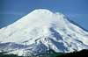
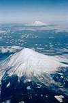
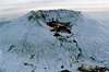
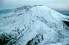
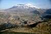
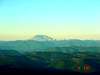
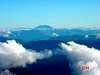
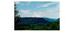
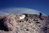
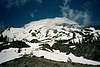
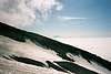
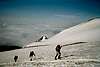
Even before May 18, 1980 when Mt. St. Helens blew its top sky-high while vaporizing a vast area to its north, it was the smallest of Washington's 5 volcanoes at 9677 ft (2950 m). The blast removed far more than that 1312 feet from the height of the mountain. It left a mere shell of what had been a beautifully symmetrical cone. The melting of several glaciers contributed to the massive floods. Sliding earth buried wonderful stands of virgin forest and recreational facilities and killed untold wildlife. A beautiful tree-lined lake was dammed to a higher level and filled with heat-stripped logs. Condensed rock vapor was carried on the wind to be deposited up to thousands of miles away.
For seven years recreational climbing was banned on Mt. St. Helens. Then in May 1987 it was reopened. Only the south routes are still allowed. Access to the crater is strictly forbidden.
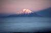
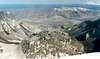
On clear mornings I can see the mountain as I drive out of my neighborhood to work. That view is a constant reminder of the power of nature. I have always regretted that I had moved from Vancouver, WA to Juneau, AK only three months before the eruption. I returned two years after the eruption, but I missed out on all the excitement. When the mountain blew its top, a part of me went with it.
 |
 |
 |
 |
 |
Getting There
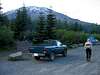
From Interstate 5 at Woodland, take the exit for State Highway 503. Drive past Lake Merwin and Yale Lake. Then just after the Swift Reservoir viewpoint, turn left on forest road 83. Follow the signs to Climber's Bivouac, which involves a right turn onto forest road 830.
 |
 |
 |
 |
Red Tape
Please read thoroughly this page from the Mt. St. Helens National Volcanic Monument for information about obtaining permits to climb Mt. St. Helens. A permit is required above 4800' on the mountain. I will not attempt to reproduce all of the red tape requirements on this page. The link above leads to the definitive source of this information.
When To Climb
St. Helens is best climbed during the permit season, with optimal conditions occuring from May through September.
Additional information posted by John: However, don't let winter prevent you from hiking up this stratovolcano. St. Helens is popular from February to early-summer for snowshoe and ski / snowboard summits. A bonus is that you'll get away from the permit quota hassle though you will need a WA or OR Sno-Park permit if you are parking at the Marble Mountain Sno-Park. Check the Books section for Dan Nelson's "Snowshoe Routes : Washington" or Amar Andalkar's Ski Mountaineering and Climbing Site for additional info.
Additional comment posted by ben: Climbing in the winter also means that you can avoid the scree and ash that is the bane of a summer climb - two steps up, one step backsliding.
 |
Camping
Please read this page from the Mt. St. Helens National Volcanic Monument for information about camping near the mountain.
Mountain Conditions
Click here for current weather information.
 |
 |
 |
 |
External Links
- Amar Andalkar's Ski Mountaineering and Climbing Site
Routes, photos, links, and information about climbing Mt. St. Helens. - St. Helens (08/21/2000)
- Zeitcam.com
Time Lapse movie of Mt. St. Helens Web cam and other mountains. - Mount St. Helens via Monitor Ridge
jeffreyking - Jul 15, 2002 12:02 pm - Hasn't voted
Untitled CommentThe Climber's Bivouac has somewhat of a noteriety for being one big party on evenings during the summer. If you plan on getting some sleep and want an early start, I recommend camping about 100 yards down the approach road or perhaps off the Ptarmigan Trail.
millsb40 - Sep 29, 2004 10:30 am - Hasn't voted
Untitled CommentMeasurements taken by GPS stations recently placed on Mt. St. Helens show the lava dome is expanding and earthquakes continue yet more frequent. Odds are, this Mountain will be closed to climbing for a while... Update 07-12-06. The Mountain will be re-opening to climbing, see the Gifford Pinchot web page http://www.fs.fed.us/gpnf/recreation/mount-st-helens/ for more details.
mutant1 - Oct 20, 2004 10:47 am - Hasn't voted
Untitled CommentA good view into the active crater is available from Goat Mountain.
D Smith - Feb 9, 2005 12:28 pm - Hasn't voted
Untitled CommentJust as a side project, I recently started a Website that makes time-lapse movies of still-image Web Cams in the PNW and abroad. Mt. Saint Helens is a really fun one to watch when it's letting off steam:
http://www.zeitcam.com/showcam.php?cam=sainthelens&day=20050209
(click on previous days links if nothing interesting shows up initially.)
Let me know what you think! (still a work in progress...)
-Dave
Bob Bolton - Feb 9, 2005 9:40 pm - Hasn't voted
Untitled CommentAwesome Dave!! Thanks a million. I'll make a new section on the main page and include the link. Will this thing automatically adjust for changing daylight hours?
Bob
D Smith - Feb 10, 2005 12:04 am - Hasn't voted
Untitled CommentThat's feature is "in the works"...right now I just have a cron job run from 9 to 5 PST -- works well for St. Helens in Winter, but not summertime or European cams.
Angela - Jun 12, 2007 8:21 pm - Hasn't voted
PermitsPermits are now issued exclusively on line. A confirmation is emailed to you and you stop in at Jack's where you sign in and recieve your climbing permit.
Bob Bolton - Jun 12, 2007 10:21 pm - Hasn't voted
Re: PermitsThanks Angela - you're right, I need to update that information. -Bob
Redwic - Aug 30, 2008 12:45 pm - Voted 10/10
Permit Pickup Location...After ordering a climbing permit online, the receipt needs to be taken to Lone Fir Resort (in Cougar, WA) to receive the actual climbing permit. As of June 6 , 2008, the Mount Saint Helens Climber's Register was moved to the Lone Fir Resort. The Lone Fir Resort is located on State Route 503 in the town of Cougar, WA at 16806 Lewis River Rd. Phone (360) 238-5210. The Climber's Register is self-service and is located outside the Lone Fir Resort. For your safety, please be sure to sign in and sign out at the register.
Bob Bolton - Sep 3, 2008 2:28 am - Hasn't voted
Re: Permit Pickup Location...Thanks -- appreciate the note! I changed the text to reference the Lone Fir Resort and included a link to their website. The other links on the page will lead to the pickup location. That should suffice I'm thinking. -Bob
Summiteer - Aug 19, 2015 12:09 pm - Voted 8/10
Great beginner climbNot the toughest climb but very good for the beginner. I would recommend climbing it in early spring as the snowy views are much better for pictures. Also, in the summer, the volcanic dust can be a bit unbearable.
kw - Sep 19, 2020 5:11 pm - Hasn't voted
New Permit WebsiteThe page listed under Red Tape is a dead link, the updated link for Permit Information is https://www.recreation.gov/permits/4675309
deeph2o - Jan 18, 2021 11:20 am - Hasn't voted
Permit Info-and-the mountain.I should have posted this more than a year ago, but here is my experience: 1. Got a permit for July 2, 2019. If I recall, the permit site was originally supposed to be handling requests in early February, but then was postponed until early March, 2019. 2. The permit was emailed to me, and I just printed it out. Very important, since I was on a 2-day road trip from the Midwest, and I had to make sure I had a printout of the permit, AND that I not lose it-but it made things easier, in that I didn't have to go to any other location, before climbing. 3. Got to Cougar @ 6:00 on 7/1, went to Ape Cave, then got out and went to Climber's bivouac. 4. As others mentioned, it was a bit of a party place, it seemed. There was a large group, and a number of 2-person groups camped out. As it turns out, the large group was a Boy Scouts group, but regardless, the sound travels through all the campsites very easily. 5. Summit day was pretty straightforward. On the trail by 6:30, and we took our time, got to the summit around 11:30. It was cloudy and cool all morning, and there was about a 30 minute window where we could see Adams on Monitor Ridge. Gloves are recommended-I had garden-type rubber palm gloves-they protected my hands from scraping on the rocks, but they got cold, as I exerted enough to sweat in my hands. The route is marked with wooden poles which are staggered along the trail. Still, it is easy enough to lose track of them, if, as happened to me, the mountain got clouded-in. Take it slow, and be sure to re-orient as necessary.