
-
 21500 Hits
-
 84.27% Score
-
 18 Votes
|
|
Mountain/Rock |
|---|---|
|
|
46.38240°N / 9.42140°E |
|
|
Mountaineering, Skiing |
|
|
Spring, Summer, Winter |
|
|
10377 ft / 3163 m |
|
|
Overview
| One of the most popular summits of Lombardia and of Central Retic Alps, almost the symbol of Valle Spluga Due to wonderful panorama, easy access and, of course, very fine appearence, it is often climbed by hikers, beginners and all those who want to make a relaxing and safe climb. It is a real mountain, normal route requires 3h and a half from Angeloga crossing a small glacier (vedretta del Mortee), difference in elevations is 1120 m. 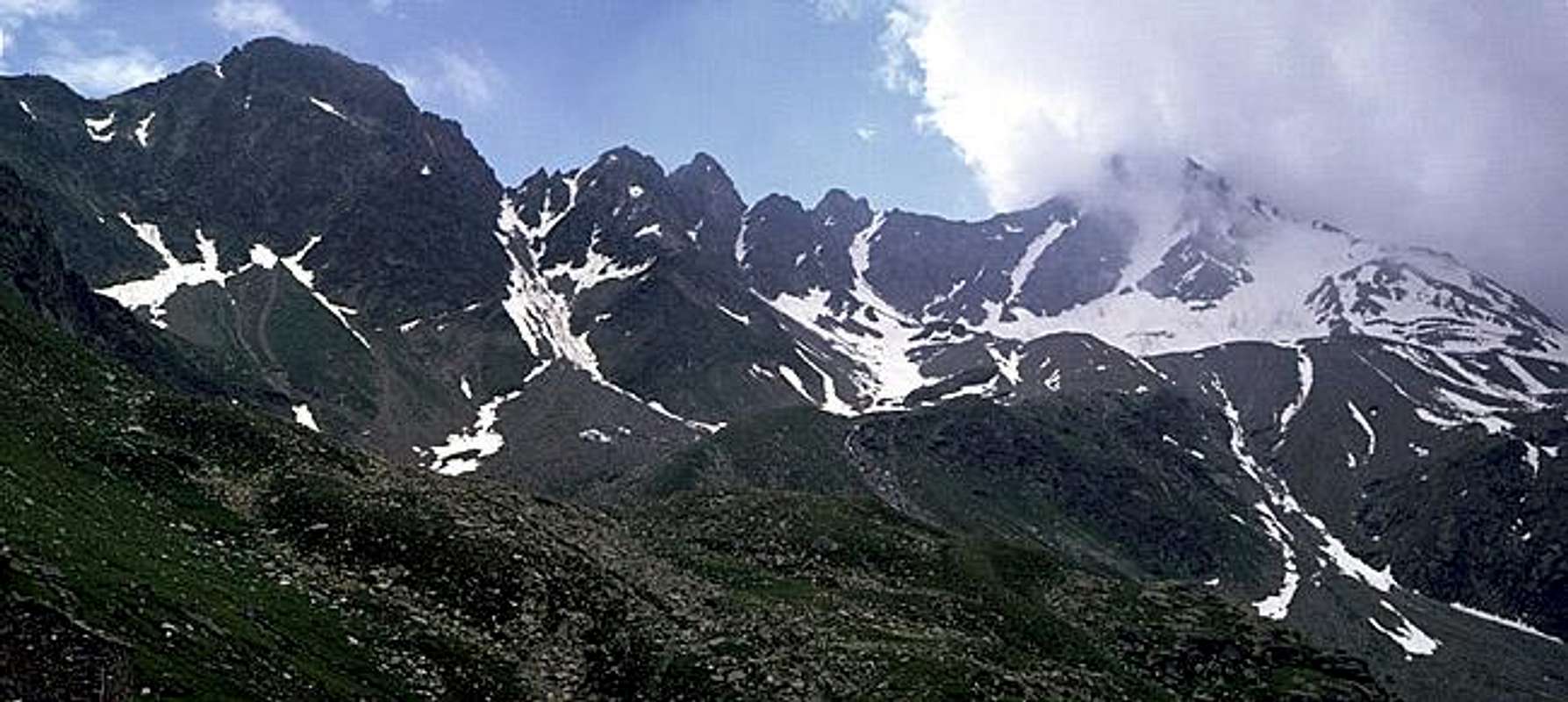 This has been my first summit when I was not yet 17 : I was hiking with some friends of mine and seeing two people coming down from Pizzo Stella I felt the need to go to the summit, borrowed a small tourist alpenstock (? pick) and in 2 hours I was, all alone, on the summit ... that was the starting point of one of the most important passions of my life
|


Routes overview
from Angeloga 5 interesting summer routes : normal route - easy (F) follows the slopes on the west side of the vedretta del Mortee the NW side of the mountain allowing to get the West ridge, easy walking canalone centrale - (PD-AD) - the most straight route to the summit - to be done only with good snow and early in the season (june-july) - grade up to 45°, amusing and very good to start snow-routes experience canalone "vittoria" - (PD-AD) - the left channel looking at the summit from Angeloga - not so fine as canalone centrale - to be done only with good snow and early in the season (june-july) canalone "federica" - (PD-AD) - the channel on the left, brings to the north ridge over the spurs coming from Pizzo Peloso southward - to be done only with good snow and early in the season (june-july) from Passo Angeloga - along the Ponciagna glacier (the ski-mountaneering route) - (F) - longer than the previous routes and a little boring ... channels routes require ice-axe (and crampons), for normal route axe can be useful only in the early season, I've been told that Mortee glacier has almost disappeared so that one could get the top walking only on stones. ski mountaneering info |
Getting There
| The starting points are Campodolcino and Madesimo - in valle Spluga This summit is normally, and almost exclusively climbed starting from Alpe Angeloga (Rifugio Chiavenna - 2044m)  - -  where you can arrive in two different ways : - from Madesimo - at the beginning of the inhabited area, on the right side, a route brings you (by car) till Alpe Motta Bassa (1720 m). Starting on foot from here you must reach Alpe Motta Alta (lago Azzurro - 1850m) where a path southward lets you cross the western slopes of Pizzo Groppera and, with a very fine, amusing, panoramic and not tiring walk you can get the Alpe Angeloga (fine small lake) and the Rifugio Chiavenna. (1h 30' from Motta Bassa) - from Campodolcino - just at the beginning of the inhabited area (coming from the valley) a route on the right side brings you till Fraciscio (1341m). Here you leave the car and with a fine and various walk along the Val Rabbiosa in 2 hours you can reach the Alpe Angeloga additional info provided by Mathias Zehring North of Pizzo Stella is "Valle di Lei" valley. It's water run into the Rhine river, but the whole valley still belongs to Italy as does the 7 km long Lago di Lei lake damed up by a beton wall. Climbing Pizzo Stella from this side can only be recommended if you can use a bike for the 10 km long route along the Lei valley. Getting there is in Switzerland: a) from north from Chur via Thusis into the Hinterrhein valley and following the San Bernardino Route until Andeer b) from south from Ticino crossing the San Bernardino tunnel also until Andeer Then along the narrow Avers valle until Innerferrera (1480 m). Driving with private car is possible until the dam wall of Lago di Lei (1950 m) Routes from the southern end of the lake to the summit: - glacier route via the Ghiacciaio Ponciagna glacier: not difficult if snow conditions fit: Crevasses esp. at the lower part - NE ridge: easy scrambling - E-flank: much scree, better for descent Best time for a ski tour is probably end of May or the beginning of June - when the the road along the lake is free of snow but still snow in the higher regions. Map: swiss map 1:50000 Nr. 267 "S.Bernardino", also available with ski routes Book in german: Tubbesing, "Berge der Schweiz", 1992, ISBN 3-7634-1068-6 out of print
|


When To Climb
|

Accomodations
| Rifugio Chiavenna (see getting here section) is the best accomodation for most of the routes to this mountain. There is a small hut at the end of Lago di Lei: Pian del Nido, it is always open. Another bivouac is on Passo di Lei (Bivacco Chiara e Walter), from where the summit can be reached directly. Great view in direction of the Bregaglia chain! Here you can arrive starting from Rifugio Savogno Or you can stay at Baita del Capriolo, a restaurant next to the dam of Lago di Lei. The food's great!! And the owner has a few bikes for rent: You can use a bike to reach the end of the lake, he'll pick them up later. |
Camping
| no need, this summit can be climbed in one day trip from the north-western area of Lombardia (I) or Canton Ticino (CH) starting from Madesimo-Motta Bassa |