|
|
Mountain/Rock |
|---|---|
|
|
42.03578°N / 80.12921°E |
|
|
Mountaineering |
|
|
Summer |
|
|
24406 ft / 7439 m |
|
|
Overview
Note: Some of the info on this page is from the former caretaker of the page and I'm not sure how reliable it is. I hope to find some time to make some updates soon.
There are five mountains over 7000m in the area which once were the Soviet Union. The second highest and by far the most difficult is Peak Pobeda. It's a border peak between China and Kyrgyzstan.
Its South eastern realms are on the territory of China, and the border with present day Kyrghyzstan runs over its summit and the west and east ridges. On the Chinese side its called Mount Tomur, and as it is so completely different from that side, as well in mountaineering history, in Topography and in the technical details of climbing it, I think that lateron I will compile a seperate page for describing Mount Tomur.
In present years Pobeda is climbed at least by a few parties every year, but the percentage of Western teams is still very low, and an overwhelming majority of the ones that reached the summit have been Russian nationals, not in the last place because one needs to ascend it to become "snowleopard"
Officially nowadays it is given that the mountain was first climbed by a party led by the famous Vitaly Abalakow in 1956, but SP member Peter Schoen recently pointed out that it might already have been ascended as early as 1938.
So, what is the case?: To commemorate the 20th anniversary of the Komsomol, the youth organisation of the Soviet Communist party, in 1938 a team of climbers was sent out into the Central Tien Shan and here climbed what they were convinced of was the highest summit of the entire range. They measured the peak with an old airplane altitude meter as 6900 meter and named it "20 Komsomol".
In 1943 another party was out in the region, this time on a geographical sortie to commemorate the Soviet victory over the nazi armies at Stalingrad. Having excellent equipment they were able to determine the exact height of the peaks and came to the conclusion that the highest was a stunning 7439 meter, a value that has held out until the present. They also determined that it was the same peak as "20 Komsomol", but renamed it "Pobeda" (=victory), in honour of the Stalingrad battle.
How to explain the great difference in height? Luis Trenker, an authority on mountaineering history, in his book "Die schonsten berge der welt" comes with the following theory: The old airplane altimeter that the Komsomol party used was broken and indeed they did climb the summit of Pobeda. What is true or not we will probably never know.
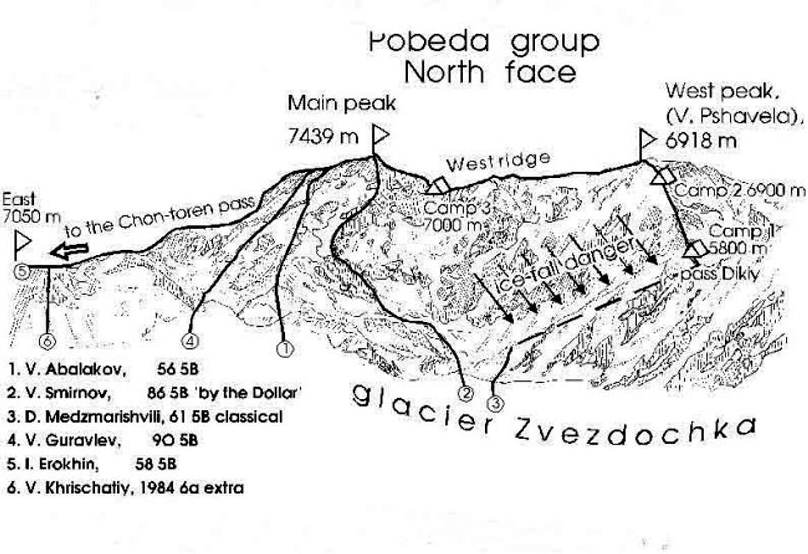
Pobeda is difficult an quite dangerous to ascend on all routes. The very elaborate ones the two first parties took to the summit are seldom taken Nowadays, and the most popular route now is the "classical" opened in 1961 by a team under leadership of D. Medzmarishvili. Still it is of Russian Grade 5B, (which might even be slightly underrated), so pretty tough.
The other five routes on the Northern flank are all 5B or more difficult. Succes rate at Peak Pobeda is still very low if compared with other high peaks and the death toll has been frightningly high: There have been times that 1/3 who made it to the summit did not come down alive again, and in this it can be counted as one of the most dangerous peaks there is in asia.
The reasons for the high fatality rate are various: First, the classical route involves following the West ridge for 12 kilometer(!) towards the summit and it is all above 7000 meter. Second, Together with Khan Tengri, Pobeda forms the Northernmost pair of 7000+ peaks on the globe, hundreds of kilometers to the North of the well known Himalaya and Karakoram giants, resulting in extremely cold conditions. Third, on several routes, but specially on the "classical", there is grave avalanche danger.
Last but not Least, the Russian style of climbing differs from Western ones, in the sense that often much greater risks are accepted, and it is also well known that, being often poor, many Russian climbers are not to well equipped.
Although having a great urge to climb this peak myself, (Have done 3 out of five of the "snowleopard" peaks and the other, Korzhenevskaja, should not present to much of a problem), I did not get the chance for it yet. As a proffesional expedition leader I have to go where the clients want to go, and that has not been Pobeda yet in our case. In fact we cannot blame them for avoiding such dangerous and difficult one, if others, equally counting, are available! The one time that I was in the Inylchek region, time was short and the choice fell on Khan Tengri instead.
Routes Overview
Getting There
To Kyrgyzstan - by air
Most travelers arrive in Kyrgyzstan by air. Manas International Airport is linked with many Asian and European airports. The cheapest fares are found if you look into what Aeroflot and Pulkovo airlines have to offer. A visa can be bought on the spot in Manas Airport. Taxis to Bishkek, which is about half an hour away is readily available at all times of the day, but be sure you know where you are headind as some drivers have commission from some upmarket hotels where you may not want to go.
To Kyrgyzstan - overland
There are two entry points from China: Torugurt Pass and Irkestam Pass. The former can only be traveled in group and by pre-arranged transport. Agents in Bishkek and Kashi (the staging point on the Chinese side) can arrange this for about 100$/person. The travel takes about 2 days in mini bus. Irkestam Pass is easier in terms of permits. You can take off on your own with yur passport only and border formalities are easy and straight forward. Be careful with your gear on the Kyrgyz side though. Reports about stolen equipment are quite common. Expect to wait for long times at the border crossing if you're unlucky to arrive at the same time as one of the large truck convoys.
There are other border crossings to and from Kazakhstan, Tajikistan and Uzbekistan. They can be traveled without any special permits and in general quite straight forward, but rigorous luggage checks are common. If you want to leave the country to Tajikistan's Pamiri-Badakhshan province a special travel permit is needed and it has to be applied for from the ministry of foreign affairs in Dushanbe.
To Pobeda
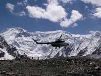
All climbs of Peak Pobeda from the North start from Base camps on the Zvesdochka glacier, a tributary of the great Inylchek glacier, one of the longest non polair ones there is. Trekking in to base camp is thus a very elaborate and not very feasible way of getting there and very few parties do so. If however wanting to try, one should fly in to Bishkek the capital of Kyrghyzstan by any convenient international flight. From here take road transport to the village of Inylchek and proceed the whole length of the glacier. As however porters are virtually absent, (During communizm it was thought of as "not done" to have others carrying your shit and the service has never really developed), and pack animal transport is very problematic, -like it is on all glaciers-, so only for very strong, very lightweighted parties this may be an alternative. It is much more convenient to arrange for flying in from Bishkek by MIG 17 helicopter, a service readily available, but expensive, especially for small parties. I do not want to say that others have not good services, but Bishkek based "Dostuck Trekking" an outfit run by Nicolai Shetnikov is very competent and fair priced for making arrangements for your group.
Red Tape & Permits
Kyrgyzstan
Visa.
For most nationals a pre-arranged visa isn't necessary anymore. You can fly straight to Bishkek international airport and buy one upon arrival. The cost varies for different passport holders. Count on $30-$100 depending on nationality and planned period of stay. Usually 7 day, 1 month and 1 year visas are available, but sometimes it's possible to get other validity times. Multiple entry visas are also available at the airport. An odd thing is that visas are actually cheaper getting them in the airport than getting them from a Kyrgyz embassy.
Make sure you have cash handy as it's sometimes close to impossible to get any at the airport until you have passed the customs, which you of course can't pass until you have a visa for Kyrgyzstan.
Kyrgyzstan Info
Kyrgyz embassy in USA
Kyrgyz embassy in Germany
Climbing permit.
China
Visa.
Climbing permit.
Peaks in between 7000 and 8000 meters cost 1080$. The permit is officially valid for a group up to 10 persons + leader. The price isn't negotiable, but the group size is. I encountered a 23 person group climbing on the same permit once.
Applications for a climbing permit should be sent to the local Chinese Mountaineering Association (CMA) office well in advance. For popular peaks the procedure can be handled in a couple of days, but for a peak like Tomur it may take a long time.
When To Climb
The best period for Pobeda is mid June to mid August.
Very few attempts have been made out of season.
Camping
Kyrgyzstan is a country of nomads and there's a lot of people "camping" all over the place. It's usually not a problem to pitch a tent anywhere in the country. If in doubt, ask. On the walk in to Pobeda camping is the norm and at BC you either camp in your provider's area or if you have none - pitch your tent wherever you like.
If there's space you can rent a place in one of the providers larger tents.
On the Chinese side the normal Chinese rules apply. Officially camping is forbidden, but I've never been bothered and if you ask if you can pitch a tent there's a very slim change anyone says no. There's no semi permanent BC like the one on the Kyrgyz side.
Mountain Conditions
The peak is infamous for it's hard weather. No 7000m peak is further north (not counting Khan Tengri, more here) and it's located in place which is perfect for fast and violent weather changes. In the east the mighty Taklamakan desert, with enormous amounts of hot air rising. In the west a long valley which leads straight down to a big lake (Issuk Kul) and to the north and south huge mountain areas are located.
Very fast weather changes is the norm and so is hard wind on the long summit ridge. Avalanches are frequent on all routes.
Tomur Feng - The Chinese side of Peak Pobeda
Few mountain ranges form such a natural border as the Central Tien Shan. The group to which Pobeda and Stina belong to forms a rough and high, but also very beautiful barrier which is sometimes called the Marble Wall. The chain has throughout history been an international border, geographically and politcally between China's Western extremities and Turkish and Russian influences. Although in the 19th century Tsarist Russia frequently invaded Western China, even the Tsarist Imperialist saw the logic of having the Marble Wall as the border and thus the Eastern and Southern approaches of Pobeda have always remained on Chinese territory.
In China the peak is called Tomur, which means iron mountain in the local Uyghur language. One thing is however not to much different from the other sides: Tomur is very difficult and dangerous to climb. A strong team from the China Mountaineering Association finally succeded to scale it in 1977 after several fruitless tries. As far as I know the climb has up to now never been repeated.
Climbing history
Thanks to Vladimir for providing the information.
The first persons to attempt to climb up Pobeda were a three-man team of mountaineers led by L. Gutman. They went up the northern side of the Zviozdochka (Little Star) glacier in September 1938, when the temperature was -30 °C. To this day there are serious doubts as to whether they really succeeded in conquering the peak. In any case, the three alpinists were not aware they were trying to climb up the tallest peak in the Tien Shan system. The true geographic "discovery" of the peak was made only in 1943. The first successful climb dates from 1956, when an expedition headed by V. Abalakov reached the summit after a 30-day climb. Abalakov called it Peak Pobeda, or Victory Peak, as a tribute to the Red Army's triumph in the war against the Nazis. Many mountaineers had attempted to climb the forbidding peak before Abalakov and the outcome was often tragic, as in the case of the 1955 Kazakh expedition: eleven of the twelve members of the team died in their tent at 6,900 meters during a violent snowstorm. In 1958, I. Erokhins expedition made the first climb via the Chon-Teren glacier. The complete crossing of the massif from east to west was made in 1970 by A. Riabukhin's expedition.
Set amidst the Kokshaal-Tau (Forbidding Mountains) chain, Pobeda Peak is the northernmost peak over 7,000 meters high in the world. The weather conditions during climbs are extremely rough. The rare days with good weather are separated by long periods of bad weather in which the icy wind from the Takla Makan desert - significantly called "Thousand Devils" - often buffets the mountain, making it impossible to climb
External Links
- Ski Descent of peak Pobeda
Info about the 2002 Russian ski expedition to Pik Pobeda - Anatoli Boukreev on Pik Pobeda 1990
The feats of the late Anatoli Boukreev in his long mountaineering career. - Expert information about mountains of the former soviet union
Vladimir Kopylov's company now concentrates fully on a varied program of expeditions in the Caucasus, but he remains a great specialist on all the mountains of the former Soviet Union. - K2 adventure page
This company offers guide climbing on Pik Pobeda. - Pobeda '98 Page
Slide show about the K2 adventure 1998 expedition to peak Pobeda - AsiaMountains Page
This company offers climbing expeditions to Pik Pobeda - Mountain.Ru Page
About skiing and snowboarding possibilities on Pik Pobeda. - Sitecenter Page
Danish outfit offering cheap climbing expeditions to Pik Pobeda.


spellbinder - Nov 24, 2007 1:46 pm - Hasn't voted
on nameThe first, local name of the Pik Pobeda was Khan Tengri (the Lord of the Sky/Skies). It had already been used over 1000 years ago by the Uygur tribes living southwards from the mountain. The present-day Khan Tengri, located ~20 km northward, was called by the native tribes Kan-too (Mountain of the Blood/the Bloody Mountain). The first European who saw glittering marbles of Khan Tengri was PP Siemionov (later called 'Tien-Shanskij' to honour his achievments in exploration of this ranger). Having heard the name of the highest, majestic peak of this area (Khan Tengri) and thinking he was seeing it from the distance, he applied this name to the mountain the local guides called Kan-too. So the name Khan Tengri spread out. The further exploration focused on the present Khan Tengri (originally Kan-too) and the real,native names of these two majestic mountains faded away.
BigLee - Nov 24, 2007 2:20 pm - Hasn't voted
Re: on nameSorry, but Pobeda was never called Khan Tengri. Where did you read this? It's common knowledge that the "Lord of the Skies" is and always has been Khan Tengri due to its shape and beauty. My references are based on AAJ articles, Simon Yates' accounts and this website. I've not had a chance to rebuild the Pobeda page yet since Corax & myself adopted it from another maintainer. When I do, it will look more like the current Khan Tengri page in style. Thanks
Corax - Nov 24, 2007 2:48 pm - Hasn't voted
Re: on nameThanks for the comment/input. Interesting. I have never heard anything about what you say either, but to be honest I have no clue about the origin of the name, so I stay out of this discussion.
spellbinder - Nov 25, 2007 5:33 pm - Hasn't voted
Re: on nameWell, my source is a Polish book about first attempts on some of the remarkable peaks, however the language can be a problem here :) I do not say that Khan Tengri is not called Khan Tengri. :) As SP page of this mountain says, it is also called (in Kazah) Kan Tau which means "Blood Mountain" (due to marbles glittering in the sunset). It often happened that names were mixed and local ones, if ever existed, were forgotten as those given by the West-men spread out I submited this info just as a curiosity
Corax - Nov 25, 2007 5:42 pm - Hasn't voted
Re: on nameI find this kind of info, the one about origin of names etc is interesting. Thanks!
BigLee - Nov 25, 2007 6:19 pm - Hasn't voted
Re: on nameThanks. Yes, it's amazing how many peaks there are that have been renamed even though they had a perfectly acceptable local name.
dmiki - Mar 24, 2010 4:50 am - Hasn't voted
on name #2From Wikipedia: "The mountain's official name in Kyrgyz is Jengish Chokosu, which means "Victory Peak"; its Russian name is Pik Pobedy (or Peak Pobeda) meaning the same. In Uighur, it is called Tömür, which is also the official name of the mountain in China. The Chinese name Tu?mù'?r F?ng is a combination of the Uighur tomur, meaning 'iron' and Chinese feng meaning 'peak'."
runout - Dec 22, 2018 6:59 am - Voted 9/10
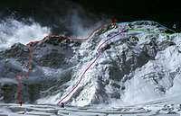
Base Camp and Climbin 2018 the camp leader Dimitri and his friend Alex were very unfriendly and had lots of discussions with several customers. People with 'Full Package' were not satisfied with the food and they were hungry every evening. As i tried 2 different routes (Abalakov 2018, Classic 2017 to 6600m), i 'd suggest to go with the Abalakov route. To me the Abalakov seems to be much safer than the Classic route where you have to climb through a very dangerous ceracs section and a rock part with very rotten fixed ropes. The snow can be a problem on both routes. The Abalakov has lots of crevasses in the lover part and some cornices at around 5500m where you have to take care not to break through. I added a picture (shot 2018 from Ak-Tau Clol) with an overview of the north face and the routes drawn.
runout - Dec 14, 2023 11:12 am - Voted 9/10
True summit surveyhttps://www.countryhighpoints.com/the-true-summit-location-of-peak-pobeda/