
|
|
Area/Range |
|---|---|
|
|
47.57421°N / 15.79002°E |
|
|
Hiking, Sport Climbing, Via Ferrata, Skiing |
|
|
Spring, Summer, Fall, Winter |
|
|
5846 ft / 1782 m |
|
|
The Purpose of This Page
This page is the attempt to complete the ranges of the Eastern Alps => I am looking for images (and also information) of Wechsel, Leithagebirge, Rosaliagebirge etc. to improve the page...Overview
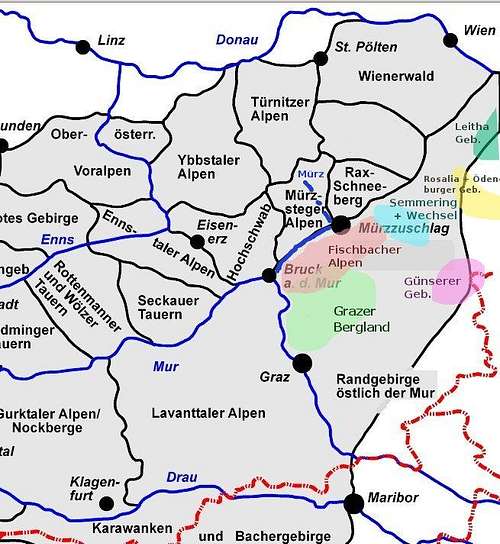
The Mountains east of the Mura are part of the Central Eastern Alps and consist of mountains and ranges eastwards the rivers Mura (Mur), Mürz and Semmering Pass - the exact borders are mentioned in sector Range Boundaries.A small part of the subranges Günserer Berge (Kőszegi-hegység) and Ödenburger Gebirge (Soproni-hegység) are in Hungary.
subranges/areas
The most important subranges/areas are:
- Grazer Bergland
- Fischbacher Alpen - with the highest moutain: Stuhleck
- Semmering Pass
- Wechsel
- Bucklige Welt
- Rosaliagebirge
- Leithagebirge
- Günser Gebirge or Günser Bergland
- Ödenburger Gebirge
Subranges and Subareas of Mountains east of the Mur (Mura)
Due to the hilly character of all subareas Hiking (on often well marked trails) is the most important alpine activity. Climbing Areas and Sking Resorts (also Ski Randonee) are in Grazer Bergland and Fischbacher Alpen - also Semmering and Wechsel.
Range Boundaries
The rivers Mur (up to Bruck an der Mur) and the river Mürz (to Mürzzuschlag) are the westward/northern borders of the Randgebirge östlich der Mur - continuing via Semmering and Gloggnitz to the Vienna Basin (Wiener Becken) to Bruck an der Leitha via Lake Neusiedl (Neusiedler See) to the Pannonian Basin (Pannonisches Becken) back to the river Mur.
Getting There
Important junctions are Vienna and Graz. Detailed information will be mentioned in each subarea sectionsCamping + Places to Stay
All subareas and surrounding valleys are (more or less) well developed for tourism. You can stay there in many hotels, B+Bs and camping places. Meanwhile the covaerage with moutain huts is quite poor. In the low season it might be difficult to find a place to stay at reasonable costs.Red Tape
-Grazer Bergland
Grazer Bergland is famous for good climbing routes - more information is available at the Grazer Bergland page Route Feuervogel - Rote Wand
 | 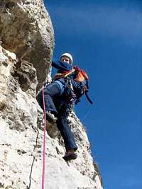 Elfengarten - Röthelstein
 |  UFO - Röthelstein
 |
|---|
Fischbacher Alpen - Stuhleck
A mountain range southward and parallel the river Mürz, that is mainly wooded and alpine pasture.Small ski resorts are characteristic in the Fischerbacher Alps. Also near the highest moutain: Stuhleck is a small ski resort
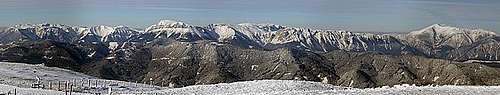
Panoramic view from Stuhleck summit
 Kaltenbachgraben
 |  View from Stuhleck summit
 |  Ascending Stuhleck
 |  Ascending Stuhleck from Rettenegg
 |
|---|---|---|---|
 Stuhleck Summit
 |  Stuhleck - Steinkorb
 |  Steinkorb - Stuhleck
 |
Peter Rosegger is a famous poet - born in Alpl (a small town in the Fischbacher Alps)
Getting There
Fischbacher Alpen are reached via A2 Südautobahn and S6 (Semmering Schnellstrße - Semmering Highway). Mürzzuschlag, Spital am Semmering and other towns in Mürztal are near the Austrian southern Railway.
Links + Webcams:
Wintersportsmuseum in Mürzzuschlag
Webcam St. Kathrein am Hauenstein
Spital am Semmering (also maps available)
Ski Resort Stuhleck
Ski Resort Skiregion Joglland
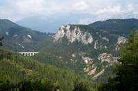
Semmering Pass
Actually not a range or mountain - but an important connection between Styria and Lower Austria (nowadays crossed by road, highway and train).Semmering Railway
The Semmering Railway was the first standard gauge track mountain railway built in Europe (built between 1848 - 1854).In 1998 the Semmering Railway was added to the list of the UNESCO World Heritage sites.
The travel experience that the Semmering Railway offered (and still offers) was in significant contribution to the development of tourism in the Semmering region in the 19th century.
 Semmering Railway
 | 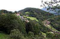 Semmering Railway
 |
|---|
Links + Webcams:
Semmering Railway (UNESCO)
Semmering Railway (numerous images)
Ski Resort Semmering
Wechsel
Wechsel Pass is an important connection between Styria and Lower Austria - nowadays crossed by the Südautobahn A2 but also a moutain - with small ski resorts in Styria and Lower Austria. In summer and fall the hiking trails over alpine pastures are well attended and offer a great panoramic views. Wechsel
 |
|---|
Main Summit: Hochwechsel 1.743m
Wetterkoglerhaus near the summit (closed in winter) -
Geology: Skate and Gneiss (Wechselschiefer and Wechselgneis)
Links + Webcams
St. Corona am Wechsel
Mönichkirchen
Kirchberg am Wechsel
St. Corona am Wechsel Webcam
Mariensee (Wechsel) Webcam
Mönichkirchen (Wechsel) Webcam
Bucklige Welt
Bucklige Welt is hilly area bordered by Semmering (West) and Wechsel (South) and Rosalia Gebirge (East). The northern border of Bucklige Welt flattens into the Vienna Basin (Wiener Becken). Bucklige Welt
 |  Sport Climbing
 |
|---|
The roads and trails (where permitted) are popular biking and mountain biking destinations.
Mostheurige (cider or must made of apples and pears) are charactaristic for Bucklige Welt.
A short via ferrata Pittentaler Klettersteig on Türkensturz is near Gleißenfeld (Neunkirchen and Wiener Neustadt are the nearest bigger towns)
Links + Webcams
www.buckligewelt.at
Mostheurige in Bucklige Welt
Pittentaler Klettersteig - Türkensturz
Rosaliengebirge
Rosaliengebirge offers nice and easy hikes (might be interesting for mountain bikers).I did some short hikes there in March 2016.
 Rosalienkapelle
 |  Teufelsschlössl
 |
|---|
Subranges to be added
LeithagebirgeGünser Gebirge or Günser Bergland (Kőszegi-hegység)
Ödenburger Gebirge (Soproni-hegység)