Bear Peak
From South Mesa TH
Sunday August 11, 2013
Sunday morning after sleeping-in until 7:30am I was greeted with beautiful weather and a clean slate schedule-wise. Had a lazy breakfast, read the paper and finally had the notion to get out and decided to do something close to home. South Mesa TH being less than ten miles from my front door sounded like the plan. I readied my gear and was on the road quite quickly. Drove through Louisville and was out of Superior on route 170 to Marshall, then across route 93 and up to the South Mesa TH where I lucked-out and grabbed a spot to park where another was just leaving. Nice! South Mesa has a somewhat unusual parking system; if you live in Boulder County (which I do) then the parking is free, if not; then the fee is $5. I wasted little time and was on the trail right at 10:20am.
My early morning lazy ways had me on a very late start by my standards and although I didn’t really know the way I checked the TH board and chose to ascend up the Towhee Trail. I spoke to a younger couple about Bear Peak and was told that the trail went up to where there was fire damage from the Flagstaff Fire of 2012 and then was closed to Bear Peak. My heart sunk a bit but I figured may as well give-it-a-go and see where this day takes me. The Towhee Trail climbed steadily until merging with the Homestead Trail where it bears right and continues on as the Shadow Canyon Trail. I didn’t see another soul this entire way and after a while the Shadow Canyon Trail then met with the road-like Mesa Trail where I went left and continued to climb up with lots of other people now going my way.
I passed first one abandoned house on the left and then after a brief while I came to another abandoned house on the right and here the road stops and a single track trail breaks slightly to the left and up I went through much more heavy forest as the trail grew markedly steeper. The day was rather warm and the humidity was noticeably high as the trail became much more of a challenge with large boulders and giant evergreen trees. The trail showed signs of heavy rains from the night before and avoiding the many fast drying puddles and finding the correct path had me following two other people. I noted that the trail is quite clearly marked with red darts and an occasional green one here and there. After a good while of following along behind the guy and gal ahead we all stopped and spoke with two guys coming down. They informed us that Bear Peak was about another hour and the trail got much more difficult the farther you went.
I was glad to now hear that the trail was not closed ahead and up I went passing the guy and gal as they turned back down because they hadn’t brought any water with them. Not sure what they were expecting up here but not bringing water is a big mistake no matter where you go hiking in my opinion. I would not see another person for a good while as I climbed the winding, rocky, washed-out trail ever higher and staying hydrated was job one as I was really sweating-along with every step and the countless rock steps and switchbacks brought me higher where I now saw a person every now and again heading down. I stopped often for a brief rest and more water and could now hear voices following me below. Not sure just why, but hearing the voices somehow spurred me on as I found myself not wanting to get passed for whatever reason and this helped me stay the course and keep my steady pace.
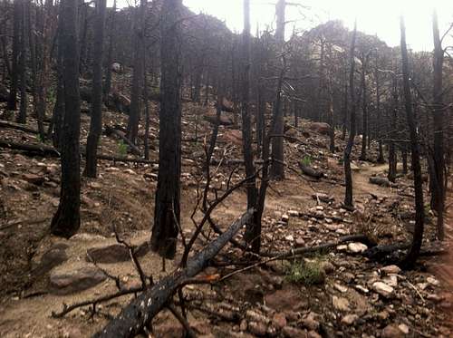
I hadn’t really done any “homework” for this hike and found it to be a bit more of an effort than I had thought with the trail climbing steadily with every step and the warm day taking its toll I found I had to stop ever frequently and take a short blow and more water and was glad I’d brought a full 3 liters with me. I was now reaching some longer switchbacks and the trail leveled –out to a much more gradual ascent as I now came to where the conflagration from the year before showed the burned-out remains. However, solid efforts had obviously been taken here as giant downed trees had been cut and moved aside to allow the trail to be open; I now noticed sooty residue most everywhere and my hands became black from grabbing rocks as I went.
I was taken-back by the completeness of the burn, where there once was a great forest was now blackened with only some grasses and small flowers refusing to submit and making all efforts to renew if only the ground cover.
![Charred Trail]() Charred Trail
Charred Trail
It was now to be generations before this area would be but a shadow of what it once was and the shade from below gave way to a hazy sunshine that made things warmer still; although a cooling breeze from time to time helped things from being stagnant in this barren section where I could now see people behind me coming up to where I now found the saddle/ juncture between South Boulder Peak and Bear Peak.
I now turned right and headed for Bear Peak as the views were now coming into view of the eastern plains below and the trail continued through the burned area up and around the left side of a heavily bouldered section, down a bit and then up to a junction with Fern Trail where I found others now coming up from that way and then on up and around right to the actual connecting ridge to the summit of Bear Peak. Here I could now see a short, rocky approach across rock that was the color of a Hershey bar brown and worn smooth by countless others having crossed this section for many years before.
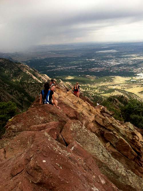
![Bear Peak Summit Ridge]() Crowded Summit Ridge
Crowded Summit Ridge
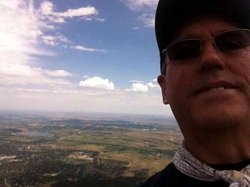
I clambered across on all fours and made my way around lots of people sitting on their own space of the summit; I moved ahead to the very highest point to claim the true summit and found a tight spot to call my own at 12:26pm. I’d made it!
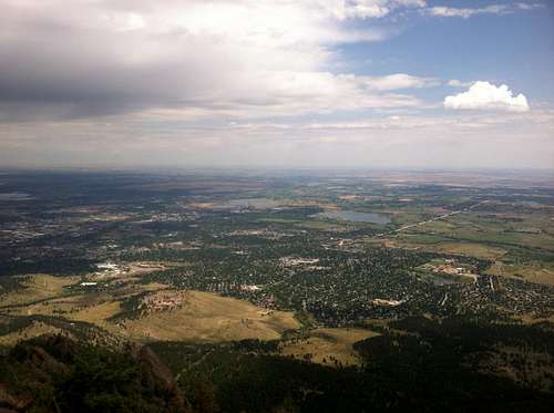
I removed my pack and pulled some trail mix and gulped-down a couple of handfuls with water as a chaser and then made my way to the summit registry and signed-in. There had to be 20 people on this tiny summit all finding their one little space to occupy while enjoying the impressive views in all directions. A nice breeze cooled things some as I pulled my cell phone and started taking many photos of the surrounding scenery. Boulder and NCAR dominated the views directly below
![Boulder Down Below]() Boulder, Colorado
Boulder, Colorado
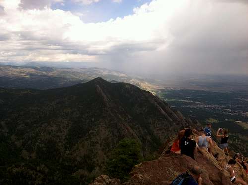
and out east was route 36 and Baseline Road running straight toward a distant Denver and out to the great high plains beyond. I snapped pictures in all directions
![Green Mt and Flatirons]() Gather Crowd, Flatirons in the background
Gather Crowd, Flatirons in the background
and took in more food and water while taking a breather, removing the pebbles from my boots and then pulling myself back together in preparation for my exit as many more people were now arriving.
![Bear Peak Summit Shot]() Summit Shot
Summit Shot
I took my customary three aspirin, loaded-up and started back down across the ridge at 12:46.
Once I cleared the ridge I found myself heading down the wrong direction and soon back-tracked some until I was back on the trail back down to the saddle and through the burned area. I wasted no time and was glad to get back into the shade of the forest for my descent back down the way I’d come. Distant thunder was now approaching from the west and the clouds were starting to build overhead making things noticeably darker as I wouldn’t make many stops along the way as it seemed as though it may start storming any minute. I would see many others now coming up as I continued down and the rocky trail heeded my utmost attention as a stumble or fall on this trail would result in a twisted ankle or worse. A few rain drops now fell and I really wanted to clear this steep, rocky trail and get back down to the Mesa Trail before heavy weather moved in; thus, I would not stop until getting through the single trail and the abandoned house other than to take a few pix along the way.
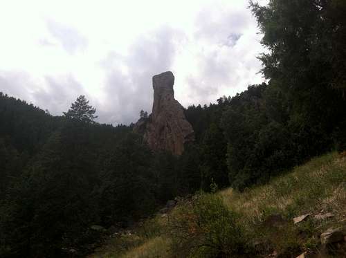
![Devils Thumb]() Devils Thumb
Devils Thumb
Back down the road of the Mesa Trail went uneventfully and the heavy weather never materialized as the clouds made way to partly sunny skies and the way back down was somewhat of a grind with lots more people going in both directions.
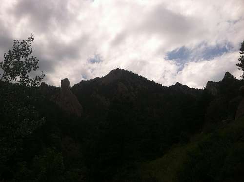
![Devils Thumb & Bear Peak]() Devils Thumb & Bear Peak
Devils Thumb & Bear Peak
One last push down passed the stone Dunn House from 1872, back across South Boulder Creek Bridge, the parking lot and back to my truck at 2:29pm. Not sure why I’d waited so long to hike this area that lies in my own back yard but I was glad to have this day and the rewards of making the effort to get out into the Front Range of Boulder County. As the old adage goes, “there’s no place like home”……….Way sweet!!
I’d received a text message on my phone to stop at a friend’s pool on the way home and did just that for much welcomed relief from the heat and humidity. Nice way to round-out a fine day.
Comments
No comments posted yet.