The Long and Winding Road (to get to the TH)
North Emmons Peak (13,068’) & Roberts Peak (13,287’)
To have a goal is to have a purpose. And my purposeful goal was to climb all twenty – some say there are 21 - of Utah’s Thirteeners. The Utah state highpoint, Kings Peak, was the first Thirteener to receive a simple checkmark in the box preceding its name on the list. That date was September 17th, 2004. As fate would have it, the following years, with the exception of 2007 and 2012, found me topping out on at least one of them so that 2013 arrived with me still having 5 unchecked boxes, small square-cornered reminders that achieving my goal would take more than good intentions or wishful thinking.
You may read about the first ones to fall this year in my trip report titled “The Northern Four (5).” The results of that 19-hour adventure left me with two un-conquered peaks, the two mentioned in the title of this narration. As soon as I had climbed Painter Peak and Trail Rider Peak, along with the questionable 13,306 bump, I knew that this year was going to be the culmination of nearly 9 years’ effort. Much to my dismay, I no sooner began planning for N Emmons and Roberts than the weather turned moody and often downright cantankerous. A dogged pattern of low- and high-pressure systems funneled moisture from the National Parks of southern Utah northward triggering showers and thunderstorms which pounded the Uintas nearly every afternoon for several weeks.
Time was running out; days were getting shorter, and in the Uintas, at least for me, daylight is a precious commodity never to be discounted. I would no sooner make plans for the one-day push from the Swift Creek trailhead than the forecast would change from 0% chance of rain to 30% chance of showers and afternoon thunderstorms. No one in his or her right mind would head into the High Uintas with that kind of ominous forecast.
Then a gradual change took place, a small one but one which offered me a solid chance for at least good weather for half of a day. My usual hiking partner would be unable to go, so I decided to leave early in the morning for the Swift Creek trailhead and hike in as far as Deer Lake; by so doing I could familiarize myself with the portions of the trail I might later have to ply in the darkness.
The drive to the Swift Creek trailhead from Salt Lake City takes approximately three hours according to reports I had in hand. The drive to Duchesne, Utah, is quick via I-80 and route 40. Fifteen miles north of Duchesne one encounters stretches of road rougher than petrified corn cobs. The final four miles offer better gravel on better dirt; the Swift Creek trailhead is the end of the line for the route.
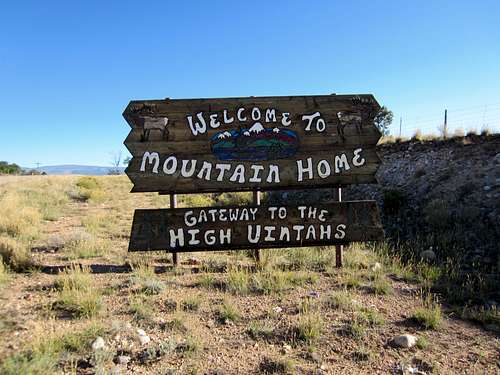
![Roberts Peak]() About 16 miles north of Duchesne you should see this sign en route to the Swift Creek TH. In the context, the word "Uintahs" is misspelled; it should read "Uintas."
About 16 miles north of Duchesne you should see this sign en route to the Swift Creek TH. In the context, the word "Uintahs" is misspelled; it should read "Uintas."
En route to Duchesne I witnessed thunderstorms further darkening the pre-dawn skies, black masses with violent bursts of lightning tracing jagged yellow scars through the inky void. I thought for sure I’d never make any kind of a hike, and I wondered if the rains might have washed out portions of the dirt road I’d be travelling over. Yet by the time I arrived at the trailhead the dark clouds and rain had moved further to the northeast, sunshine was attempting to peek through breaks in the thinning clouds and it looked like a pleasant day was now in store for my exploratory hike.
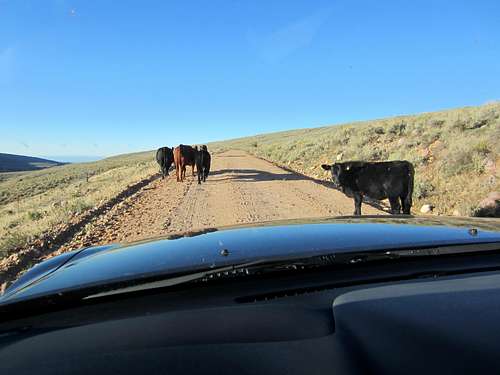
![Roberts Peak]() When the signs say Open Range beware of moving obstacles on the roads! Or sometimes the obstacles don't seem to move at all, exhibiting only nonchalance and mild curiosity.
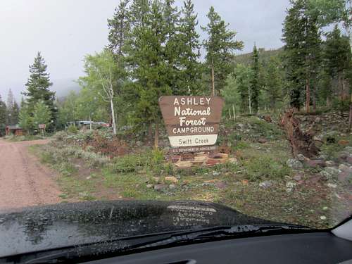
When the signs say Open Range beware of moving obstacles on the roads! Or sometimes the obstacles don't seem to move at all, exhibiting only nonchalance and mild curiosity.![Roberts Peak]() After nearly 25 miles of sometimes rough road out of Duchesne I was happy to see the official sign for the Swift Creek TH. Potable water and clean restrooms make this a nice destination from which to launch a hike.
After nearly 25 miles of sometimes rough road out of Duchesne I was happy to see the official sign for the Swift Creek TH. Potable water and clean restrooms make this a nice destination from which to launch a hike.
Familiarity breeds contentment: An exploratory hike to Deer Lake
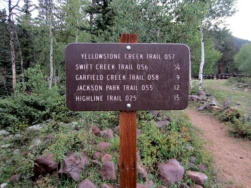
![Roberts Peak]() I don't know about you, but I really like signs like this at the TH.
I don't know about you, but I really like signs like this at the TH.
Starting out a little before nine o’clock, morning sunshine now my partner, I left the sign board at the well-marked trailhead and worked my way up the trail, taking note of signs, switchbacks, views and possible landmarks I might have use for the “big” attempt somewhere in the future.
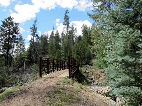
![Roberts Peak]() Wouldn't it be nice to have a bridge like this at all of the crossings? This nifty structure rests about 5 minutes from the Swift Creek trailhead.
Wouldn't it be nice to have a bridge like this at all of the crossings? This nifty structure rests about 5 minutes from the Swift Creek trailhead.
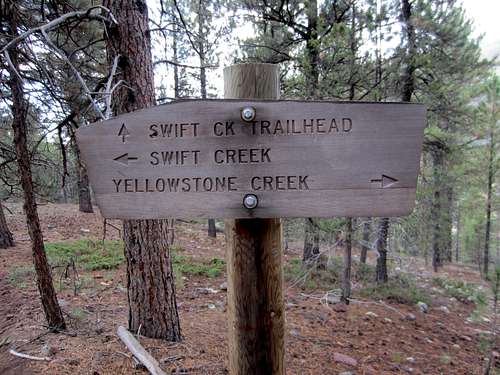
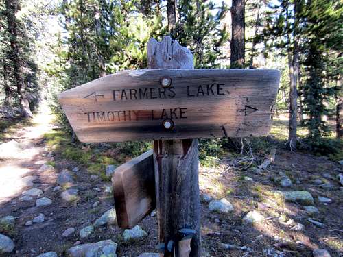
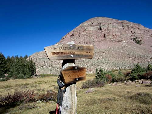
![Roberts Peak]() After crossing the Swift Creek on a sturdy bridge you encounter this sign, a clear indication of two different trails. The Swift Creek trail leads to the Timothy Lakes basin.
After crossing the Swift Creek on a sturdy bridge you encounter this sign, a clear indication of two different trails. The Swift Creek trail leads to the Timothy Lakes basin.
At the first stream crossing I tried to bushwhack, following the route which ZeeJay had taken to avoid the first and second stream crossings. I found it mostly frustrating and had to make many back-and-forth adjustments until I finally re-intercepted the trail above the 2nd crossing.
From there it was maybe 25 minutes to Deer Lake, a picturesque little setting for postcards and travelogues, should one have the inclination to use it for that purpose.
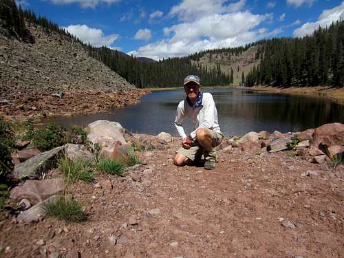
![Roberts Peak]() Although small, Deer Lake is certainly picturesque and offers a pleasant spot for taking a well-deserved break. East Timothy Lake is a mere three miles further.
Although small, Deer Lake is certainly picturesque and offers a pleasant spot for taking a well-deserved break. East Timothy Lake is a mere three miles further.
A short break was all I needed before returning via the regular trail; I wanted to see what the stream crossings would be like and I had no stomach for attempting to bushwhack back down.
I found the first crossing to be manageable and stayed dry in so doing. There was a long tree-trunk pole lying across the stream, most of which was exposed and dry. Using this pole along with the boulders holding it in place against the stream’s current I crossed the stream, a human sloth slinking along a tree branch. Most of the time I was grasping the pole with both hands and balancing my feet as I placed them carefully atop one boulder tip after another. A slip would have been disastrous, but I was fortunate and found myself across and dry after 45 seconds of fear and trembling. I thought, “The water level next time might be even lower than today, so that serendipitous pole will help me take care of this crossing perfectly.” How wrong that assumption would prove to be.
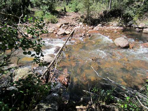
![Roberts Peak]() This de-limbed tree trunk provided me dry passage across the Swift Creek tributary on my return from Deer Lake. But if the water levels were to rise for the "big" attempt at Roberts, it would probably do me little good. They rose...
This de-limbed tree trunk provided me dry passage across the Swift Creek tributary on my return from Deer Lake. But if the water levels were to rise for the "big" attempt at Roberts, it would probably do me little good. They rose...
The final crossing, the one I would encounter first on the hike in, was more problematic, and I ended up searching around until I found the spot where I would get the least wet as I dipped down into the stream with boots on. Four quick steps after 4 slippery boulders and I was across, my gaiters having kept my boots from becoming soaked. Wow, was that water cold. I decided right then and there that my “real” trip would find me crossing the stream utilizing my neoprene booties, the ones I had purchased for Aconcagua river crossings several years earlier. There would be no bushwhacking on my attempt for Roberts and North Emmons.
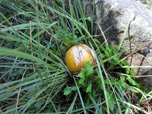
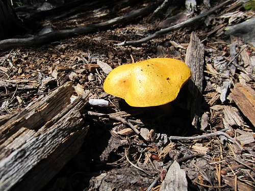
![Roberts Peak]() There are myriad fungi along the Swift Creek trail.
There are myriad fungi along the Swift Creek trail.![Roberts Peak]() Another example of Mother Nature's endless variety.
Another example of Mother Nature's endless variety.
Before driving home I inspected the campground and checked to see if there really was potable water available there. Yes, and that along with clean bathrooms and picnic tables at every one of the dozen campsites. This exploratory hike took place on September 5th, and the old weather patterns immediately resumed their seemingly appointed task of hammering the Uintas with heavy rains and murderous thunderstorms. After two weeks of waiting, another break in the weather routine emerged, but it turned out that I was no longer going to have a hiking partner with me because of schedule conflicts. If I was going to take advantage of the weather window I would have to do it solo.
The whole enchilada - the beginning of my 40-hour adventure
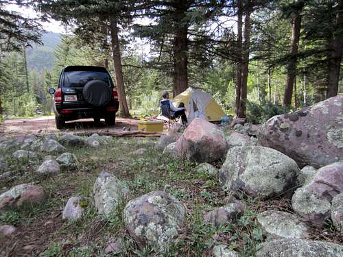
![Roberts Peak]() Alone in the solitude of the Swift Creek CG. I would get used to being solo for the next 40 hours or so. Not the way I planned, but that's the way it played out.
Alone in the solitude of the Swift Creek CG. I would get used to being solo for the next 40 hours or so. Not the way I planned, but that's the way it played out.
I drove to the trailhead on the 18th of September and set up my camp in site number eight. The sunny day was breezy but the temperatures were mild. Swift Creek was running higher than I remembered from my earlier trip, and I wondered out loud what difference it might be making at the stream crossings. I would find out the next day. I signed the trail register in advance; it was housed in a metal container next to the trailhead information board. I saw only empty horse trailers and no humans in or around the campground. Sleeping was fitful as I was excited about getting up at 4 a.m. in preparation for a planned 5 o’clock departure. The only sounds I heard were those of the swaying tree branches and the relentless tumbling and rushing of Swift Creek a couple hundred yards to my north. The moon would be full tomorrow night, but tonight it was so brilliant one could have easily called it a full moon and everyone would have been a believer.
Four in the morning, the bright moon slowly drifting toward the western hilltops but still at about a 15° angle. Its silky light threw sharply defined shadows eastward, and my GPS alarm feature sounded its eerie fluttering high-pitched trilling to gently prod me out of my warm sleeping bag and out into the 34° morning air. Now, I don’t mind getting tough when the going becomes tough, but here, in the camp, next to my ready-and-waiting Montero? I hurriedly fixed my pre-mixed cereal concoction by adding yogurt and almond milk, and I slipped into the car behind the steering wheel and started the motor. I wanted to eat in the warmth of the car, and since there wasn’t a soul in the campground besides me I wasn’t going to be disturbing anyone’s shuteye by cranking the engine. Ah, that was nice, feeling the warm air flowing through the distribution vents, soothing my very cold fingers.
Way too soon it was time to go: places to go, streams to cross, trails to follow, mountains to climb. Swift Creek trailhead elevation is about 8,100’. My two peaks were both over 13,000’, so simple math means that the elevation gain was certainly going to exceed 5,000’, and that would be a starting estimate. The saddle between N Emmons and Roberts was near 12,500’, so there is another 500’; trail undulations could easily tack on another 300’ or 400’. The distance to East Timothy Lake was pegged at nine miles, and the peaks were about two miles further. ZeeJay had written that her similar trip was 24 miles. So I had a strenuous day ahead of me no matter how I sliced it. It all boiled down to a simple adage: get going, buddy; you do wish to return before midnight, don’t you?
Darkness, stream crossings and North Emmons
My trusted Petzl headlamp beam pierced the early morning darkness as I headed up the road toward the actual trailhead, startling two deer whose eyes glowed in ghostly fashion as they spied me and then beat a quick retreat. Past the silent horse trailers, past the trailhead signboard and into the forest of lodge pole pines I walked, knowing where the initial path led. After a few minutes I was crossing the near deafening creek on that wonderfully-engineered steel/wooden bridge and tackling the first segment of the hike. After two more minutes I came to the trail split and began the seven switchbacks which would lead me to the ridge above, a narrow affair separating the Yellowstone drainage from the Swift Creek drainage.
My power breakfast working its miracles, I felt strong climbing the switchbacks and moving swiftly along the narrow ridge. Time went by quickly and I was at the first stream crossing as the dawn allowed me to turn off my headlamp. Just before reaching the crossing I heard a scampering sound off to my right and a splashing in the adjacent beaver pond. Then I saw very plainly the head of the beaver making a slight wake as it swam quickly away from my position. Very cool!
At the crossing point I sat down on the frost-laden grass and changed into my ankle-high neoprene booties. With my Zamberlan hiking boots carefully and tightly tied together and draped around my neck like a winter scarf I carefully picked my way across, thankful for the trekking poles which gave me two comforting additional points of balance. The water stung my calves and knees as I waded deliberately through the fast-moving water. The other side didn’t come fast enough, but it came. I sloshed along several side rivulets and across a boggy area before finding the resumption of the dry trail. Then it was another wardrobe change, this one the reverse of the first, and I gingerly dried my deadened feet, hoping that circulation would return with a vengeance. Stuffing my wet booties into a plastic bag and then into my pack, I resumed the hike, knowing full well that another costume change awaited me twenty minutes later. That’s life for this trail.
![Roberts Peak]() After successfully completing the first stream crossing I had this view as I changed back into my hiking boots and emptied my neoprene booties.
After successfully completing the first stream crossing I had this view as I changed back into my hiking boots and emptied my neoprene booties.
![Roberts Peak]() A captivating view of Swift Creek after leaving Deer Lake.
A captivating view of Swift Creek after leaving Deer Lake.
Climbing parallel to but up and high above Swift Creek the trail continued through lodge pole pine forest until another confluence of trail and stream. It was this stream which I was able to cross without getting wet 10 days earlier. I recognized the thin barkless tree trunk lying at a 90° angle to the stream. On my exploratory hike this makeshift lifeline touched both stream sides. Now, with heightened water levels, the pole didn’t quite touch either shore and water had submerged the once dry pole to a depth of 4” or 5”. It was immediately obvious to me that a costume change would be imperative on both crossings here.
So I did, and the water was even deeper than it had been at the first crossing. Safely across I quickly changed back into my boots and began the short climb and descent to Deer Lake (10,200’). This section of trail climbs quickly away from the stream and takes one high above Deer Lake, necessitating a rather long descent back down to the scenic lake with large boulders defining the west bank. Elapsed time: 3+16. It was time for a break, and I mulled over the idea of leaving my booties here since there would not be any more stream crossings until my return. In the end my conservatism ruled and I stuffed the booties back in my pack - just in case. As it turned out, I could have deposited them there and carried a lighter burden for the following twelve hours. So the booties became useless ballast until my twilight return to the aforementioned 2nd crossing. Live and learn?
![Roberts Peak]() At about the 4-hour point this sign provides a modicum of reassurance that you are heading in the right direction. There is another sign of similar nature near what's called Farmer's Point.
At about the 4-hour point this sign provides a modicum of reassurance that you are heading in the right direction. There is another sign of similar nature near what's called Farmer's Point.
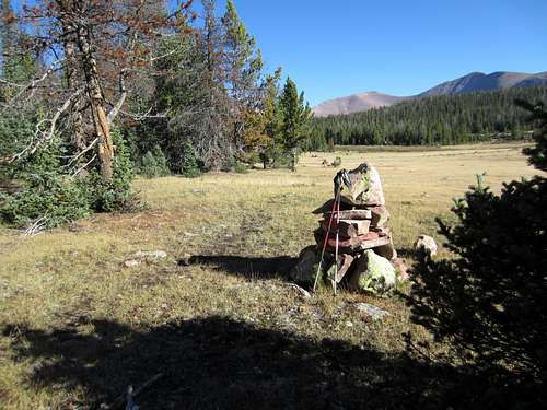
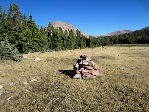
![Roberts Peak]() Supercairns like these help one find the way across two different meadows en route to East Timothy Lake. Thanks to the builders, whoever they are!
Supercairns like these help one find the way across two different meadows en route to East Timothy Lake. Thanks to the builders, whoever they are!
![Roberts Peak]() Farmer's Point (named by author David Rose in "Utah Thirteeners") is straight ahead. I found a pair of sunglasses on the ground next to this supercairn. If they are yours, send me a private email and we can arrange a joyful reunion! :)
Farmer's Point (named by author David Rose in "Utah Thirteeners") is straight ahead. I found a pair of sunglasses on the ground next to this supercairn. If they are yours, send me a private email and we can arrange a joyful reunion! :)
The next section of the trail, as described in the books, led through forest and across the western edge of two spacious meadows. There were warnings about it being easy to lose one’s way at two junctions and across the meadows. It turned out that there were easy-to-read signs at the junctions and man-sized cairns marking the correct way through the meadows. Wow, what a pleasant set of surprises. And this made the leg leading to East Timothy Lake only daunting in some of the forest areas where the trail often became faint. Wherever I found myself wondering aloud where the trail was I placed a small cairn to assist me on my return.
![Roberts Peak]() After about 4+30 on the trail this helpful sign points one in the proper direction.
After about 4+30 on the trail this helpful sign points one in the proper direction.
The hike to East Timothy Lake took me until 10:05. Near 11,000’ now, I crossed the outlet stream from the lake as I headed east toward the base of the Kings-Emmons ridge where I would begin a rather steep climb up to a broad saddle cradled between Roberts and N Emmons Peak. Looking up at the long ridge of 13ers I chuckled as I stood in awe of them. At once they seemed homogenous, bumps very much alike in shape. Perspective does make a difference; it would be nearly impossible to make this trip in white-out conditions or even in foggy weather. Between my position near E Timothy Lake and the base of the ridge I passed through two stands of forest where there was no trail. The bushwhacking was mild and soon enough I was examining the climbing conditions for the ascent. They appeared to be less-than-desirable with few large boulders and large sections of small talus interrupted by patches of tundra. And all of it was steep with a capital S.
Figuratively shrugging my shoulders I began the slog and hunted for the few large rock outcroppings where I could find some relief from the loose talus and aggravating scree. One hour of this unpleasant activity found me more or less at the sprawling and gentle saddle resting lazily at about 12,500’. A small cloud of doubt sailed through my mind regarding my exact whereabouts, so I checked my GPS and discovered with subdued delight that I was almost exactly where ZeeJay had been when she did a similar trip several years earlier. N Emmons looked a long way off, but there was no hesitancy in starting that portion of the trek.
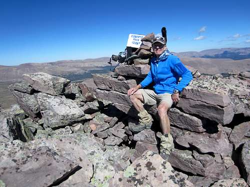
Seas of boulders; waves of boulders; ripples of even bolder boulders; false summits; increasingly stronger breezes; boulders like the sands of an ocean shore; breezes transforming themselves into grown-up winds. Slogging in the true sense of the word. But I saw what I at last knew must be the summit, and shortly thereafter the pyramidal shape of a small cairn nosed its way into the air. Forty-five minutes of perseverance had brought me to the summit of N Emmons (13,068’). And I’ll admit it: I was just a bit tired. Elapsed time: 7+44. One down, one to go! As I pulled on my blue Marmot fleece, my favorite light jacket for the conditions up there, I began calculating how I was doing with time management.
![Roberts Peak]() It took me nearly 8 hours but I reached the summit of North Emmons without injury. A bluebird day for long-range views. Generally light winds and temps in the high 40s made the lofty summit more than tolerable.
It took me nearly 8 hours but I reached the summit of North Emmons without injury. A bluebird day for long-range views. Generally light winds and temps in the high 40s made the lofty summit more than tolerable.
My goal regarding my return was to make at least one of the stream crossings below Deer Lake before dark. It was now one o’clock. Let’s see now – at least one hour to Roberts, maybe two; one and a half hours down and back to E Timothy Lake. That’s 4:30; another hour and a half to Deer Lake…that’s six o’clock. Sunset is about 7:30, so that would work wonderfully. But I was familiar with my rose-colored glasses estimates, so I added another hour for being tired and trudging across the vast interior of the Timothy Lakes Basin. It would still work, but I had to get going; I did not have the luxury of spending much time at either summit.
![Roberts Peak]() Because of this fascinating pinnacle just south of the summit, North Emmons is sometimes called "Pinnacle Peak." The massive mound in the background is the northern slope of Mount Emmons.
Because of this fascinating pinnacle just south of the summit, North Emmons is sometimes called "Pinnacle Peak." The massive mound in the background is the northern slope of Mount Emmons.
I snapped a picture of a curious and precarious pinnacle, standing like a NASA rocket awaiting launch. This delicately balanced stalagmite-like formation protrudes heavenward north of and below the N Emmons summit. Satisfied with my short summit stay I set out to re-trace, so to speak, my steps back to the saddle and then ascend the nearly 800 feet of mountain which should place me square on the Roberts Peak summit. Gazing to the north at my goal I realized that this was not going to be a stroll in the park. And the bump before Roberts Peak looked like a giant dirty snow cone with the emphasis on “giant.”
Roberts Peak, here I come - And an arduous descent therefrom!
Twenty-five minutes back to the saddle area. Start up; I’d engaged in this activity before and knew exactly what to expect. On this ascent there were, however, many more unbalanced boulders than along the route to N Emmons. Great – just what my tiring legs needed! There was the bump, or was it? Nope, there it was. Above me. As I marched across the very short level area just beyond the bump I checked my GPS and found a reading of 13,001’. Hmmm. I was doing the math and attempting to chase away tedium by playing the game of finding the biggest boulders I could jump to without putting my life in jeopardy. And suddenly, there it was: a block upon which a modest cairn waited for worship by adoring hikers elated to have found this place. Quiet jubilation – two down, a return to go! Elapsed time: 9+29; time from N Emmons to Roberts: 1+25. My estimate of time required to get there from N Emmons was about right; my timetable for the return was still intact. But I couldn’t spend much time relaxing or patting myself on the back – there were many more important things to do.
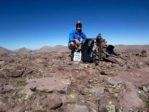
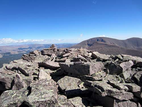
![Roberts Peak]() About 2:45 p.m. I am finally atop Roberts Peak, thus completing my goal of topping out on all of Utah's 13ers. Now all I had to do was return to the trailhead without killing myself. :)
About 2:45 p.m. I am finally atop Roberts Peak, thus completing my goal of topping out on all of Utah's 13ers. Now all I had to do was return to the trailhead without killing myself. :)
I retrieved a plastic mayonnaise jar from my pack and placed it securely at the base of the cairn. Hah, there was a plastic spice container already there. Well, now there would be two summit registers. After signing the little scrap of paper inside the spice bottle, I returned it to its rabbit hole. I had pre-signed the register paper which I had carried up, so I placed the newer summit register close to the older smaller one and anchored it with several fist-sized rocks. I took a few steps away from the summit block and took in the vastness of the Uintas, taking a few pictures of the daunting Kings-Emmons Ridge. Then more time calculations; I had to get going. “Goodbye, old friend, the last of the 13er summits. Take care and give my regards to the next hikers to visit here. Hate to eat and run, but time and twilight wait for no man.”
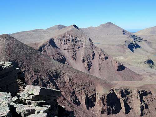
![Roberts Peak]() Take a few steps north of the summit cairn and your view to the south includes North Emmons, Emmons and South Emmons.
Take a few steps north of the summit cairn and your view to the south includes North Emmons, Emmons and South Emmons.
![Roberts Peak]() From the Roberts Peak summit one can look north and easily spot Trail Rider, Painter, South Kings and Kings Peaks.
From the Roberts Peak summit one can look north and easily spot Trail Rider, Painter, South Kings and Kings Peaks.![Roberts Peak]() From the summit of Roberts Peak, again looking north, one spots three more prominent Uinta 13ers: West Gunsight, Gunsight and Gilbert Peaks.
From the summit of Roberts Peak, again looking north, one spots three more prominent Uinta 13ers: West Gunsight, Gunsight and Gilbert Peaks.
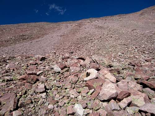
I took off down the rough-and-tumble rocks and jumbled boulders leading north. Dropping off the rugged ridge to avoid a section of ten-foot-high pinnacles I looked down into the basin, got the lay of the land, saw my goal waaay over by E Timothy Lake and made a decision I would regret for the next excruciatingly long hour of descent: I will drop down here instead of waiting. I thought it looked “okay.” Wrong again, but by the time I figured that out, it was too late to do anything but bite the proverbial bullet and get down any way I could without terminating my life.
It was steep. It was slippery. Gravel skiing became the sport-of-choice at certain junctures. Holding my breath became the norm. Grunting out loud was quickly okayed. Short breaks were soon a necessity, not a luxury. I longed for the stable and large boulders like those on the east flank of Kings Peak. But I would not find them here. It was simply an hour of self-inflicted agony punctuated with the mild heartbreak of the bottom eerily moving ever further away from my halting steps. Once down I shouted out for joy and to relieve pent up frustration at the poor decision. I suppose I could have blamed it on fatigue or the overwhelming desire to cut off some distance. But I should have known better. I will the next time I do this, knowing full well the chances of me doing this again are slim to none!
![Roberts Peak]() Following a steep and tiring descent down the west flank of Roberts I begrudingly take this picture of the nasty thing I had just come down. A better route would have been to delay the descent until I had hiked further north from the Roberts summit to a point nearing a saddle. 'Twas a lesson learned.
Following a steep and tiring descent down the west flank of Roberts I begrudingly take this picture of the nasty thing I had just come down. A better route would have been to delay the descent until I had hiked further north from the Roberts summit to a point nearing a saddle. 'Twas a lesson learned.
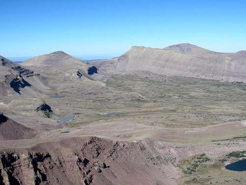
Across Timothy Lakes basin and race the clock
Before descending all the way into the Timothy Lakes Basin I picked out a tall dark landmark to use for navigation. It was standing tall like a charcoal gray monument at the east end of E Timothy Lake and would help me to stay on course when down in the depths of the basin where willows and slight undulations obscured the lakes between which I wished to hike. In the basin the occasional trickle of a stream or the mucky mush of a bog forced me to meander rather than march in a neat and tidy straight line. The tall navigation landmark served me like a lighthouse would serve a sailing ship and led me directly to my intended goal. From there it was a matter of crossing the outlet stream, finding one of the cairns I had seen earlier and then re-tracing my steps along the well-defined path which would lead me back “home.”
My timetable was holding, more or less. Reaching Deer Lake at 6:40 brought me relief, for I knew the remaining trail and could do the entire section in the dark if need be. A short break at the lake and I was now scooting along as fast as my tired dogs would allow in an effort to make the stream crossings in daylight. It was looking likely that the first crossing would be fine, but that the second one might be pushing the limits. That assessment was correct.
At 7:15 I began the first crossing on the return trip, reminding myself that official sunset was about 15 minutes away. The costume change and crossing ate up those fifteen minutes, so there I was, three minutes away from sunset and twenty minutes away from the final crossing. Whoa, Nellie. With adrenalin helping me along I made excellent time to the take-off-the-boots point at the final crossing and slopped across a small bog, thrashed through and down along a small tributary and listened as the roar of the rushing waters attempted to intimidate me in the fading twilight.
It would have been nice had I erected some kind of cairn or stick pile to mark where to cross this stream, but I hadn’t done that. As a result I was using my headlamp to illuminate the opposite shore in an effort to see where the trail from that side led down to the water’s edge. It took me five minutes to successfully locate the desired place, and then it was gratifying to see how effectively the headlamp allowed me to see into the water and pinpoint where to place my feet. As I carefully maneuvered my way across to the waiting trail I knew that the chilling waters were having their last shot at my skinny legs. Ah, now I didn’t care because it was a piece of cake from there: no more crossings, no more trail fading, just a pleasant evening walk under a promised full moon back to the campsite.
And that’s what it turned out to be. The full moon rose over the large lump of mountain to my southeast about 8:40; I had resumed hiking after the stream crossing at 8:10. Although tired from a very long day, the excitement of knowing that just a couple of miles separated me from food and rest invigorated both body and spirit, and I truly enjoyed the remainder of the hike.
Safely back at the still deserted campsite I unfolded my patriotic red-white-and-blue lawn chair, unwrapped my Subway turkey breast sandwich and just thanked a gracious God for the blessings of safety and beauty He had granted to me on this 28-mile 16+30 day in the Uintas. Still alone and hearing only the tumbling waters of the Swift Creek and the Yellowstone River to my north and west I unzipped my tent, climbed into my sleeping bag and fell asleep. An occasional breeze stirred the pine tree boughs just enough to knock loose a pine cone at varying intervals. Several plopped on my tent and made me wonder just how alone I was…
The following morning brought more sunshine and me to the return leg of my 3-day journey. On the road by eight o’clock I at last saw another person after 30 minutes of driving. I drove home without incident, happy with the knowledge that my visits to the Utah Thirteeners had been done without incident and in total safety. Life is good.


Comments
Post a Comment